United Nations Economic Commission for Africa - Africa
Preparatory Meeting on Global Geospatial Information Management
8 – 10 August, 2011, Addis Ababa, Federal Democratic Republic of
Ethiopia
|
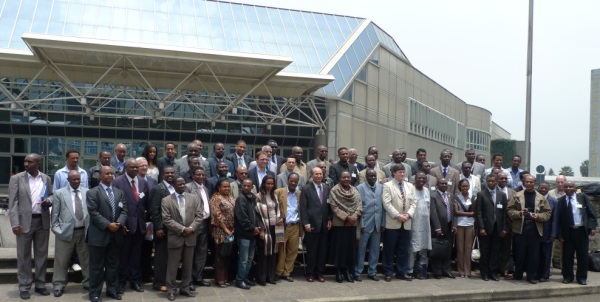
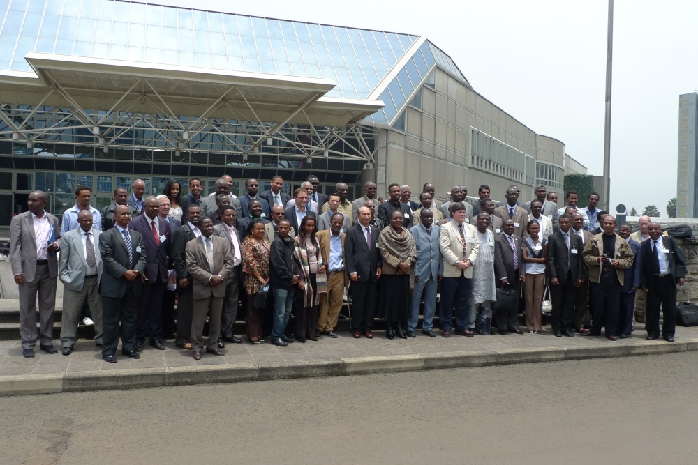
Delegates to the GGIM Africa Preparatory Meeting in front of the
United Nations Conference Centre, Addis Ababa, Ethiopia |
Preamble
United Nations Economic and Social Council made history on 27th July 2011
in Geneva by establishing a new intergovernmental body, the United
Nations Committee on Global Geospatial Information Management, to bring
together, for the first time at the global level, government experts from
all member states to consult on the rapidly changing field of geospatial or
location information. The global surveying community must recognize the role
of the United Nations in recognizing the urgent need for actions to promote
and strengthen international cooperation in the area of global geospatial
information.
The global surveying community must also take cognizance that global and
regional forums are been convene as a result of this historic decision will
promote comprehensive dialogues with all relevant actors and bodies
emphasizing the importance of promoting national, regional and global
efforts to foster the exchange of knowledge and expertise as well as to
assist developing countries in building and strengthening national
capacities in this field.
FIG welcomes this United Nations decision, intends to contribute towards
this global mechanism to foster location-based and geospatial information,
applications and services, aim at extending the benefits of location or
geospatial information for the betterment of society, environment and
economy.
The United Nations Economic Commission for Africa (UN-ECA) has taken the
role to lead the initiative in Africa, so as to ensure that GGIM adequately
reflects African issues and shape its direction and dimension to reflect
Africa’s interest. The Commission convened the GGIM Africa Preparatory
Meeting to consult member states in Africa with a view to develop the
continent’s needs, prospects and vision for an overall Geoinformation
Governance in Africa.
UN-ECA Africa Preparatory Meeting on GGIM
The main aim of the meeting was to establish a clear plan of action
towards an active participation of African governmental officials and
stakeholders in the GGIM initiative. The formal objectives were:
- To assess the key challenges, opportunities and constraints relating
to geospatial information management in Africa;
- To develop a common vision, approach and contribution for the Africa
region;
- To define an African broad plan of action for the initiative future
activities; and
- To prepare African governmental officials and stakeholders to the
GGIM initiative.
The Africa Preparatory Meeting was convened with an overarching
consideration of geospatial information governance and to recommend any
action that may be required to guide member states in achieving a better
coordination mechanism for geospatial information management.
Deputy Executive Secretary, Ms Jennifer Kargbo, on behalf of the
United Nations Under Secretary-General and Executive Secretary of Economic
Commission for Africa, Mr. Abdoulie Janneh officiated the opening of
the three-day Preparatory Meeting with Ms Aida Opoku-Mensah, Director
of ICT Science and Technology Division, the Convenor of the meeting in
attendance.
The three-day meeting was chaired by Dr. Derek Clarke of South
Africa was attended by delegates from the following African member States:
Benin, Botswana, Burkina Faso, Burundi, Cameroon, Republic of Congo, Côte
d’Ivoire, Ethiopia, Ghana, Guinea, Kenya, Madagascar, Malawi, Mali,
Mozambique, Namibia, Niger, Nigeria, Senegal, Sierra Leone, Seychelles,
South Africa, Swaziland, Togo, Uganda, Zambia.
Also in attendance were resource persons, observers and exhibitors from
the African Association of Remote Sensing of the Environment, AARSE (South
Africa); AfricaScope (South Africa); Centre d'Etudes, de Recherche et de
Production en Information pour l'Environnement et le Développement Durable,
CERPINEDD (Burkina Faso); Environmental Information Systems in Africa,
EIS-AFRICA (South Africa); GEODE Consult (France); Ordnance Survey (UK);
Regional Centre for Training in Aerospace Surveys, RECTAS (Nigeria);
Regional Centre for Mapping of Resources for Development, RCMRD (Kenya);
Southern and Eastern African Mineral Centre, SEAMIC (Tanzania), as well as
the African Union Commission, UNDP, UNDESA and UNECA and FIG.
More than 61 delegates attended this meeting. The President of FIG made a
presentation at the meeting on capacity building and knowledge transfer and
stressed that there are three important aspects –
- capacity is not of a passive state but is part of a continuing
process;
- ensures that human resources and the way in which they are utilized
are central to capacity development; and
- requires that the overall context within which organizations
undertake their functions will also be a key consideration in strategies
for capacity development.
He promoted FIG’s view that capacity development is a concept that is
broader than institutional development since it includes an emphasis on the
overall system, environment and context within which individuals,
organizations and societies operate and interact. He also mentioned that
knowledge transfer need not be one-way but recognize that knowledge creation
is not the sole domain of any one actor in a system and hence knowledge
transfer can be two-way.
He highlighted current FIG initiatives and activities with the aim to
explore opportunities and possibilities to collaborate with UN-ECA to
further attain the aim and object of GGIM and extend the value and
usefulness of GI for the benefit of all. He drew the attention of the
meeting to the various task forces within FIG especially the FIG Task Force
for Africa and its ongoing activities in Africa that aim to contribute
towards poverty alleviation, economic growth, and environmental
sustainability.
Outcome of the Africa Preparatory Meeting
The meeting concluded with the adoption and issuance of the “Addis
Ababa Declaration on Geospatial Information Management”, an African
Action Plan on Geospatial Information Management that is broad and took into
account –
Policy and Governance
- Strengthening national policies and strategies to develop and
implement SDI/GIM.
- Promoting the establishment of legislative frameworks.
- Facilitating the establishment of an all-inclusive national
committee to coordinate GI.
- Promote sustainable funding mechanisms for NSDI.
- Initiating an outreach campaign to politicians and other high level
decision-makers.
- Promote the closer institutional relationships between the National
Statistics Office and the National Mapping Agency.
- Promote data sharing policies, recognizing Intellectual Property
(IP) and copyright issues.
Common Framework and Tools
- Support the operationalisation of the African Reference Frame
(AFREF) to provide a common spatial reference frame across Africa.
- Support the Mapping Africa for Africa (MAfA) initiative
- Support the development and implementation of geospatial information
standards
- Interoperable systems
- Open access
- Compiling best practise
- Encourage Private Public Partnerships (PPPs).
- Sensitise NMAs and NSOs around appropriate technological
advancements
Capacity Building and Knowledge Transfer
- Institutional reforms and strengthening.
- Develop a clear capacity building strategy at all levels to build an
enabling environment including capacity among users to fully utilise
geospatial information
- Build upon existing efforts, structures, institutions and
institutional arrangements espe¬cially when there is an absence of
political support or legislation.
- Formulation of a holistic capacity development strategy looking
beyond training and skills development. The strategy should address all
levels of capacity (individual, organisational, and enabling
environment), as well as core issues including knowledge, leadership in
GI, institutional arrangements, and accountability mechanisms that
ensures engagement with all stakeholders to capture and utilize their
feedback as well as the collective capacities (knowledge, ways of
working, and means) to make GI more demand-driven and service-oriented.
International Coordination and Cooperation in meeting Global Needs
- Encourage cooperation to ensure mutually beneficial partnerships.
- Provision of geospatial information focusing on Africa’s priority
socio- economic development needs (MDGs):
- Support access to appropriate imagery to support the development of
fundamental geospatial datasets.
CheeHai TEO
12 August 2011
|
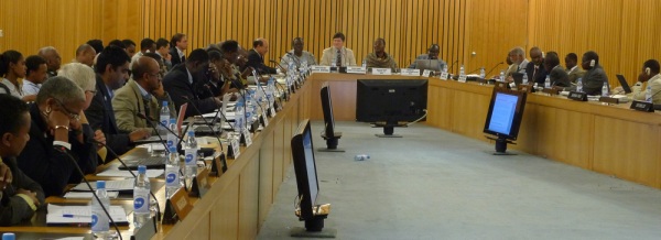
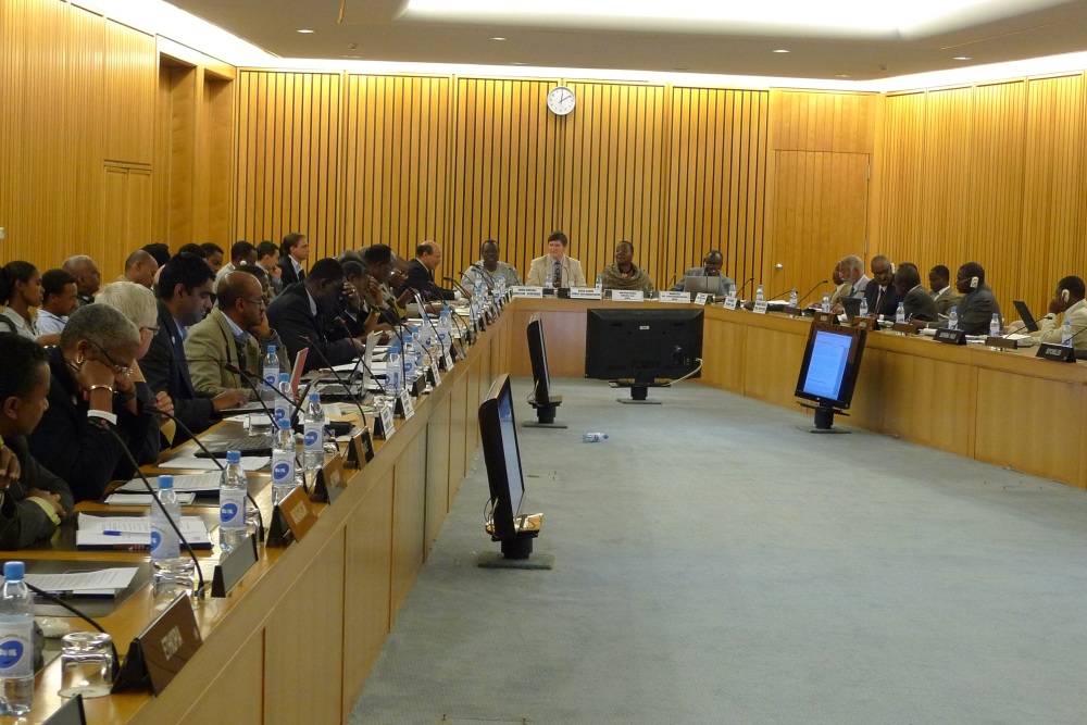
GGIM Africa Preparatory Meeting in session chaired by Dr. Derek
Clarke (South Africa), Andre Bassole (CERPINEDD) as the Rapporteur,
officiated by Ms Aida Opoku-Mensah and facilitated by Mr Makane Faye
(UN-ECA) |
15 August 2011
|