| |
FIG PUBLICATION NO. 72
Best Practices 3D Cadastres
3D Cadastre Joint Working Group Commission 3 and Commission
7
FIG REPORT
Editor: Peter van Oosterom
|
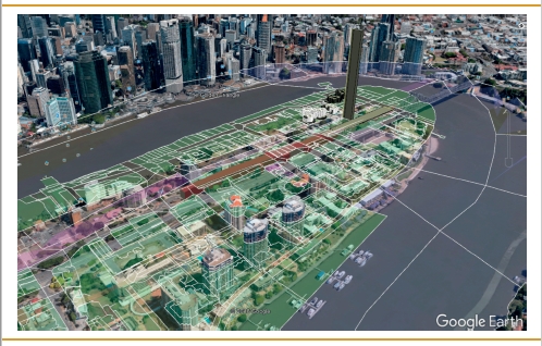
The cover illustrations shows a screenshot of the prototype of
a webbased 3D Cadastre dissemination system built on top of Google
Earth. Looking from the South-East towards Kangaroo point (Brisbane,
Queensland),
note the correspondences between the cadastral objects and the
topographic
objects, 50 meters below. |
PREFACE
Over the last 15 years or so, a number of political, economic,
environmental and social factors as well as the rapid technological
innovation have profoundly changed the outlook for good management of land,
the sea and especially the built environment. In this context, the issue of
security of tenure and registration of property rights is recognized as an
increasingly important component for eliminating poverty and achieving
sustainable development of land, real estate and property markets in all UN
member states, particularly in urban areas.
In view of the Sustainable Development Agenda 2030 all UN member states
are developing and modernizing their cadastre and land registration systems
and in parallel formalizing their property markets. Present land
administration systems and cadastres need re-engineering; they must
continually evolve to cope with the ongoing megatrends, such as
urbanization, demographic change, societal disparities, the digital
transformation, volatile global economy, anthropogenic environmental damage
and so on.
Much of the current research by the surveying profession in this field
focuses on issues related to 3D geo-information, tools for data collection,
cloud solutions, data management, optimizing processes and web-based
information dissemination; standardization of 3D information, advanced
modelling and visualization, as well as formalizing and building sustainable
real estate markets as a pillar for robust economic urban growth; and
related policies, legal and institutional aspects and knowledge sharing in
operational experiences, the emerging challenges and the good practices. The
significance of these areas of interest for the good management of land, the
sea and especially the built environment is well understood.
It is mainly about people and their living in urban settlements. It is
mainly about developing the “cities we want”, digitally networked and
intelligent. And we, as geo-information professionals, vendors, providers,
managers, professionals as well as academics and researchers, are expected
to develop services and tools to deliver administrative, economic and social
benefits. Our colleagues, representatives of business, academia and public
administration; managers of geodata from all over the world; young
entrepreneurs and creative minds; all are working toward the same goal,
trying to increase the “value” of geodata for the people. They do so in
order to get more benefit, more transparency, more safety, more
environmental quality, more growth, more fairness, more efficiency in
governance of urban areas, more smart cities.
No reality has a more direct bearing on the subject of 3 dimensional
geo-information and cadaster than the growth of large cities, especially in
the developing countries of the world, and especially in the phenomenon of
the mega cities. For our young readers let me give some impressive
information. A mega city is an urban area of 10 million population or more.
The Economist “Pocket World in Figures” 2016 Edition, lists thirtythree mega
cities of the world from Bangalore, India at ten point one million,
thirtythird
on the list, to number one Tokyo at thirty-eight million. The World Health
Organization (WHO) has reported that in 2014 fifty-four percent of the
world’s people lived in urban areas, up from thirty-four percent in 1960.
The tipping point, according to most authorities, occurred in 2007 when
there were more urban dwellers than rural residents in the world: the
so-called “urban millennium.”
The United Nations predict that by 2050 sixty-six percent of the world’s
population will live in urban areas.
Much is being written about the growth of urban populations and the
concurrent growth of urban infrastructures and institutions to support this
huge growth of twothirds of the world’s people in the cities. Of all the
institutions that must be developed to anticipate, keep abreast of and
support this growth, the cadaster stands foremost in the interest of
commerce, real estate investment, municipal revenue, and personal property
security, not to mention urban planning and management.
As the cities grow they grow vertically as well as horizontally thereby
introducing the element of the third dimension. Recent innovative thinking
has introduced the concept of a multi-dimensional multipurpose land
information system. It is a logical extension of the 3D cadaster concept,by
adding the time dimension and the detail/scale dimension to the equation.In
a discussion of “cost effectiveness” one must consider time, that 4th
dimension that we speak of. In time, we are usually referring to land titles
history and time-sharing
rights, or how the shape and size of land parcels and cadastral objects
change over time, but it is also a matter of time-cost in the construction
of the cadaster, as well as the time/property value relationship. As the
great cities of the world become mega, the value of land and its
improvements grow as well. Thus the time/value relationship and its impact
on land administration and the need for continuing research on fundamental
policy issues of technical administrative, legal and financial aspects of
land administration.
This publication is a further contribution of FIG in this on-going
process of improving land administration systems. It responds to the need
for international research in building effective land administration
infrastructures with modern information technology that will support the
2030 global policy goals for sustainable development. This study takes into
account the recent developments that have taken place, and I hope that it
will lead to a better understanding of the concept of a 3D cadaster.
Chryssy Potsiou FIG President
(2015-2018)
INTRODUCTION
At the end of the two most recent 4-year terms (2010-2014 and 2014-2018)
of the joint commission 3 ‘Spatial Information Management’ and commission 7
‘Cadastre and Land Management’ FIG Working Group on 3D Cadastres, it was
decided to collect the best known practices in a single FIG publication. Key
authors were invited to lead a chapter on one of the following topics:
- Chapter 1. Legal foundations (Dimitrios Kitsakis),
- Chapter 2. Initial Registration of 3D Parcels (Efi Dimopoulou),
- Chapter 3. 3D Cadastral Information Modelling (Peter van Oosterom),
- Chapter 4. 3D Spatial DBMS for 3D Cadastres (Karel Janečka), and
- Chapter 5. Visualization and New Opportunities (Jacynthe Pouliot).
The mentioned lead authors have each teamed-up with a group of authors to
produce their chapters. A lot of inspiration was found in the earlier 3D
Cadastres activities of FIG, such as the various 3D Cadastres workshops, the
two 3D Cadastres questionnaires, and the presentations and publications at
the 3D Cadastres sessions at every FIG Working Week and Congress. The result
is a quite extensive FIG publication of about 250 pages, which has been
language checked by native English speakers. Based on the
long version this shorter
version was produced. The short version is available as FIG
publication both in hard-copy (paper) and soft-copy (pdf online). The long
version is published only in soft-copy form and in the style of the FIG
proceedings.
The FIG publication ‘3D Cadastres Best Practices’ has quite a long
history. Many 3D Cadastral activities have been conducted during the past
two decades: six FIG 3D Cadastres workshops, sessions at FIG working weeks
and congresses, three special issues in international scientific journals,
several 4-year terms (2004-2008, 2010-2014 and 2014-2018) of the joint
commission 3 and commission 7 FIG Working Group on 3D Cadastres, and two
questionnaires (2010 and 2014). Closely related to these workshop are the
special issues of international scientific journals. Three times the
initiative was taken to invite selected authors, based on review of full
workshop papers and presentations / discussions at the workshop, to submit a
significantly extended / changed version to the special issue. After
submitting, the paper has gone through the peer review process of the
journal. This resulted in the following three special issues as indicated by
their introductions/editorials:
- Christiaan Lemmen and Peter van Oosterom (2002). 3D Cadastres, In:
Computers,
Environment and Urban Systems, 27, 337–343.
- Peter van Oosterom (2013). Research and development in 3D Cadastres,
In: Computers,
Environment and Urban Systems, 40, 1-6.
- Peter van Oosterom and Efi Dimopoulou (2018). Research and
Development Progress
in 3D Cadastral Systems. In: ISPRS International Journal of
Geo-Information,
7(2), 5.
The first more concrete versions of texts towards the FIG publication ‘3D
Cadastres Best Practices’ was in the form of four overview reports, each
presented at the “5th International FIG Workshop on 3D Cadastres”, organized
in Athens, Greece, 18–20 October 2016:
- Dimitrios Kitsakis, Jesper Paasch, Jenny Paulsson, Gerhard
Navratil, Nikola Vucic,
Marcin Karabin, Andréa Flávia Tenório Carneiro and Mohamed El-Mekawy: 3D
Real Property Legal Concepts and Cadastre: A Comparative Study of
Selected
Countries to Propose a Way Forward.
- 2. Efi Dimopoulou, Sudarshan Karki, Roic Miodrag, José-Paulo Duarte de
Almeida,
Charisse Griffith-Charles, Rod Thompson, Shen Ying and Peter van Oosterom:
Initial Registration of 3D Parcels.
- Karel Janecka and Sudarshan Karki: 3D Data Management.
- Jacynthe Pouliot, Frédéric Hubert, Chen Wang, Claire Ellul and Abbas
Rajabifard:
3D Cadastre Visualization: Recent Progress and Future Directions.
Discussions during and after the 2016 Workshop resulted in the decision to
split Chapter 3
into two parts: one on information modelling and one on data management. The
author
teams were further reinforced and each produced a next version of their
chapters, which
were reviewed by colleagues from other author teams. These actions were
conducted before
the FIG Working Week, Helsinki, Finland, 29 May – 2 June 2017 and discussed
at the
working week by representatives of each of the chapters. The review comments
were processed
in the second half of 2017 by the authors teams and all chapters were proof
read by
native English speakers and finally edited to get an uniform style.
The FIG publication ‘3D Cadastres Best Practices’ hopes to provide a clear
and comprehensive
overview to both the newcomers and experts in the 3D Cadastres community.
For sure this is just a snapshot of the current state and our knowledge must
further evolve
with the many challenges that are ahead of us, including the emerging
mega-cities due
to further urbanization. Many developments are ahead of us and to name just
a few: revision
of LADM (with potentially more detailed 3D spatial profiles), Marine
Cadastre, deep
integration of 3D space and time (4D Cadastre), new data acquisition
techniques (including
VGI), growing information infrastructure (of which Land Administration is a
part), and
new visualization and dissemination techniques (including VR and AR).
Already, the next
step of our on-going journey is planned: the 6th International FIG Workshop
on 3D Cadastres,
to be organized in Delft, The Netherlands, 2–4 October 2018. And also this
time a special
issue on 3D Cadastres is planned: to be published in Land Use Policy (2019
or 2020).
It was a great pleasure to be involved in the creation of the FIG
publication ‘3D Cadastres
Best Practices’. This was mainly due to the constructive and open
collaborations of
all involved. First of all I would like to thank the lead authors, the
authors of chapters in
the publication, but also the authors of papers at past FIG 3D Cadastres
workshops and
other FIG events, for their continuous contributions to the field of 3D
Cadastres. Next, it
is important to remember the hard work the reviewers (programme committees
members)
have put into all their constructive comments and adding many ideas and
views
to those of the original authors. Many, many thanks for this often rather
invisible task.
Finally, I would like to thank Sudarshan Karki for the English proof reading
of an incredible
amount of pages and Dirk Dubbeling for the last checks and formatting to
make
sure the publication gets an uniform look and feel. Great teamwork, thanks
for the many
years of collaborations.
Prof Peter van Oosterom
Chair of the FIG 3D working group on 3D Cadastres
Read the full FIG Publication 72 in pdf
EXTENDED VERSION
Copyright © The International Federation of Surveyors (FIG),
November 2018.
All rights reserved.
International Federation of Surveyors (FIG)
Kalvebod Brygge 31–33
DK-1780 Copenhagen V
DENMARK
Tel. + 45 38 86 10 81
E-mail: FIG@FIG.net
www.fig.net
Published in English
Copenhagen, Denmark
ISSN 1018-6530 (printed)
ISSN 2311-8423 (pdf)
ISBN 978-87-92853-83-7 (printed)
ISBN 978-87-92853-84-4 (pdf)
Published by
International Federation of Surveyors (FIG)
Layout: Lagarto
|