Article of the Month -
April 2006
|
Charting Nigerian Waters for Safer Navigation
Surv. (Chief) Innocent N. EGBUH, Nigeria
 This article in .pdf-format
1)
This paper has been presented at the 5th FIG Regional Conference – Promoting
Land Administration and Good Governance to be held in Accra, Ghana, March
8-11, 2006.
Key words: wrecks, danger to navigation, charts.
1. INTRODUCTION
Hydrographic surveys measure and define the configuration of the bottoms
and adjacent land areas of water bodies, especially as they pertain to
navigation. This information is critically important to the production of
nautical charts and is, also, useful to the fishing industry and coastal
zone managers. They are the primary responsibility of the Coast Survey's
Hydrographic Surveys Division, like Nigerian Ports Authority (NPA), National
Maritime Authority (NMA), National Inland Waterways Authority (NIWA), etc.
The primary product of a hydrographic survey is a smooth sheet. The
smooth sheet depicts corrected depths relative to an appropriate vertical
datum (usually a water level datum) along with relevant shoreline derived
from a variety of remote sensing techniques. Smooth sheets also depict
hazards to navigation (rocks, wrecks, obstructions, etc.), shoal
developments, channel delineations, aids to navigation and landmarks.
The principal objective of hydrographic surveys is to obtain basic data
for the compilation of nautical charts with emphasis on features that may
affect safe navigation. In addition to measuring water depths, surveys
identify hazards to navigation, delineate channels, and verify aids to
navigation and landmarks. Each survey represents a comprehensive record of
the coastline and adjacent waters. A record of changes caused by natural
processes and human activities can be compiled from a review of contemporary
and prior surveys of the same area.
2. HISTORICAL BACKGROUND
In the Maritime industry, “wrecks” refers to a vessel that is sunk,
stranded, or abandoned in a harbour, dock, pier, tidal water, or port
approaches under the control of a harbour authority. Wrecks include jetsam,
floatsam, lagan, and all derelicts (including logs) floating or submerged in
the tidal waters or the operational shores of a nation.
Wrecks are viewed with seriousness, in international shipping, because
they constitute danger to navigation, and to lifeboats engaged in rescue
operations and other services at a country’s harbour and waters. The
International Maritime Organisation (IMO) insists that member countries have
a clear waterway and a regime of clean navigable waters. In developed
countries, very special attention is given to the issue of wrecks. Apart
from imposing stiff penalties on owners of wrecks, the English Law also
empowers nearly all harbour authorities with dual and, to some extent,
overlapping power to remove wrecks where the wrecks pose significant
dangers.
Although Section 273 of the Merchant Shipping Act Cap 224 Laws of
Federation of Nigeria 1990 contains some provisions on “Dealing with wrecks”
the Act is not adequate on how to promptly deal with the issue of wrecks,
even when they constitute serious danger to navigation and/or the
environment. It is not surprising, therefore, that wrecks litter Nigerian
waters, posing various risks to navigation, pilotage, search and rescue,
recreational boating and routine patrol.
In recent times, there have been reports of abandoned ships at the ports
and territorial waters of Nigeria, constituting danger to navigation, and
threat to national security. Although there are Government Receivers of
Wrecks in each of the country’s ports, no significant efforts have been made
to firmly address the matter of wrecks, or improve the condition of wrecks
on Nigeria waters. Non-availability of funds to promptly address the issue
is reported to be a major consideration for this lack of significant effort.
The problems posed by wrecks include:
- Risks to navigation and recreational boating,
- Constraints, and danger to search and rescue operations in
emergencies,
- Environmental pollution and destruction of marine habitats,
- Security risk, as abandoned vessels could be used as hideouts for
criminals, especially robbers.
Government recognizes these problems, and had made some feeble efforts in
the past to address the problems. This observation is included in the
findings of a Federal Ministry of Transport Ministerial Committee on Wrecks
in Nigeria. According to the report of the Ministerial Committee, two
Committees had been set up previously.
Firstly, on October 5, 1988, Maglee Salvage Company entered into contract
with the Federal Ministry of Transport (FMOT) for the clearance of wrecks,
derelicts, floatsam, and other obstructions from the nation’s navigable
waters, ports, dockyards, and shorelines. A change in government policy, via
Circular No. SCD/2/320/1/233 of 6 February 1990 reviewed all
agreements entered on behalf of government for sales and export of scrap to
avoid further export. This circular put an end to the contracts. This
initial effort, which involved a detailed listing of the location of the
scraps, and full mobilization for removal, were aborted.
Again, in November 1993, a main committee of the Federal Ministry of
Transport and Aviation was constituted and charged with the following
responsibilities:
- To identify and position the wrecks, derelicts, floatsams and similar
obstructions within the navigable waterways of Nigeria (including
international and local ports) etc.
- Suggest the best economic ways of clearing the obstructions (with the
financial implication) of the same.
A Sub-Committee of this Committee was constituted and given the following
Terms of Reference (TOR):
- To collect, compile, collate, and coordinate inputs from the Nigerian
Navy (NN); Nigerian Ports Authority (NP Plc); Nigerian Shippers’ Council
(NCS); Government Inspector of Shipping (GIS), and the Inland Waterways
Department (IWD) of the Ministry, on the identified and identifiable
location of obstruction on all ports approaches and navigable channels.
- To use relevant base maps and plot each point of location by
indicating the longitude and latitude of the same.
- While focusing on the approach of ports and navigable channels,
efforts should be made to draw the line between the obstructions that
constitute immediate navigation problems and those that were not in their
respective vicinities.
- Suggest the best economic way(s) of getting rid of the obstructions
and, where necessary, identify safe passages around any serious
obstructions, with attendant implication in both cases.
- An Interim Report should be rendered within a month from the inaugural
date while the final report, with useful recommendations, should be
submitted to the Committee within two months.
The Committee Report concluded that as of 28 May 1994, no significant
effort had been made towards the achievement of these Terms of Reference,
simply because there were no funds. The absence of any progress informed the
action of government to inaugurate another Technical Committee on Wrecks in
Nigerian Waters on July 10, 2002 to address the issue. Almost ten (10) years
after the last effort, the wreck situation in Nigeria waters has worsened,
yet there has been no serious wreck removal effort since this period.
All the efforts above suffered from:
- Inadequate funding to meet the needs of the data collection exercise;
- Inadequate time frame within which to produce results commensurate
with the magnitude of survey expected;
- Weather problems due to disturbances from rains;
- Equipment problems such as the lack of positioning system in some
areas, and total absence of sounding, and side scan sonar equipment.
3. PROJECT GOALS
Our mandate as reflected in the Contract agreement may be summarized as:
- To conduct a bathymetric/wreck detection survey for the purpose of
identifying the positions of wrecks/derelicts in Lagos Ports Area;
- To identify the wrecks that constitute the most danger to navigation
in Lagos Ports Area, with a view to taking adequate steps towards removal;
However, there were overall project goals. These include
- To ensure the safe navigation of ships in Nigerian waters
- To fulfill Nigeria’s national and international responsibilities in
Africa and to emphasize Nigeria’s close interests in the region,
especially with the ISPS Code
- To satisfy future information needs Nigeria may have in her waters
- To supplement the existing chart coverage of other nations by the
addition of accurate and recent coastline data
- To provide a framework for future survey work, especially in relation
to monitoring of and early removal of wrecks/derelicts
- To contribute to the International Hydrographic Organisation’s (IHO)
International chart scheme for Nigeria
4. TECHNOLOGY DEPLOYED
To collect up-to-date hydrographic survey data and to satisfy the
maritime constituency, Humber Marine Werks Ltd developed a survey priority
plan to identify those areas with the highest risk of serious maritime
accidents. This risk assessment is based on a combination of traffic volume,
inadequacy of charts or surveys, and potentially insufficient underkeel
clearance.
More modern technologies were implemented to increase the quality and
productivity of the survey. This included the detection, location, and
identification of wrecks and obstructions primarily using side scan sonar,
magnetometer, and Differential GPS technology.
The strength of the return echo is continuously recorded creating a
"picture" of the ocean bottom where objects that protrude from the bottom
create a dark image (strong return) and shadows from these objects are light
areas (little or no return).
5. STANDARDS ADOPTED
The standards adopted for the entire survey conforms to the National
Ocean and Atmospheric Administration (NOAA), National Ocean Service (NOS)
Hydrographic Surveys Specifications and Deliverables.
These technical specifications detail the requirements for hydrographic
surveys to be undertaken by either NOAA field units or organizations under
contract to the Director, Office of the Coast Survey (OCS), NOS, NOAA, U.S.
Department of Commerce.
The specifications are based in part on the International Hydrographic
Organization’s Standards for Hydrographic Surveys, Special Publication 44,
Fourth Edition, April 1998, especifically for Order 1 surveys. Hydrographic
surveys classified as Order 1 are intended for harbours, harbour approach
channels, recommended tracks, inland navigation channels, coastal areas of
high commercial traffic density, and are usually in shallower areas lower
than 100 meters depth.
6. TEAM/RESOURCES DEPLOYED
Equipment & Personnel Sourcing Policy:
“Humber Marine shall retain a core staff of professionals and consultants
relevant to our overall Company objectives. But for the execution of
specific contracts, Humber shall optimise the utilization of locally
available equipment and skills without sacrificing quality and safety.”
In line with this broad Company policy, we deployed the following resources
in the execution of the survey:
6.1 Technical Crew
- Surv. Innocent Egbuh - Hydrographic Surveyor/Team Leader
- Tom Logan - Consultant Marine Engineer & Diver
- Roger Zaune - Consultant Oceanographer
- Titus Igbokei - Senior Geophysical Engineer
- Temitope Solomon - Hydrographic Surveyor
- Henry Adimoha - Surveyor
- Ovie O. Anaidhaimu - Surveyor
- Rufus O. A. - Underwater Engineer
- Emeka Awazie - Driver
- Bassey Etim - Driver
6.2 Support Staff
- Eme Abiayi - Technical Director
- Chris Aruwa - PRO/Administration
- Mike Ukeka - Chief Security Officer (Site/Office)
6.3 Software
- HYPACK Max hydrographic software
- Trimble GeoExplorer Pathfinder GPS software
- Magnetometer software
- AutoCAD 2000 Computer-Aided Design (CAD) software
- MicroStation SE (CAD) software
- Surfer Digital Terrain Modelling (DTM) software
- SurvCAD software, includes transformations
- HydroCAD software for reducing sounding data
6.4 Support and Outside Services
In the course of carrying out the survey, support, cooperation, and
outside services were obtained from the following sources:
- Bathymetric Survey - GeoLab Technical Services (Nig) Ltd
- Sonar/Magnetometer sweeping - GeoLab Technical Services (Nig) Ltd
- Diving Investigation Services - DiveTech (Nig) Ltd, Lagos
- Purchase of Charts and software - Meridian Chartware Ltd., Norwich, UK
- Hydrographic equipment - Consultants-Inner Space Technology, New
Jersey, USA.
7. PROCEDURES ADOPTED DURING THE SURVEY
7.1 Horizontal Datum
All positions were referenced to UTM Zone 31. This datum was used
throughout the survey. Documents used for comparisons, such as charts, prior
surveys, and junction surveys were referenced to or adjusted to UTM Zone 31.
All software used on the survey contained the correct datum parameters.
7.2 Sounding Datum
All sounding data were reduced to chart datum, or 0.38 meters below BM1
at East Mole Signal Station.
7.3 Time
Local time was used for all time records.
7.4 Hydrographic Position Control
Total error in the position of soundings, dangers, and all other
significant features, at 95% confidence level, was +/- 5 meters + 5 percent
of the depth.
7.5 DGPS
GPS receivers were configured such that satellites below 10° above the
horizon were not used in the position computations. A minimum of four (4)
satellites was used to compute all positions. There were always more than
six (6) satellites 95% of the time due to clear visibility.
Horizontal Dilution of Precision (HDOP) was monitored and recorded, and
did not exceed 4.0.
7.6 Depth Soundings
Depths were recorded in meters, with decimeter precision. Plotted depths
are also in meters and decimeters.
7.7 Corrections to Echo Soundings
Observed echo sounder depths were corrected for all departures from true
depths attributable to the method of sounding or to faults in the measuring
apparatus. These include draft, velocity, heave, roll, pitch, heading, and
navigation timing error corrections.
7.8 Tide
Tide stations were set up at NPA Dockyard, Apapa & Navy P4 Jetty, at
Victoria Island. Readings were taken at 30 minutes interval throughout the
duration of the survey.
7.9 Towed Side Scan Sonar
Side scan sonar was used for supplementing echo sounding by searching the
region for additional indications of dangers and topographic irregularities.
7.10 Quality Control
Confidence checks of the side scan sonar were conducted once a day.
Confidence checks were also made during the course of survey operations by
noting the check feature on the sonargram.
7.11 Community Affairs, Safety, Health, Environment & Security
(CASHES)
Safety meetings, which focused on potential hazards associated with
inshore marine operations, was conducted prior to the commencement of the
survey. General safety awareness among entire crew members was commendable.
No Lost Time Injury (LTI) was recorded during the period under review.
8. SURVEY PROCEDURE
8.1 Positioning System
The positioning method used for the survey was Sokkia Global Positioning
System (GPS) receiver interfaced with HYPACK navigation software to compute
vessel position from direct satellite observations to get the actual
position.
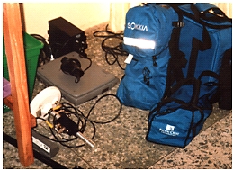
Sokkia Radian GPS Receivers
Photo by: Innocent Egbuh
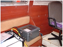
8.2 Navigation And Data Logging System
The navigation system comprised a Compaq Computer driving a printer and a
dedicated monitor for the helmsman. The computer received GPS derived
coordinates in WGS84 from the Sokkia system to output the final grid
coordinates in Universal Transverse Mercator (UTM) Zone 31.
Navigation was conducted with no smoothing applied to the position
computation. The HYPACK navigation system software provided display
presentations suitable for navigating predetermined lines and included a
visual aid for the Helmsman. GPS antenna was used as the Positioning
Reference Point (PRP) for the survey. All other sensors like side scan sonar
and magnetometer tow points offsets were measured and cable out documented
for data/records post-processing.
The HYPACK system was interfaced with the echo sounder, this enabled raw
depths to be recorded in real time and event marking appropriately carried
out. Fix intervals were at 50m for all the sensors and logged in the
analogue traces as well as in the hard disk for onshore post – processing.
8.3 Echo Sounder
Odom Hydrotrac dual frequency (33 KHz/ 210KHz) digital / analogue
recorder was used for survey. The over the side mounted transducer shoe was
marked at 1m intervals.
The transducer was installed rigidly to its bracket and side mounted on
the survey vessel. The transducer shoe was sufficiently deep and well
positioned not to experience turbulence and aeration from the vessel during
data acquisition. The depth of the transducer below waterline was guided by
the calibrated marks on the transducer pole.
Odom Hydrotrac Echosounder onboard survey boat.
8.4 Side Scan Sonar
J.W.Fishers side scan sonar system was used for the survey. During
mobilization, the tow cable was measured and calibrated at 1m intervals to
three times the maximum operating depth throughout the survey. The recorder
was set to 100m to 200m ranges, ensuring a theorical 100% overlap on lines
ran. Cable out, and range scale were noted at the start of each line, and
whenever alterations were made.
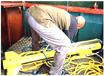
Preparing the side scan sonar for deployment.
8.5 Magnetometer
The magnetometer data was acquired with a JW Fishers Proton - 4
magnetometer. The data was displayed on a chart paper. The magnetometer was
towed 5m astern of the vessel at approximately 2m depth below the waterline
and operated on the 32,000 – 33200 nanoTesla (nT) range.
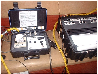
The magnetometer and side scan sonar consoles.
All Photos: Innocent Egbuh
8.6 Survey Administration
Daily progress reports were maintained onboard and regularly reviewed by
the Party Chief and the Survey Representative. The on – line computer system
was interfaced for closure to all analogue and digital recorders. Event
marks corresponding to position fixes were generated automatically from the
navigation computer interface, and passed to the analogue records at fixed
intervals set at 50m.
To facilitate the post – processing it was essential that acquired data
were clearly labeled and cross – referenced to the survey line log. Each
survey line was given a unique identity. Regular checks of time against fix
were also carried out and the analogue records marked accordingly. Vessel
offset diagram and cable out of the towed sensors was documented, taking
care of range, scale, or cable out variations
8.7 Data Processing
Field data were processed using appropriate survey software such as
HYPACK, HydroCAD, SurvCAD, AutoCAD, GPS Pathfinder Office, etc.
GPS positions were processed and differentially corrected in the
coordinate system: UTM Zone 31. Tidal corrections were applied to soundings
and reduced to chart datum or 0.38m below BM1 at East Mole Signal Station.
8.8 Data Presentation
For purpose of the survey, the Lagos Ports Area was divided into 5 blocks
namely, Sheets 1, 2, 3, 4 & 5, plotted on scale 1:5000. In addition, a
composite chart covering the entire area was produced on a scale of
1:12,500.
Each wreck site is highlighted in the chart with symbol of wreck and a
number printed in red colour (e.g. Wrk 12). Database of the wrecks, their
positions, and other attributes was designed and created using Microsoft
Access.
9. SURVEY RESULTS AND FINDINGS
- Water depth in the surveyed area varies from a minimum of 1.1 metres
in the Kirikiri area to a maximum of 24.0 metres in the Lagos Port Limit
in the Lagos Bar.
- One hundred and two (102) wrecks were located at sixty-two (62)
wreck sites within the Lagos Ports Area under survey. Another seven (7)
wrecks were located in the Lagos Bar, making a grand total of one
hundred and nine (109). Some of the sites may have a cluster of two,
three or more wrecks. Each site is numbered with a pre-fix “Wrk” and the
number of wrecks at a site may be determined from the database.
- About twenty-one (21) wreck sites have wrecks either fully or
partially submerged. At least three (3) of the wreck sites were marked
with marker buoys.
- Three portions of the Lagos Ports Area were identified as numerous
wreck areas. Wrecks are highly concentrated in these places.
- Badagry Creek Bay (Sheet 3): This area is opposite the Porto
Novo Creek. Several wrecks are found here. In addition, Buoys 30 & 32 have
drifted to this bay. The present positions of the drifted buoys, and
litter of wrecks in this area are capable of misleading vessels navigating
the channel.
- Snake Island Bay (Sheet 5): This bay overlooks the Tin-Can
Island Turning Basin. Numerous wrecks were found here.
- Kirikiri Channel (Sheet5): It would be difficult to establish,
on a first visit, whether the area is a fishery terminal or wreck colony.
There is high concentration of wrecks on this creek, right from the
entrance. Some of the private jetty owners on this creek have converted
their jetties to wreck dumps, both on their waterfront, and ashore.
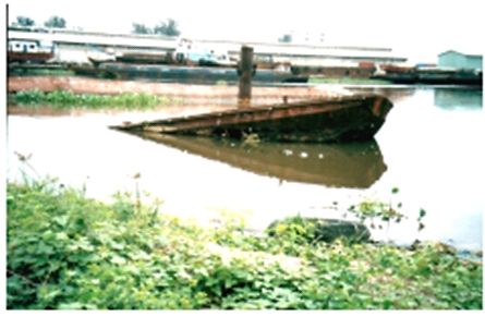
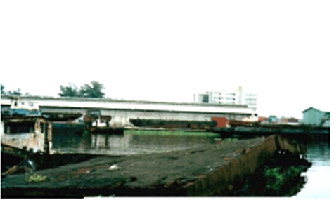
10. PROBLEMS OF WRECKS
The problems posed by these wrecks include:
- Pollution to marine life
- Danger to man’s health
- Environment degradation
- Danger to navigation
- Harbour accessibility/navigation problems
- Security problems.
11. RECOMMENDATIONS
- Our preliminary estimate of the cost of removal of all the wrecks in
Lagos Ports Area is in excess of forty million dollars (USD 40 million).
- However, it is recognized that funding could be a major constraint.
Therefore, we prepared a “Danger to Navigation Report”. It lists, by
sections, wrecks which constitute the greatest risks to navigation and
which should be given priority.
- The National Maritime Authority (NMA) should, as a matter of urgency,
notify the Maritime Industry of the locations and distribution of wrecks
in Lagos Ports Area, and of the dangers they pose to navigation.
- Now that the essential first step to any meaningful process of Wrecks
removal ie detailed hydrographic survey has been accomplished, the NMA
should immediately commence the under-listed subsequent steps:
- Determination of the modalities for the removal of each wreck or
cluster of wrecks.
- Definition of the mode of disposal, including delineation of areas
for dumping of removed wrecks. In this connection, it should be noted
that metal scraps from wrecks can be sold to recover part or all of the
removal costs. There is indeed, ready market for this in iron & steel
recycling industry.
- Since the Removal of Wrecks from Nigerian Waterways is a long, costly
but necessary venture, there is a need for a constant professional factor
linking the implementation of the series of related activities listed
below:
- Preparation of realistic cost estimates for the removal of each
wreck or cluster of wrecks, as basis for the assessment of the
quotations from potential Wreck Removal Contractors.
- Advising NMA\FMT on the realistic basis for determination of the
economic value of the wrecks to be removed.
- Monitoring the performance of actual wreck removal contractors in
the field.
- Up-date of the relevant Admiralty Charts to reflect a clean bill of
health for the waterways after the wrecks shall have been removed.
REFERENCES
- NOAA (2003). NOS Hydrographic Surveys Specifications and Deliverables
- National Maritime Authority
- Nigeria Ports Authority
- Report on previous effort at wreck identification and removal -
Federal Ministry of Transport Technical Committee on Wrecks in Nigerian
waters
BIOGRAPHICAL NOTES
Innocent Ndubueze Egbuh was born on June 17, 1962 in Aba, Abia
State. He studied at the University of Nigeria, Nsukka where he obtained
B.Sc. (Hons) in Surveying, Geodesy and Photogrammetry in 1986. He also holds
a Post-Graduate Diploma in Journalism of the Nigerian Institute of
Journalism (1994). He is a member of Nigerian Institution of Surveyors, a
member of GIS Consultants Association of Nigeria, (GIS Specialist Group),
and a member of Geoinformation Society of Nigeria, (GEOSON).
He has nineteen (19) years of engineering and field surveying practice
experience, during which time he moved from field Surveyor and Party Chief
in the Construction and Engineering industry to Senior Surveyor, and
Assistant Chief Surveyor on seismic exploration crews. He has supervised and
conducted surveys for various methods of seismic data acquisition in various
climates and terrain. Project design, planning and coordination for
Non-Governmental Organisations. Managing medium scale surveying,
engineering, architectural, geoinformation, environmental, and development
consulting company.
In 1991, he was registered as a Surveyor by Surveyors Registration
Council of Nigeria (SURCON). Since then he has been in the forefront of the
awareness campaign of the importance of computers in the Surveying
profession. He distinguished himself in professional life, and has veered
into software development to assist professionals.
Positions Held
NIS National
- Assistant Secretary General, Nigerian Institution of Surveyors (2004-2006)
NIS Rivers State Branch
- Public Relations Officer, Nigerian Institution of Surveyors, Rivers State
Branch, (1997- 1999)
- Secretary, Nigerian Institution of Surveyors, Rivers State Branch,
(1999-2001)
- Merit Award for Untiring Service to the Nigerian Institution of Surveyors
Rivers State Branch
December 2004.
Publications
Egbuh, I. N. (2003). “Setting Up and Operating a Surveying Business”.
Proceedings of the 39th Annual General Meeting of the Nigerian Institution
of Surveyors, Port Harcourt. May.
Egbuh, I. N. (2004). “Setting up and Operating a Surveying Business”.
Proceedings of the 39th Annual General Meeting of the Nigerian Institution
of Surveyors, Kano. May.
Innocent Egbuh is the CEO of AERO-GEODETIC SERVICES (NIG) LTD, a firm of
surveyors, engineers and architects involved in economic and financial
appraisals, feasibility studies, preparation of detailed designs,
programming and supervision of construction works (post-design), and
specialized in computing and drafting/ system support, GPS, GIS and Land
Information Systems (LIS).
CONTACTS
Innocent N. Egbuh
Aero-Geodetic Services (NIG) LTD,
209A Aba Road (Near ABC Transport), Rumuola
P.O. Box 7624
Port Harcourt. 500001
Rivers State
NIGERIA
Tel. + 234 84775449; + 234 84575870
Mobile: + 234 8030634896; + 234 805-5304717
Email: aerogeodeticservices@yahoo.com; innocentegbuh@yahoo.com
APPENDIX
Picture of some of the wrecks
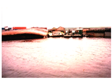
Wrecks: Security problems
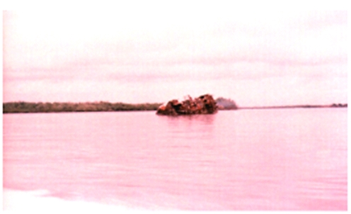
Wrecks: Danger to man's health
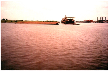
Wrecks: Danger to navigation
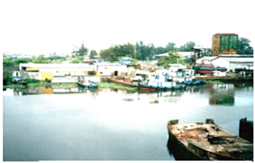
Wrecks: Harbour accessibility / navigation problems
Wrecks: Pollution to Marine life
Wrecks: Environmental degradation
 |


