Article of the Month - April 2023
|
The Surveyor Pirate of the Caribbean
John BROCK, Australia
 |
| John Brock |
This article in .pdf-format
(19 pages)
In this article John Brock takes you to the early days of the
settlements in the USA together with land surveyor and architecht
Barthelemy Lafon. The paper presents an excellent
sample of surveys and edifices attributed to Lafon, along with tales
of some of his raids of piracy. Fascinating... Learn and explore
more about USA at the
FIG Working
Week 2023 in Orlando, Florida
SUMMARY
It appears that in the early days of the settlement of New Orleans,
Louisiana, USA, a career change from the profession of land surveying
and architecture meant venturing into the more lucrative, albeit less
legal, undertaking of a privateer, which is actually a more polite word
for pirate! Land surveyor and architect, Barthelemy Lafon, who had
hailed from France, built up an impressive portfolio of land surveys
combined with an equally extensive corpus of buildings attributed to his
designs. Who knows what influenced this locally reputable pillar of the
community to join with fellow Frenchmen, the notorious brothers Jean and
Pierre Lafitte, the enigmatic pair who had a spurious agreement with the
English and US overlords to sack Spanish vessels (and any others which
ventured into their territorial waters?) and skirted with a death
penalty to loot these hapless captains. It was indeed ironic that this
duo of treacherous characters avoided execution by rendering courageous
support to US General Andrew Jackson in conquering a much larger English
force in the Battle of New Orleans in 1815, virtually being the last
concerted effort by the homeland to suppress the rebellion of their
northern American colonies on US ground. This paper presents an
excellent sample of surveys and edifices attributed to Lafon, along with
tales of some of his raids of piracy.
KEYWORDS: Barthelemy Lafon, New Orleans surveyor,
architect, pirate.
1. INTRODUCTION
Spanish explorer Hernando de Soto discovered the body of the
Mississippi River between 1541-42, but it was not until the Frenchman
Robert Cavalier (Figure 1), Sieur de la Salle, erected a cross in 1682
at its mouth that the territory was formally claimed in the name of the
French Sun King, Louis XIV, for whom Louisiana is named (State of
Louisiana, 2023). In 1718, New Orleans was founded, being named after
Phillipe Duc D’Orleans, younger son of King Louis XIII, with the oldest
cathedral in the US, St. Louis Cathedral, being erected in that same
year. It was destroyed in the 1788 fire to be rebuilt in 1794. Adjacent
to this holy establishment was placed the Cabildo, the Governor’s
residence, in which the later mentioned treaty was signed in 1803. In
1762, the succeeding King Louis XV ceded all of Louisiana west of the
Mississippi to his cousin, Charles III of Spain, with the Treaty of
Paris formally confirming this transfer in 1763 (Chamberlain and Farber,
2014).
In the final years of Spanish administration from the great fire of
1788 to 1803, the enactment of Spanish building codes resulted in the
erection of Spanish colonial style architecture, particularly in the
ironically named French Quarter, such exteriors requiring stucco and
tiled roofs including customary patios and long iron balconies as were
found in the haciendas of southern Spain. Even after the formal
transferral of the Louisiana territories to the US in 1803, the elite
Creole planter-merchant class dominated commerce and the social life of
the burgeoning community for a substantial period from that event
(Chamberlain and Farber, 2014).
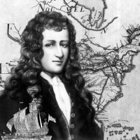
Figure 1: French explorer Robert Cavalier who
claimed the Mississippi River in the name of Sun King Louis XIV to later
give the name of Louisiana to the whole territory.
When the 3rd US President, Thomas Jefferson (also District Surveyor
for Albemarle County), signed the Louisiana Purchase Treaty on 30 April
1803, the continental land mass of the United States of America was to
be doubled, adding to its original 13 states all of the recently
acquired French territory west of the Mississippi River (Figure 2). This
amazing real estate transfer cost the US Treasury a mere US$15 million,
which, even in modern terms, was more like a ‘fire sale’ than a market
value transaction. 530 million acres (828,000 square miles) of land was
obtained for 3 cents an acre in what is the largest land acquisition in
US history (State of Louisiana, 2023). The final hand-over of the lands
from Napoleon Bonaparte took place on 20 December later that year.
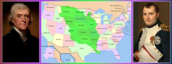 |
Figure 2: Coloured green is the area of land
purchased by the US government from France by the Louisiana Purchase
Treaty, which was signed on 30 April 1803 for US$15 million – US
President Thomas Jefferson on the left and Napoleon Bonaparte on the
right (Rawat, 2018).
Immediately, at the mouth of the mighty Mississippi River, and to the
east, lay the new area later to be the State of Louisiana. Much of the
occupied land had Spanish tenants, who had inhabited the farms during
the Spanish occupation, which preceded the French ownership by about 40
years. In what could be described as the greatest land gazumping in
world history, France’s fanatical self-proclaimed ‘Emperor’ hoodwinked
the cash-strapped Spanish authorities by calling in a debt owed, so that
he could then swiftly pass on the extensive territories west of the
Mississippi to finance his failing battle against the English in arenas
of conflict on the other side of the planet.
It was a commensurate land swindle and double deal, but the new
states of America were unperturbed as they quickly absorbed the
ownership of these neighbouring lands into their vastly expanded
dominion. Although held under the Spanish flag, New Orleans had a
culture identifying with the many French settlers who had migrated from
their homeland with their descendants emerging as a white Creole
merchant/planter class mainly conversing in a dialect of French origin.
2. LAFON’S EARLY YEARS IN NORTH AMERICA
Born in 1769 (the same year as Napoleon Bonaparte!) in the old town
of Villepinte in the Departement de l’Aude, Province of Languedoc, in
France, along the Canal-de-Midi which connects the Mediterranean to the
Atlantic (Cultural Landscape Foundation, 2023), Barthelemy Lafon (Figure
3) spent his first 20 years under the Ancien Regime with Bourbon kings
reigning over a nation where the privileged families enjoyed an elite
lifestyle. However, with his coming of age in 1789 came the Storming of
the Bastille on 14 July 1789, which started the French Revolution. This
uprising meant upheaval and often death to the Bourgeoisie, so he fled
the threat of the guillotine never to return to his birthland.
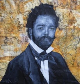
Figure 3: Portrait of Barthelemy Lafon by
Jessica Strahan (2018).
Possibly passing through the spheres of French influence in St.
Domingue or Haiti, he may have travelled through Cuba, but whichever
route he took he made his way to the ‘French’ Louisiana Territory
sometime around 1789-90. The sparsely populated lands are said to have
reminded him of his rustic origins in rural France, and despite Spanish
dominion over the territory since 1763, French was still the prevailing
tongue together with compulsory Catholicism for all residents. Thus, it
must have seemed like divine providence when Napoleon cut the deal to
take the lands from Spain, then just as expediently disposed of all of
the territory to the young US establishment in 1803 (see Figure A1 in
Appendix A).
Shortly after his arrival in his new home, Lafon established an iron
foundry in the lower area of Canal Street and a “brick plantation” in
1801 (see Figure A2 in Appendix A). The need for his architectural
services must have been in strong demand, particularly in the sphere of
public works repair projects. He prepared plans for the restoration of
the city gaol in 1794 due to its damage from the fire of 1788. Four
years later, he was called as an expert to assess the repair works on
the Presbytere and Cabildo, which was the residence of the Governor.
During the period from 1797 to 1799, he brought about improvements to
the covered gutters of the city, while in 1802 he reconstructed the
riverfront levees. For these intervening 13 years, Lafon was in the
right place at the wrong time because a terrible fire had destroyed much
of New Orleans in 1788, which could only be considered a wrong time!
However, for the newly arrived French architect/surveyor it was the
perfect time to join an economy craving new designs for lost residences
or restoration plans for partly damaged structures worth saving. His
expertise in hydraulic engineering was also keenly employed to build and
repair those levees damaged by flooding, which was a constant threat and
still is to this day. He was such a busy man that he engaged another
French-born surveyor, Jean Baptiste Pene, to assist him. He also
employed scribes to prepare many of his survey “warrants”. His survey
duties comprised verifying land grants and land purchases, along with
establishing precise borderlines between extensive rural French long
lots (which meant plantation properties along the Mississippi or the
numerous nearby bayous) or measuring boundary lines of the narrow urban
lots in New Orleans city. Every inch was important with his services
called upon to also evaluate the land for its potential usage (Edwards
and Fandrich, 2018, p.1-2).
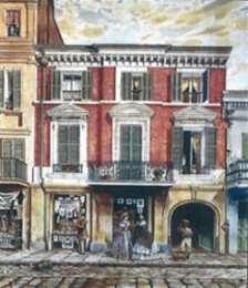
His first private commission is probably in 1794 for a dwelling for
Mademoiselle Jeanne Macarty at the intersection of Conti and Decatur
Streets in a typical colonial New Orleans design with a brick ground
level containing stores, then a half-timber colombage second floor with
plastered formal rooms and wood-panelled chimney breasts. Some other
significant townhouses of the late Spanish colonial era accredited to
Lafon by stylistic comparison are such works as the Barthelemy Bosque
House at number 616 Chartres Street (c. 1795), a later 1790s residence
for Vincent Rilleaux at 343 Royal Street along with another 3-storey
premise at number 634 in the same street (Figure 4), and a c. 1795
building called Joseph Reynes House on a corner allotment at Chartres
and Toulouse Streets. In 1797, he was engaged to build a larger similar
home for the merchant Jean Baptiste Riviere at the corner of Bienville
and Decatur Streets, made taller by adding an entresol as well as
including more elegant features like carved mantles, a rose window and
pediment with a sculpture. He is also credited with the 1799 De La Torre
House, standing at 707 Dumaine Street, New Orleans (see Figure 4)
(Masson, 2012).
 |
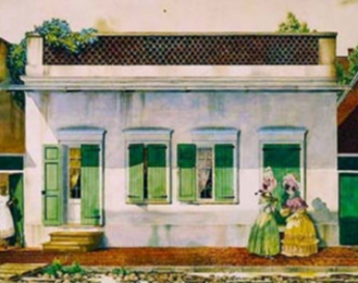 |
Figure 4: (Left) Lafon designed 1795 house at
634 Royal Street, and (right) the 1799 De La Torre House at 707 Dumaine
Street, New Orleans.
3. IN THE NEW ORLEANS SURVEYOR-GENERAL’S DEPARTMENT
As Masson (2012) put it, “Barthelemy Lafon enjoyed a long and diverse
career in Louisiana as an architect, builder, engineer, surveyor,
cartographer, town planner, land speculator, publisher and pirate.” Such
a quotation demonstrates the wide spectrum of activities with which
Lafon was associated, but it is quite an anomalous finale which includes
“and pirate”!
During his formative years in New Orleans, he carried out most
reputable projects in town planning, building and mapping together with
his many exploits in surveying, which create an image of a man fighting
between two worlds of existence. In a Jekyll and Hyde parody, he
performed the professional needs of his community to the fullest, but he
was clearly torn away into a life of swashbuckling adventure in the
dubious underworld of privateering, otherwise recognised as legalised
piracy. As his life story unfolds, this darker side of his character
will arise towards its finale. Nevertheless, his amazing professional
performance belies his disreputable demise.
One of Lafon’s early commissions included an 1803 survey of Galveston
(now Galvez, LA, near Baton Rouge) for the Spanish along with maps and
surveys of New Orleans. Having gained a solid reputation for his private
surveying activities, and despite two bitter disputes relating to two of
his architectural projects which may have sullied his name in this
field, he was seconded to the Surveyor-General of Orleans County between
1804-09, duly appointed by Isaac T. Briggs, Surveyor-General of the
lands South of Tennessee (Edwards and Fandrich, 2018, p.8). During his
service with this department, he still carried on with designing
buildings and creating green subdivisions in some of the new suburbs.
Lafon’s work as a surveyor was said to be “extraordinary”, both
working for private clients and the administration as well as designing
developments adopting the principles of European Garden City designs.
His initially preferred style of map preparation was based on his
Spanish Surveyor-General Carlos Trudeau’s style (Figure 5), but he later
began introducing his own features to the works, such as dual language
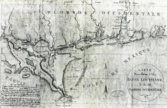
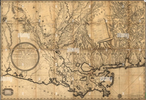
plans (Figures 6-9). He completed work on one of the earliest and most
accurate maps of Louisiana in 1805 called “Carte Generale du Territoire
d’Orleans Comorenant Aussi la Floride Occidentale et une Portion du
Territoire du Mississippi” (Figure 8). Some of his other plans include
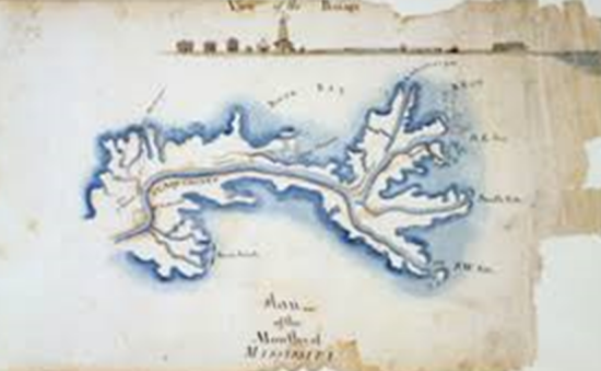
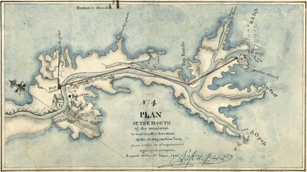
Mouths of the Mississippi (1810 & 1813 – see Appendix B), English Turn
(1814), the Balise (1814), Port St. Jean (1814) and Fort Bower (undated)
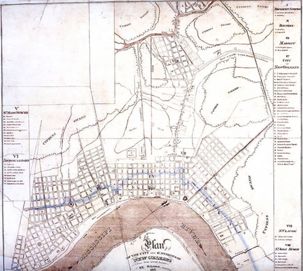
on Mobile Point. Another map of New Orleans in 1816 illustrated the
rural areas with new suburbs created around the nearby plantations (see
Figure B3 in Appendix B).
His elaborate designs were shown on plans for the Lower Garden
District, which crossed five plantations (Soule, La Course,
Annunciation, Nuns and Paris) to include all land up to Felicity Street.
Being a connoisseur of the classics, he gave the streets the names of
the nine muses in Greek mythology: Calliope, Clio, Erato, Thalia,
Melpomene, Terpsichore, Euterpe, Polymnia and Urania. The sophistication
of his plans bore tree-lined canals, fountains, churches, markets, a
grand classical school, and even a coliseum. Most of these decorative
inclusions never materialised, but his grid pattern for the street
layout along with the parks and, of course, the street naming survived.
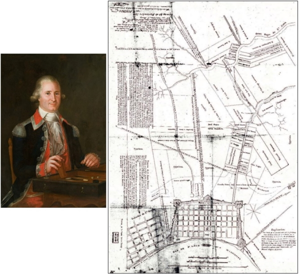
Figure 5: (Left) New Orleans Spanish
Surveyor-General Carlos Trudeau (aka Charles Laveau), and (right) the
1802 map of New Orleans by Carlos Trudeau.
Figure 6: 1802 Lafon map of Lower Louisiana and
Western Florida.
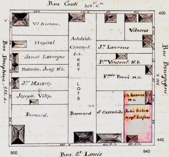
Figure 7: French Quarter Square 91, surveyed in
September 1804 (Lafon Survey Book No. 3, p.46). The allotment shaded
pink is the property acquired by Lafon at the time of this survey, it
being where the house in which he died was located (Edwards and
Fandrich, 2018, p.28).
In 1806 and 1807, he created influential subdivision plans of the
Delord-Sarpy Plantation, enlarging Fauborg St. Mary to resurrect Fauborg
Annunciation further up along the river. In keeping with European style
trends and in departure from the grid street design, he featured
circular designs with radiating streets and diagonal boulevards to
provide vistas together with space for major public buildings. Sections
of the Bywater and Bayou St. John neighbourhoods were designed by Lafon.
Amongst his professional service consultancy were mapmaking, planning
the town of Donaldson in 1806 as well as surveying and advising for
upgrading the fortifications of New Orleans during the War of 1812 and
the Battle of New Orleans in 1815, which saw the end of English
aggression to subvert the young American colonies (Peoplepil, 2023).
Lafon had been recruited as an engineer for the US Army, being a Captain
in the 2nd Regiment of the US Militia of the Territory of Orleans,
preparing many maps for Governor Claiborne during the war.
Lafon was a man of diverse talents. In 1807, he published the first
almanac of New Orleans, “Calendrier de Commerce de la Nouvelle Orleans
Pour l’Annee 1807”, as well as “Annuaire Louisianais Pour l’Annee 1809”
(Edwards and Fandrich, 2018, p.12). Lafon’s contribution to the
redevelopment of New Orleans and the mapping of Louisiana was indeed
“extraordinary”, but his participation in the two wars waged against the
British on his home territory in 1812 and 1815 would seem to have been
overlooked when US President Andrew Jackson evaluated his courageous and
invaluable involvement in defeating a vastly superior (in number, at
least?) British war machine.
Figure 8: One of the earliest and most accurate
maps of Louisiana 1805 by Lafon – Carte Generale du Territoire d’Orleans
Comorenant Aussi la Floride Occidentale et une Portion du Territoire du
Mississippi.
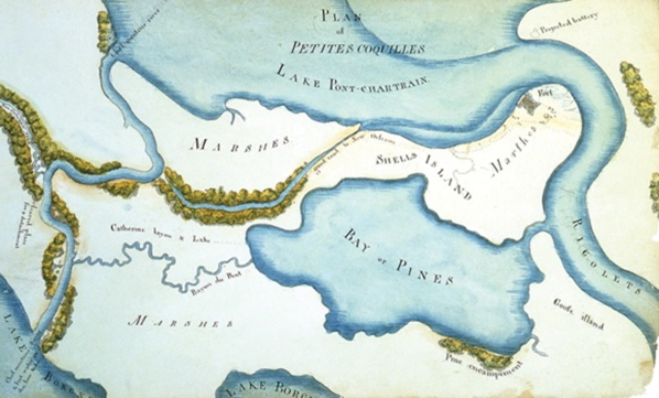
Figure 9: Map of the land around Fort Petites
Coquilles by Lafon, c. 1810 (Masson, 2012).
4. LAFON DURING THE BRITISH WARS AND AS A PIRATE
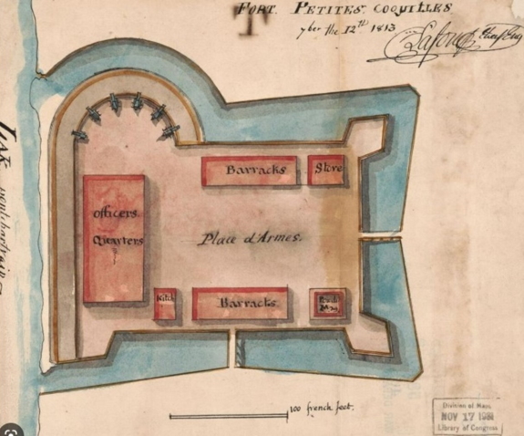
Promoted to Major in the US Militia Engineers, Lafon was able to
improve the defence capabilities at various forts around the territory,
inclusive of Petite Coquilles in 1813 (Figure 10 and Figure B5 in
Appendix B). Officially becoming the State of Louisiana in 1812, the US
became embroiled in the War of 1812 against the militant British Navy
who continually attacked American merchant ships, forcibly pressing
their crews into their own naval service.
Figure 10: Lafon 1813 plan of fortifications at
Petite Coquilles.
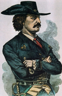
For years, Lafon had a close affiliation with the Laffite brothers,
Jean and Pierre Laffite, who called themselves Baratarian privateers,
operating from the island Barataria in the Gulf of Mexico (Figure 11).
It is quite likely that Lafon had early acquaintances with the pirating
brothers, possibly meeting in Bordeaux, France, before migrating across
the Atlantic to America, or even cooperating during the Haitian
rebellion when many French refugees from that country escaped to the
eastern US. Whenever the first contact was made, there is no doubt that
Lafon had been a close ally of the brothers for a number of years during
which time he plied the seas in his own privateering ship La Carmelita
upon which it is known that a number of liaisons between the three men
ensued. In August 1813, Lafon had the use of a vessel named La Misere,
which hijacked a prize called the Cometa. In 1814, Lafon participated in
an operation leading to the capture of two Spanish vessels, which was
followed by Lafon and others facing indictments for piracy (Guerin,
2010).
After the British had rid themselves of conflict against France, then
forcing Napoleon into exile, they deployed their efforts into razing
Washington DC, in August 1814. The principal target was then the capture
of New Orleans to gain control of the Mississippi River waterway. Facing
a British force of around 9,000 troops, US President/General Andrew
Jackson struck a deal with the leaders of the Baratarian pirate brigade
of some 1,200 individuals, to pardon the recently captured Jean and
Pierre Lafitte plus Lafon along with returning their vessels. Jackson’s
total force of some 5,200 men were able to incur substantial damage on
their opponents, with the British losing three Major Generals (including
Packenham) along with 2,033 soldiers, while only suffering less than 20
casualties (Edwards et al., 2019, p.61).
 |
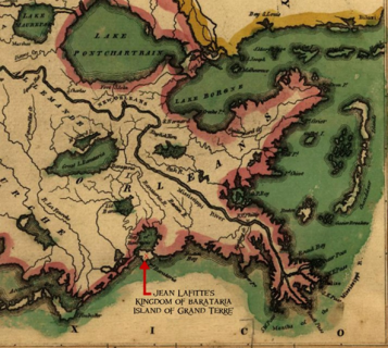 |
Figure 11: (Left) New Orleans privateer Jean
Lafitte, and (right) locality map of the pirate island Barataria in the
Gulf of Mexico which was the stronghold of the looting enterprise.
When the smoke cleared from this war-ending decisive rout, the
back-stabbing US President Jackson reneged on his pledge and held onto
the privateer ships and goods that had been confiscated on the earlier
raid on the pirate stronghold of Grand Terre. Although released from
prison, the two brothers and Lafon remained under close suspicion, and,
while still under US assault, they eventually fled New Orleans
completely (Edwards et al., 2019, p.62). The Lafitte brothers
re-established themselves on the island of Galveston in Texas, for good,
with Lafon joining them during their first two years of resettlement.
Before leaving the pirate stronghold in this new locality, Lafon
still acted as a surveyor for the Spanish government, measuring and
drafting the map “Entrada de la Bahia de Galveston”. He also surveyed
other regions in the southwest, at the same time acting as an official
spy for the Spanish. Duplicity seemed to be the norm for these
buccaneers of the high seas, as it is also firmly believed that Lafon
and the Lafitte brothers acted as double agents, supplying espionage
data to the US administration. The Mexican government in control of
Texas at the time reacted very forcibly when the colony of Mexican
patriots resident on the island conspired with the Lafitte brothers and
Lafon to raid some Spanish ships flying the Mexican flag. After Lafon
couriered a shipment of munitions to Galveston, his ship was seized on
the high seas by agents of the Galveston “government” (Edwards et al.,
2019, p.63).
5. BACK TO NEW ORLEANS IN 1818 AND FINAL DAYS
Having endured enough in Galveston, Lafon was back in New Orleans in
1818. His professional name in surveying and architecture had been
irreparably soiled through his association with the notorious pirate
brothers, his own privateering and the indictment for piracy handed down
by the New Orleans District Attorney, John Dick, in February 1815. After
this, he spent a short stint in gaol before he was finally acquitted
(Edwards et al., 2019, p.62).
Lafon’s choice of returning to New Orleans was more closely related
to his desire to be back with his lifelong love, Modeste Foucher, who
was a free woman of colour, and their four children (Edwards and
Fandrich, 2018, p.11). With minimal success in his attempt to reinstate
his professional career, Lafon attempted to sell all his possessions
with an ultimate desire to return to his homeland where his father and
brother still lived. Starved of work and destitute from Government
Internal Revenue Department fines and costs in defence of the lawsuits
demanding him to repay unpaid duties on the booty plundered from vessels
which were the victims of his daring privateering, Lafon found himself
in a whole world of despair. His halcyon days of brilliant chart making,
skilled surveying and stylish architectural design had deserted him. His
glorious dreams of sailing back to France with his coloured partner and
children, so that they could marry and be free of the discrimination
imposed upon them in the class-conscious New Orleans society, could not
be further away from being realised.
Just when it could not go downhill any further, a yellow fever
epidemic claimed him on 29 September 1820 at the modest age of 51 years.
He died in his home at No. 934-36 St. Louis Street in square 91,
originally purchased in 1804 from the estate of the wealthy woman of
colour, Julie “Betsy” Brion (Figure 12, who was the mother of Modeste
with Joseph Foucher) (Edwards and Fandrich, 2018, p.10). Lafon was
buried in St. Louis Cemetery No. 1 (Figure 13 and Appendix C).
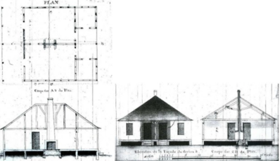
Figure 12: (Left) Lafon architectural plans for
one of his homes at Chef Menteur built in 1806, and (right) 1837
portrait of Julie “Betsy” Brion, from whose estate he bought the land
upon which he erected the house in which he passed away in 1820.
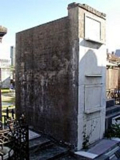
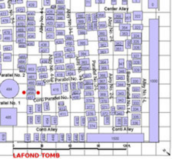
Figure 13: Barthelemy Lafon’s vault in St. Louis
Cemetery No.1 and its locality plan.
6. CONCLUDING REMARKS
The ultimate demise of Barthelemy Lafon from a man of distinction to
a penniless pirate are a sorry tale of riches to rags, finally played
out to the humiliation of his family members, making a fruitless most
lengthy journey from France in pursuit of what was believed to be a vast
estate of land holdings and other investments amounting to an Emperor’s
ransom. His father Pierre Lafon Snr. was in his mid-80s on the long trip
across the Atlantic, but most tragically died not long after his arrival
in 1822, stricken down by the same yellow fever, which had claimed his
son. Next to take the prolonged trip was Lafon’s older brother of 7
years, Pierre Lafon Jnr., accompanied by his 54-year-old wife Jeanne
Victoire. After a mere few days, Jeanne had died of the same deadly
disease, with her husband contracting the fatal fever to pass away in
the following month on 19 October 1822 at the age of 60. The last one
standing from the immediate family was the daughter of Pierre Jnr. and
Jeanne, the spirited Jeanne Philippe Lafon, who was Lafon’s niece. With
the obligatory post-humous inventory of Lafon’s estate the Court of
Probates listing a large portfolio of real estate, over 50 field slaves
and domestic servants, and a library of over 500 books, the extended
journey over the water appeared to offer a mighty inheritance for the
last member to risk death in the epidemic to claim her entitlement!
Pursuing the battle for Lafon’s estate to the Louisiana Supreme Court,
she eventually won, only to hear the court pronounce that the entirety
of Barthelemy Lafon’s estate “was wholly insolvent and unable to pay the
legacies and debts” (Edwards et al., 2019, p.66).
Thus, the fall of Barthelemy Lafon from reputable professional at the
top echelon of the community, to which he made so many invaluable
contributions both physically and financially, can only be the side
effects of his strong allegiance to the notorious plundering Lafitte
brothers, creating a rather unfavourable picture of his activities in
the dubious exploits of privateering, the polite name for condoned
piracy. Whatever image of disrepute may have been associated with Lafon
in his later years, there can be no doubt that his excellence in
surveying, mapping, engineering, architecture and town planning have
survived him, as the brilliance of his European garden design suburbs,
his many stylish and attractive buildings, practical restoration of
roads and flood levees and superb maps of New Orleans and Louisiana
stand in testimony to a complex character of early American history. He
was a hero of the Wars of 1812 and 1815, which saved his territory from
British domination, and his practical solutions with a sharp mind can
only be attributed to his professional training and experience as a land
surveyor.
REFERENCES
- Chamberlain C. and Farber L. (2014) Spanish Colonial Louisiana,
https://64parishes.org/entry/spanish-colonial-louisiana
(accessed Jan 2023).
- Cultural Landscape Foundation (2023) Barthelemy Lafon 1769-1820,
http://www.tclf.org/barthelemy-lafon (accessed Jan 2023).
- Edwards J.D. and Fandrich I. (2018) Surveys in early American
Louisiana: Barthelemy Lafon, Survey Book No. 3, 1804-1806, Report to
the Louisiana Division of Historic Preservation and the Masonic
Grand Lodge, Alexandria, Louisiana,
https://www.crt.state.la.us/Assets/OCD/hp/grants/NPShistoricfunding-2017/FY-2017-2018-Deliverables/Surveys%20in%20Early%20Louisiana%201804-1806%20Barthelemy%20Lafon.pdf
(accessed Jan 2023).
- Edwards J.D., Fandrich I. and Richardson G. (2019) Barthelemy
Lafon in New Orleans 1792-1820, Report to the Louisiana Division of
Historic Preservation,
https://www.crt.state.la.us/Assets/OCD/hp/grants/NPShistoricfunding-2019/Barthelemey%20Lafon%20in%20New%20Orleans_Final.pdf
(accessed Jan 2023).
- Guerin R.B. (2010) Notes on Barthelemy Lafon, Hancock County
Historical Society,
https://www.hancockcountyhistoricalsociety.com/history/notes-on-barthelemy-lafon
(accessed Jan 2023).
- Masson A. (2012) Barthélémy Lafon,
https://64parishes.org/entry/barthlmy-lafon (accessed Jan 2023).
- Peoplepil (2023) Barthelemy Lafon: French architect,
https://www.peoplepill.com/people/barthelemy-lafon (accessed Jan
2023).
- Rawat A. (2018) 10 interesting facts about the Louisiana
purchase of 1803,
https://learnodo-newtonic.com/louisiana-purchase-facts (accessed
Jan 2023).
- Reeves W.D. (2018) Notable New Orleanians: A tricentennial
tribute, Louisiana Historical Society,
https://www.yumpu.com/en/document/read/60393971/notable-new-orleanians-a-tricentennial-tribute
(accessed Jan 2023).
- State of Louisiana (2023) Important dates in history,
https://www.louisiana.gov/about-louisiana/important-dates-in-history
(accessed Jan 2023).
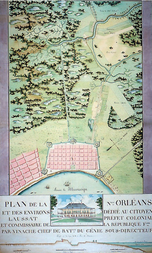
APPENDIX A: PLANS OF NEW ORLEANS
Figure A1: 1803 Vinache Plan De La Nouvelle
Orleans in celebration of France’s short reoccupation of the city before
the Louisiana Purchase Treaty was completed.
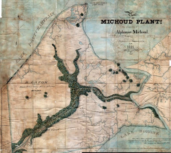
Figure A2: Plan of the easternmost section of
New Orleans by George H. Grandjean titled “Michoud Plantation”, being
the property of Alphonse Michoud comprising 36,056 acres. “B. Lafon” can
be seen printed on the left portion of the plan. Barthelemy Lafon had
gained ownership of this tract of land in 1801, which he used for what
was said to be a “brick plantation”. He lost this holding to creditors
in 1812.
APPENDIX B: PLANS BY BARTHELEMY LAFON & LATER PERSPECTIVE VIEW
Figure B1: 1810 Lafon plan of the mouths of the
Mississippi River
Figure B2: No. 4 plan of the mouth of the
Mississippi, June 1813.
Figure B3: 1816 Lafon plan of the city and
environs of New Orleans.
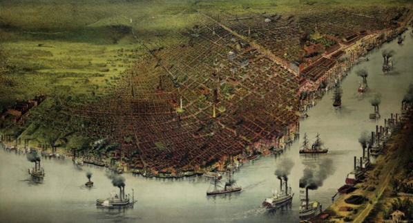
Figure B4: Perspective view of New Orleans and
the Mississippi River from 1885.
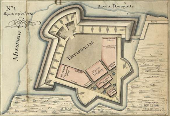
Figure B5: Lafon plan of Fort Balise, 30 May
1813.
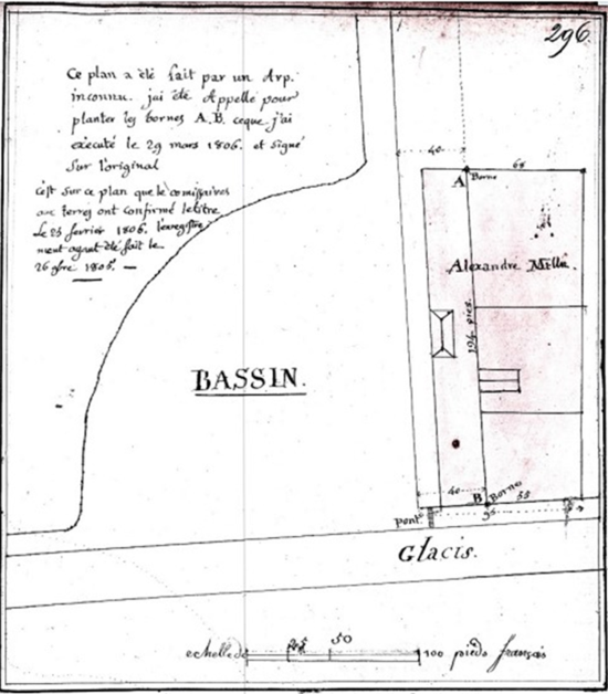
Figure B6: Lafon re-survey of the Carondolet
Canal turning basin and land of A. Milne, 29 March 1806
APPENDIX C: NEW ORLEANS MAP WITH STREET NAMES AND SQUARE SECTION
NUMBERS
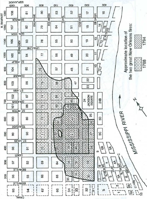
Figure C1: The street pattern of New Orleans
City, showing street names and section numbers as allocated to the
locality descriptions for identification of property, with square 91
being where the house in which Lafon died in 1820 is situated.
Has the article inspired you to get to know more about USA?? Thejn
join us at the FIG Working Week 2023 which will take place in Orlando,
Florida. Read more at:
www.fig.net/fig2023