Article of the
Month - January 2021
|
A Global Survey of Reference Frame Competency
in terms of Education, Training and Capacity Building (ETCB): Results,
Analysis and Update
Ryan Keenan, Australia, Allison Craddock, United States, Mikael
Lilje, Sweden, Rob Sarib, Australia and Graeme Blick, New Zealand
 |
 |
 |
 |
 |
| Ryan Keenan |
Allison Craddock |
Mikael Lilje |
Rob Sarib |
Graeme Blick |
This article in .pdf-format (22 pages)
SUMMARY
Geodetic infrastructure such as continually operating reference
stations are a vital component of reference frames around the world. As
such, a strong foundation of Education, Training and Capacity Building
is essential for ensuring geodetic infrastructure can be established,
maintained and operated correctly, also their data and information
outputs can be processed, analysed and interpreted correctly. In early
2018, the UN-GGIM Subcommittee on Geodesy sought to facilitate a
self-assessment of all member nations' sovereign capabilities to manage
and maintain reference frames. The Subcommittee's working group on
Education, Training and Capacity Building developed an online
Questionnaire seeking feedback specific to Reference Frame Competency.
Response to this survey so far, has been provided by ninety-eight
representatives of Member States and observers across the world. This
paper presents the results of this survey, and offers a brief analysis
of the findings, outlines a summary of the issues and identifies a
number of follow-on tasks for the UN-GGIM Subcommittee on Geodesy and
its working groups to consider when defining the scope of the
forthcoming Global Geodetic Centre of Excellence. Furthermore, linkages
to the Subcommittee on Geodesy Infrastructure Survey will be identified
when appropriate.
1. INTRODUCTION
The Need for a Global Geodetic Reference Frame
Geodesy is an important building block for sustainable development,
the administration and management of land as well as water and other
natural resources interests. Looking forward, geodesy also has the
potential to facilitate the critical access and alignment of the future
of smart societies and their digital economies; in short, geodesy is
playing an increasing role in the lives of people around the world, from
finding directions using a smart phone to alleviating poverty and
ensuring fresh water supplies. Because the Earth is in constant
motion, an accurate point of reference is needed in every country for
making measurements in the country. Geodesy provides a very
accurate and stable coordinate reference frame for the whole planet: a
Global Geodetic Reference Frame.
In February 2015, the United Nations (UN) General Assembly adopted
the resolution “A Global Geodetic Reference Frame for Sustainable
Development” – the first resolution recognizing the importance of a
globally-coordinated and supported approach to geodesy, involving all UN
Member States. Accordingly, the UN Global Geospatial Information
Management (GGIM) Subcommittee on Geodesy (SCoG) is working towards
developing an accurate and sustainable Global Geodetic Reference Frame
(GGRF).
The GGRF Roadmap states that the GGRF is “an authoritative,
reliable, highly accurate, and global spatial referencing
infrastructure. The GGRF includes the celestial and terrestrial
reference frame products and Earth Orientation Parameters (EOPs) that
connect them, the infrastructure used to create it, and the data,
analysis, and product generation systems. The GGRF also includes
gravimetric observations, products and height systems which underpin
measurements of elevation.”
The Subcommittee on Geodesy works within the guidance of the GGRF
Roadmap Implementation Plan and the position paper to define the
appropriate governance arrangements for the GGRF. In alignment with the
Roadmap structure, work is organised into five focus groups, with each
assigned one of the key issue categories of the Roadmap: geodetic
infrastructure; data sharing, policy, standards and conventions;
education, training and capacity building; communications and outreach;
and governance.
The Motivation of Reference Frame Competency
In preparation for the GGRF, the UN-GGIM SCoG sought, to facilitate a
self-assessment of all member nations' sovereign capabilities to manage
and maintain reference frames. The Education, Training, and Capacity
Building (ETCB) Working Group is one of five working groups currently
supporting the SCoG by acting on the Global Geodetic Reference Frame
Roadmap Implementation Plan. As a component of the UN GGIM Subcommittee
on Geodesy, the ETCB Working Group seeks to assess the current
availability of education, training, and capacity building resources,
identify gaps in capacity or other areas of need, and propose short- and
long-term solutions to realize the full scientific and social benefit of
the Global Geodetic Reference Frame. Wherever possible, elements of ETCB
work that are in support of the United Nations Sustainable Development
Goals and/or Sendai Framework for Disaster Risk Reduction are
identified.
The ETCB has developed a five-year strategy (see Appendix 1) with the
vision:
Member States have the capability to develop and maintain state
Global Geodetic Reference frames
and mission
The UNCCIM Working Group on Geodesy sub-committee on capacity
building will coordinate and facilitate capacity building with a
particular focus on regional needs and Member States with less capacity.
The ETCB is tasked with assisting UN Member States build their
capacity and expertise for the intuitive utilization and sustainable
worldwide development of the GGRF, and consequently this assessment
activity. It was hoped that the responses would provide sufficient
insights to determine and collate:
- Current competencies in Reference Frames (RF),
- Future competencies and special interests that are required, and
- Training needs of Member States.
Through its role to lead the development of the questionnaire, the
ECTB wanted to summarise how the audience perceived the capability of
their national geodetic survey organisation (GSO) or agency in terms of
defining, maintaining and operating their national geodetic reference
frame. Accordingly, the questionnaire was designed to assess
Member State RF competency requirements and educational needs, and
comprised of four Sections:
- Information about the Responder and their affiliation,
- Responder’s assessment of current and future RF competency
requirements of their Member State,
- Member State training needs, and
- Other information.
In considering the questionnaire, the ETCB recognised that UN Member
States would have different competency requirements and that all Member
States did not need to reach the same competency level. For example, a
small island state might be a user of the GGRF and thus need competency
in the use of GNSS and connection to the GGRF. A State providing
geodetic infrastructure to support the development of the GGRF might
need capability inVLBI and SLR etc. This led to the initial development
of a matrix defining four levels of RF competency requirements (ETCB,
2018), of which an updated version can be seen in Table 3. It was also
recognised that Member States would be at different levels in their
current skill rating. Another question posed was to consider if there
would be any regional differences in competency requirements, for
example were the requirements in a region of predominantly small island
nations be different from a continental region of Member States.
Given the global nature of the target audience, it was agreed that an
online questionnaire would be the most effective means of gathering
feedback from a geographically diverse target audience. The
Questionnaire was hosted on Google Sheets UN-GGIM SCoG ETCB
Questionnaire – Reference Frame Competency 2018/19
[1] in February 2018, and at time of writing (October 2019) was
still open for feedback after twenty-two months. For the purposes
of this paper, all those responses recorded at the end of October 2019
were included in this evaluation. Feedback from each section of
the questionnaire has been gathered, analysed and presented in summary
form with noteworthy findings and observations, along with a set of
initial proposals.
It must be mentioned that in August 2019, Member States of the
UN-GGIM commended the SCoG on the revised proposal to establish a global
geodetic centre of excellence (GGCE) under the auspices of the United
Nations to help address the critical gaps within the GGRF. The
objectives of the GGCE are to bring about:
- The development and sustainability of geodetic infrastructure
and analysis in Member States through enhanced global cooperation to
ensure an accurate, sustainable and accessible GGRF to which
regional and national Member State reference frames can be aligned.
- Making geodetic data Findable, Accessible, Interoperable and
Reusable (FAIR) so it can be shared globally and used to improve
decision making.
- Meeting Member State long-term geodesy training and capacity
development needs by assessing requirements and developing a
capacity building program based on UN Development Program (DP)
guidelines.
- Improved communications and outreach to describe why geodesy is
important, in particular to policy makers.
Given this development intention around the GGCE, it was clear that
feedback gathered by the ETCB would be extremely valuable in terms of
reflecting an objective large-scale survey of the current status quo of
RF competencies amongst UN Member States.
2. RESULTS – THE RESPONDENTS
This section provides information about the Respondents and their
affiliation. It was hoped to receive feedback from each Member
State’s UN-GGIM Head of Delegation, national agency representatives,
decision-makers, and geodetic community leaders in each State.
A total of ninety-eight responses were received from a total of
sixty-five Member States in the twenty-two months since the first
posting of the survey. The following figures show the country
location of each respondent, and the breakdown of the respondents in
terms of their organisation type, affiliation and role.
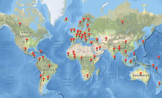
Figure 1 – Locations of the ninety-eight Respondents from sixty-five
Member States to the ETCB RF Competency Survey 2018/19
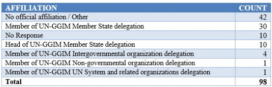
Table 1 – Breakdown of Respondents by
Affiliation
In terms of Affiliation, at least 46% were from UN-GGIM delegations.
Government agencies made up approximately 71% of identified respondents,
with 225 from academic organisations and just 3% from the private
sector.
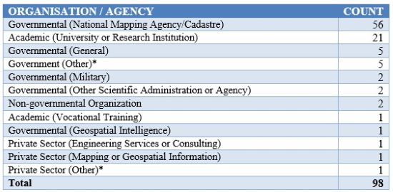
Table 2 – Breakdown of Respondents by
Organisation / Agency Type
Respondents held a wide range of positions with a total of
seventy-eight different titles being provided, covering a comprehensive
range of experiences and responsibilities within their respective
organisations. Several countries were able to provide additional
feedback from multiple respondents, which helps to give more emphasis
and spread on the relevant competencies. Those countries were:
Argentina, Australia, Belgium, Brazil, Burkina Faso, France, India,
Italy, Mali, Marshall Islands, Philippines, Samoa, Senegal, Uganda and
Uruguay.
3. RESULTS – LEVELS OF REFERENCE FRAME COMPETENCY
This section covers the results for the Responders’ assessment of
current and future RF competency requirements of their Member State.
By assessing these, the ETCB expected to be suitably informed to focus
their efforts on helping build targeted training and developing
competency that will benefit each Member State, as well as filling
critical needs for the GGRF.
The following table shows the common competency requirements deemed
necessary for Reference Frames, categorised into four levels, with an
increasing level of competence, knowledge and know-how per level.
Note that this is an ‘evolving’ competency matrix based on questionnaire
responses, and national organisation status reports from around the
world.
This matrix provides GSOs with insight to descriptions of the skills,
experience and knowledge required to build and operate modern geospatial
reference systems and infrastructures (GRSI), along with training and
education requirements, and possible sources to provide the relevant
capability (Sarib, 2020).
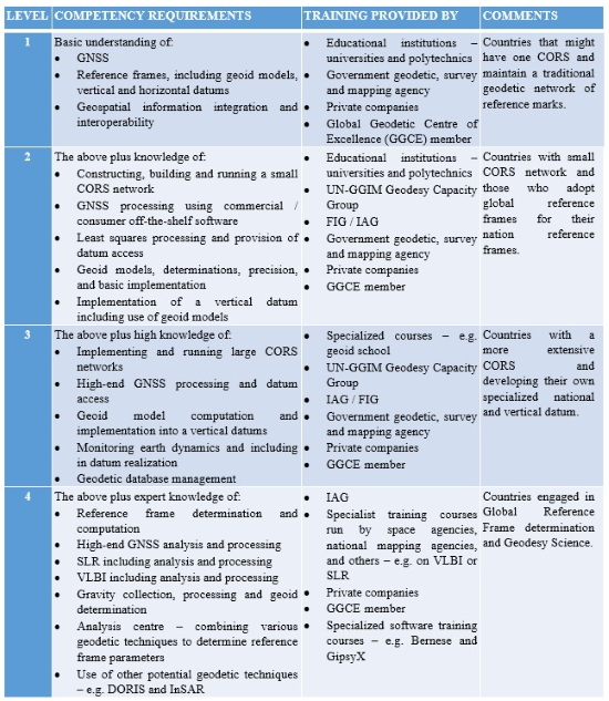
Table 3 – Matrix of Predefined Levels of Reference Frame Competency
requirements (ETCB (2018))
Respondents were provided with this table for reference and invited
to evaluate the sovereign capabilities of their national GSO in terms of
defining, maintaining and operating their national geodetic reference
frame with respect to these levels. In some cases, the respondents
were self-evaluating, i.e. they were from the national mapping/geodetic
agency.
As mentioned earlier, it is worth stating that respondents have
different perceptions not only of the current RF competency level for
their GSO, but also their target level – both of which are highly
dependent on the size, location, topography and tectonic setting of
their Member State (cf. the geodetic requirements of a landlocked nation
on a stable plate might be quite different from a mountainous nation
spanning two tectonic plates).
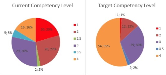
Figure 2 – Pie charts showing the Respondents' feedback on Current
Competency Level (left) and Target Competency Level (right)
Deriving simple statistics on the variances of these parameters, the
mean Current Competency Level is 2.5, and the mean Target Level is 3.4,
clearly suggesting that organisations want to “level up”.
Given the significant number of responses and feedback from developed
and developing nations, there was a considerable spread of ’status quo’
responses. In total, respondents felt that sixteen Member States had
already reached the appropriate level of Reference Frame competency and
required no additional specific training (other than ongoing retraining
and keeping up to date with emerging techniques and technologies). These
countries included: Australia, Argentina, Belgium, Brazil, Chile,
Germany, Finland, France, Hong Kong, Honduras, India, Italy, Japan,
Mali, Netherlands, New Zealand, Norway, Slovenia, Slovakia, Sweden, UK
and USA. It is noted for several of these cumulative national responses,
that there were some variances in assessments of current and future
desired competency. For example, one State provided feedback from three
different respondents – two felt that a Level 4 competency had already
been attained, whereas the third respondent felt that Level 2 was a fair
estimate of both the current and target competency levels for State.
Similar levels of variability were seen across most nations for which
there were multiple respondents. One common takeaway from the majority
of all ninety-eight respondents, was that regardless of whether a higher
level of competency was aspired to or not, they would all have
challenges in maintaining their current and target competencies in all
relevant technologies and techniques as their organisations evolved,
taking into account the typical turnover of staff, budgeting cycles and
in several cases, political priorities. This will be covered more in the
next section.
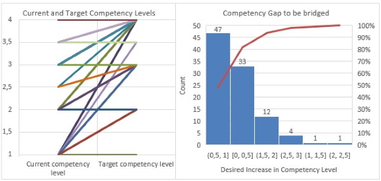
Figur 3 – Breakdown of Current and Future Competency Levels (left)
and Histogram quantifying the Gap in Competency Levels to be bridged
The feedback on Competency level evaluations highlights the
respondents’ subjective needs on how to raise their levels of RF
competency to their target level. An additional request for the
expected duration needed for this improvement was made to bridge the gap
between current and target competency levels, and the results grouped
into bins of four years.
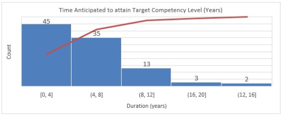
Figure 4 – Time Anticipated to attain Target Competency Level (Years)
One noteworthy observation on the anticipated duration of these
improvements is that the greatest improvement can be achieved within the
timeframe of four years, assuming resources and plans are delivered
successfully and on time. This should be duly noted for future
ETCB activities, by developing short well-defined agendas allowing
organisations to complete them swiftly whilst maintaining progress and
feeling a sense of achievement.
4. RESULTS – TRAINING NEEDS
The next section of the survey went into more detail about what the
respondents felt was required to be able to raise their competencies.
Based on the cumulative experience of the ETCB members who drafted the
survey, a choice of predefined requirements were offered to respondents
in the questions. The following four tables provide summaries of the
questions, their predefined selections and options, along with the
results.
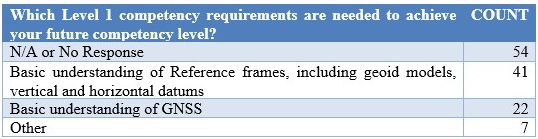
Table 4 – Feedback on Level 1 Competency Requirements
It is noteworthy that while twenty respondents ranked themselves as
being currently at Level 1, there were a larger number of responses for
training on basic understandings of GNSS and Reference Frames. It is
felt that this reflects the ongoing challenges to maintaining core
technical levels in existing and new departments given staff turnover
and personnel resourcing issues.
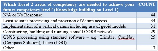
Table 5 – Feedback on Level 2 Competency Requirements
The general trends for required Level 2 competencies:
- A greater number of requests though for training around geoid
models and vertical datums – should be considered in the Proposals
section and by existing regional Capability Development Networks
(CDN) to arrange for additional workshops.
- Training on GNSS CORS networks and associated GNSS processing
software is a constant request.
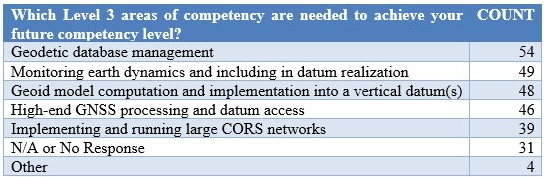
Table 6 – Feedback on Level 3 Competency Requirements
The general trends for required Level 3 competencies:
- More than half of respondents felt that the management of
geodetic databases is a necessary requirement and should be
considered in future workshops. There may be the possibility
to get the private sector involved with this.
- Training on GNSS CORS networks and associated GNSS processing
software is a constant request.A greater number of requests for
training around geoid models and vertical datums – should be
considered in the Proposals section and by existing regional CDNs to
arrange for additional Workshops.
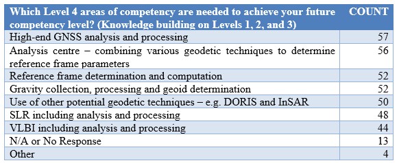
Table 7 – Feedback on Level 4 Competency Requirements
The general trends for required Level 4 competencies:
- Training on advanced GNSS analysis and processing is a constant
request, presumably as GNSS constellations evolve with additional
signals and new receiver technologies.
- Awareness about Analysis centres and their products is of
significant interest.
- A greater number of requests though for training around geoid
models and vertical datums – should be considered in the Proposals
section and by existing regional CDN to arrange for additional
Workshops.
5. FINDINGS.
This section affords a brief analysis of the findings, outlines a
summary of the main issues and identifies a number of follow-on tasks
for the SCoG and its working groups to consider when defining the scope
of the forthcoming GGCE.
Before providing the findings, it is necessary to state some caveats
about the survey results.
- Timing – the window for responding to this
survey was almost two years, so the status quo in some GSOs may have
changed during this time – hopefully for the better.
- Missing Responses – in the situation where
responses were not provided for sections in the questionnaire, the
term ’No Response’ has been included so that a correct statistical
proportion is given in the results.
- Competency Level Grading Subjectivity – these
are self-proclaimed competency evaluations, open to the subjectivity
of each respondent, their overall knowledge, awareness and
experiences, which may not have accurately reflected the true
situation of actual competency levels.
- Agency bias – the type of agency completing the
questionnaire may impact on the answers provided. This was
highlighted by the variation in responses from countries where
multiple responses were received from different agencies.
- Completion – there are a total of one-hundred
and ninety-five Member States, all with the need of GRF, however
this questionnaire was only answered by sixty-five Member States.
Greater participation in this (or a follow-on) survey may occur as
and when the future GGCE is announced.
CHALLENGES
A considerable number of noteworthy observations have been summarised
hereafter which provide a succinct insight of the global challenges
faced by respondents and their respective agencies. Further
details were afforded to the survey, however the essence of the most
common challenges have been distilled in the following sections.
Institutional challenges (typical but no limited to GSOs and
federal organisations)
- Lack of ability (experience / knowledge) and support within the
organisation to justify the establishment and on-going maintenance
of geodetic infrastructure and system.
- No specific and credible mechanisms and frameworks to enable the
sharing of technical knowledge and to support training on the
various aspects of the geodetic data /information cycle
- Lack of categorization of existing technical knowledge and other
resources that may enable intuitive and interoperable use
- The desire to immediately establish a reference frame rather
than learn how to do it; dur to a lack of resources and capability
leading to outsourcing as the preferred option
- Unaware how to and whom to contact in various UN and
international organisations
- Lack of understanding of the strategy, approach, and
requirements to accessing (or even becoming) a regional data
repository or analysis centre
Capacity Building / Training and Education challenges
- The most appropriate person(s) from agency are not always
selected / invited to attend relevant training / workshops etc
- There is often no follow-up or implementation support for those
staff who have attended the appropriate training / capacity
development programs
- There are many “experts or specialists” available to provide
training on core competencies but no system to access or support the
“trainers / educators”
- Many CDN are staffed by international experts volunteering their
assistance beyond their current role, and thus their ongoing
availability is due to the good will of their employer which can be
limited/restricted or unreliable
Barriers to increasing Competencies
- Lack of resources including:
- budget (fiscal and personnel allocation)
- equipment, software, geodetic and supporting infrastructure
(i.e. power, communications)
- socio-political support
- Lack of people with sufficient knowledge, qualifications and
skills, and little consideration of succession planning
- Lack of access to specialists or experts or supervisors in
geodetic surveying
- Lack of training and educational institutes and facilities
- Lack of policies and legislative basis, effecting lack of
support from politicians and decision makers
- Challenges due to multiple open data standards and the
unreliable interoperability of geodetic data globally especially
when GSOs’ core competencies are so different
- Lack of appropriate material to advocate the importance,
achievements and support the justification of modernised GRSI (i.e.
return on investment analysis and statistics, case studies) to suit
the target audience
SOLUTIONS
The following section comprises of direct feedback submitted to the
survey and possible solutions as derived by the authors during analysis.
What training will help the RF competency needs of agencies?
- Improved tertiary education on the fundamentals of surveying
i.e. competencies prior to Level 1
- Increased Level 1 and Level 2 training on geodetic theory and
implementation:
- Determination and computation of Reference Frame parameters;
Height unification and modernisation; Geoid determination;
Network adjustments; Transformation parameters derivation
- Geodetic data management fundamentals and planning
- Clear statement of the requirements to becoming a regional data
repository or analysis centre; and understanding the operations,
services and products
- Establishing, operating and maintaining a GNSS CORS network
- Understanding the techniques / measurements from GNSS, VLBI,
SLR, DORIS, Gravity and InSAR
- Monitoring and measuring the dynamics and deformation of the
earth; dynamic reference frames and datums; implications and
applications; time dependent calculations and models
Resources and Resourcing solutions
- More resourcing, investment, training, scholarships, grants etc.
from internal and external sources – preferably facilitated from a
“centralised” group
- Awareness of funding options and mechanisms – what are they, how
to access, understanding the eligibility criteria and requirements,
and the process to apply
- Succession planning for personnel resources in addition to
regular participation in regional CDN events and workshops
Training and Education solutions
- Increased frequency of regional training to attain a consistent
approach and community spirit
- Consider information exchange seminars on new technologies,
applications and systems that affect GNSS, geodesy and positioning
- Greater recognition and advocacy of geodesy and its benefits to
stakeholders and community
- Courses during the non-academic periods i.e. “summer schools”,
workshops (such as UNOOSA, IAG etc.)
- Make available, easily discoverable, intuitively usable, and
interchangeable training and reference materials, via online
platforms
- Sustainable ways to bridge the knowledge gap and digital divide,
especially in developing countries and/or countries in transitio
- Strategies to encourage more support / effort / assistance from
those geodetic organisations at Level 3 and 4
- Better coordination by the agencies who have possess the
required “levels” and global / regional bodies and global
organisations (i.e. FIG, IAG, UNOOSA et al.)
Sharing and Collaboration solutions
- Share and exchange both resources and data across borders where
possible
- More capacity development to improve sharing of geodetic data –
specifically workshops on the advocating the benefits of sharing,
and development of relevant policy to support implementation
- Develop pathways, structures, frameworks and roadmaps which
facilitates greater collaboration amongst member countries, academic
institutions (including the scientific and research community) and
the commercial sector, to deliver pragmatic and fit-for-purpose
solutions
- Facilitate greater collaboration and engagement, and investigate
alternate sources of resources, in particular the private sector and
independent experts who can assist
Increased Regional Involvements
There are several examples where ongoing regional initiatives have
demonstrated moderate success. One such example is how the FIG
Asia Pacific Capability Development Network (FIG AP CDN) and its
enduring collaboration with the ETCB in Asia and the Pacific region.
Participants from these groups have run and contributed to a significant
number of successful reference frame in practice workshops since 2013,
helping to:
- Provide advice on the importance of strategic and operational
planning to develop geodetic and geospatial communities, in this
instance across Pacific Island Country Territories (PICTs).
- Advocated the role and value of geodetic and geospatial
information to resolving and managing the impacts of climate change
/ sea level rise, and natural disasters such as cyclones,
earthquakes and tsunamis.
A significant /common theme for workshops run by AP CDN is into the
education, planning and maintenance of GNSS CORS infrastructure
capability and geodetic datum modernisation activities.
International Federation of Surveyors (FIG) Commission 5 has a
well-known and industry recognised workshop entitled ‘Reference Frames
in Practice (RFIP)’ that has been run numerous times alongside
conferences, workshops and other geospatial events, not only those
organised by FIG. Further information on the FIG AP CDN and its
involvement can be found at
https://www.fig.net/news/news_2019/11_ap_cdn.asp
One further observation was that most organisations would benefit
from receiving an independent holistic evaluation of their current
competencies with specific objective focus on achieving their target
competencies with respect to their strategic roadmap and vision.
6. SUMMARY AND RECOMMENDATIONS
Based on the collective analysis and weighting of survey responses,
there are four significant points that must be considered to
successfully build capacity for the GGRF:
- There is a very strong interest or need to continue to build
capacity for geodetic reference frame competency, especially in
those developing countries with limited resources.
- There is a very strong argument for continued contribution of
developed countries to support these developing countries at the
global, regional and national level.
- There is an increasing demand for a global facilitator of ETCB
to help collate requests, arrange resources such as trainings,
in-country workshops, technical reviews etc. This entity
should also be responsible for ensuring stronger coordination and
sustainable collaboration between those existing
groups/organisations who currently provide these resources and could
do so in the future.
- Finally, this survey generated considerable objective feedback
and insight for those forming the GGCE, its structural organisation,
its objectives and the obligations that it must assume for it to
truly deliver benefit and sustainable long-term impact.
The overall challenge for geodetic organisations is to ensure that
priority capacity building commences and becomes continuous; to do so,
the following recommendations are given.
RECOMMENDATIONS
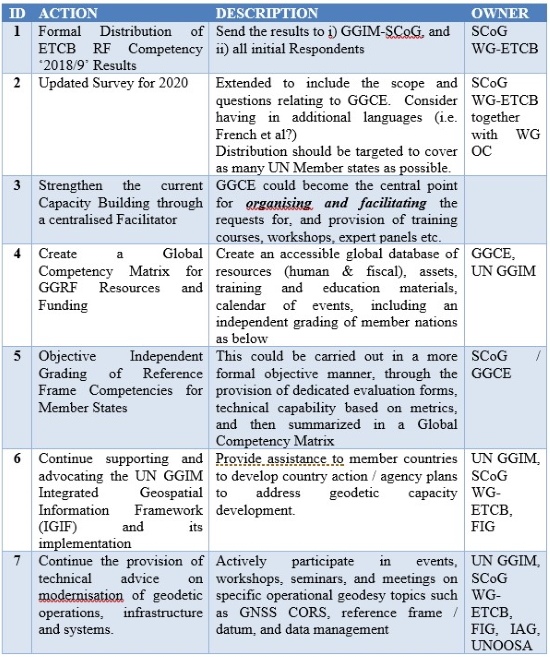
Table 8 – Recommendations for ongoing ETCB activities on raising the
level of Global Reference Frames Competency
The UN-GGIM SCoG, together with the global geodetic community, can
overcome the common challenges and accelerate to higher levels of RF
competency by facilitating the necessary mix of training, exposure,
collaboration and knowledge transfer.
As quoted earlier during one of the objectives for the GGCE - ‘Making
geodetic data Findable, Accessible, Interoperable and Reusable (FAIR)
…’; the authors feel that the GGCE should ensure that training and
education be treated in a similar manner with the following objective:
- Making education, training and capacity building Findable,
Accessible, Interoperable and Reusable (FAIR) so it can be shared
globally and used to improve decision making.
Ultimately, the successful establishment of the GGCE as proposed by
the UN-GGIM SCoG would be best positioned to deliver, implement and
facilitate an enhanced, fit-for-purpose and globally sustainable
capacity building initiative for ongoing GGRF education and
training.
ACKNOWLEDGEMENTS
The authors would like to acknowledge the following:
- Those involved with drafting and defining this questionnaire in
early 2018, with notable thanks going to Allison Craddock and Graeme
Blick, for their efforts on driving the initial questionnaire’s
delivery and creating the initial four-level competency matrix
respectively,
- Respondents for their time, constructive feedback and
contribution to the survey, and'
- Groups involved with UN-GGIM SCoG working to realise the vision
of the GGCE.
REFERENCES
ETCB (2018), Reference Frame Competency Survey [online at Google
Documents], Available at:
https://docs.google.com/forms/d/128LHyUCYsXRn9hQSdtGGa54XniAVPRjeRws3e0Dva9o/viewform?ts=5d9e42bf&edit_requested=true
[Accessed 10 Jan 2020].
FIG Asia Pacific Capacity Development Network – Reports &
Presentations [online] Available at:
http://www.fig.net/organisation/networks/capacity_development/asia_pacific/index.asp
[Accessed 10 Jan 2020].
Global Geodetic Reference Frame [online] Available at:
http://www.unggrf.org/ [Accessed 10
Jan 2020].
GGRF Roadmap Annex 1, Glossary of Terms [online], Available at:
http://ggim.un.org/meetings/GGIM-committee/documents/GGIM6/E-C20-2016-4%20Global%20Geodetic%20Reference%20Frame%20Report.pdf
[Accessed 10 Jan 2020].
Sarib, R (2020) “Capacity Development Program for a Modernised
Geodetic Framework”. Proceedings FIG Working Week, Amsterdam, The
Netherlands.
United Nations Global Geospatial Information – Subcommittee on
Geodesy [online] Available at:
http://ggim.un.org/UNGGIM-wg1/
[Accessed 31 Dec 2019]
United Nations Global Geospatial Information – Subcommittee on
Geodesy Newsletter #10 November 2019 ‘Global Geodetic Centre of
Excellence (GGCE) – A new benchmark for global geodesy’ [online],
Available at:
https://www.unggrf.org/UN-GGIM_Newsletter_10-2019.pdf [Accessed 10
Jan 2020]
UN GGIM (2018a), “Integrated Geospatial Information Framework - A
Strategic Guide to Develop and Strengthen National Geospatial
Information Management Part 1: Overarching Strategic Framework”, United
Nations Global Geospatial Information Management.
UN GGIM (2018b), “Integrated Geospatial Information Framework - A
Strategic Guide to Develop and Strengthen National Geospatial
Information Management Part 2: Implementation Guide”, United Nations
Global Geospatial Information Management.
BIOGRAPHICAL NOTES
Dr. Ryan KEENAN, since completing his PhD in GPS,
Geodesy & Navigation (University College London), Ryan has over twenty
years of GNSS positioning industry experience initially with specific
focus on high-precision applications for the survey, geodesy, machine
control, agriculture and mining sectors. More recently, in his
role as Principal Consultant at Positioning Insights, Ryan has been
providing independent advice on location technologies to governments and
numerous SMEs across the Asia Pacific and Oceania regions. Dr.
Keenan is currently co-Chair of FIG Commission 5’s Working Group 4 on
‘GNSS’, a member of the FIG Asia Pacific Capacity Development Network
and member of two UN GGIM Subcommittee on Geodesy Working Groups –
Education, Training and Capacity Building, and Outreach & Communication.
Allison CRADDOCK is a member of the Geodynamics and
Space Geodesy Group in the Tracking Systems and Applications Section at
the NASA Jet Propulsion Laboratory in Pasadena, California, USA. She is
the director of the International GNSS Service (IGS) Central Bureau,
manager of external relations for the International Association of
Geodesy’s Global Geodetic Observing System and staff member of the NASA
Space Geodesy Program.
Mikael LILJE, Manager of International Department at
Lantmäteriet (the Swedish mapping, cadastral and land registration
authority). Mikael has been working at Lantmäteriet since 1994
mainly at the Geodetic Infrastructure Department where he was the
manager between 2009 and 2019. In his current position he is responsible
for the international services that Lantmäteriet is involved in, mainly
in Africa and Eastern Europe. He is also supporting Lantmäteriet’s
management team with international cooperation on UN, Global, European
and Nordic level. Mikael is currently leading the Working Group on
Education, Training and Capacity Building within the UN GGIM Sub
Committee on Geodesy. Mr. Lilje has been an active member of the
FIG since 1998 and is now FIG vice President.
Rob SARIB, Director Survey / Surveyor-General, in
the Land Information Group of the Northern Territory Government of
Australia’s Department of Infrastructure Planning and Logistics. Rob
Sarib obtained degree in Bachelor Applied Science – Survey and Mapping
from Curtin University of Technology Western Australia in 1989. He also
holds a Graduate Certificate in Public Sector Management received from
the Flinders University of South Australia. Rob was registered to
practice as a Licensed Surveyor in the Northern Territory, Australia in
1991. Since then he has worked as a cadastral and geodetic surveyor, and
a land survey administrator. Mr. Sarib has been an active member of the
FIG since 2002, and is now Chair of the FIG Asia Pacific Capacity
Development Network. He is presently a Board member of Surveying and
Spatial Sciences Institute; the Chair of the Surveyors Board of Northern
Territory; and member of the Inter-governmental Committee on Survey and
Mapping – Australia.
Graeme BLICK obtained his Bachelor of Surveying from
Otago University in 1980. He worked for GNS Science before
spending time at the University NAVSTAR Consortium in Boulder Colorado
utilising GPS to monitor crustal movements on several international
projects. In 1995 he moved to Land Information New Zealand (LINZ),
New Zealand’s National Survey and Mapping agency. He is the Chief
Geodesist and Group Manager of the Positioning and Resilience Group
where he continues to work on and manage the development and
implementation of the geodetic system in New Zealand and develop a new
resilience programme of work for LINZ.
CONTACTS
Dr. Ryan KEENAN
Positioning Insights
Melbourne, Victoria
AUSTRALIA
Tel. +61-476-688-117
Web site:
www.positioninginsights.com.au
Ms. Allison CRADDOCK
NASA Jet Propulsion Laboratory
4800 Oak Grove Drive, MS 238-600
Pasadena, CA 91109
USA
Mobile: +1 818 237 0425
Web site: www.jpl.nasa.gov
Mr. Mikael LILJE
LANTMÄTERIET – International Department
801 82 Gävle
SWEDEN
Tel: +46-026-63 37 42 | Mob: +46 70 2089571
Web site:
www.linked.com/company/lantmateriet |
www.facebook.com/lantmateriet
Mr. Rob SARIB
Department of Infrastructure Planning and Logistics
GPO Box 1680
Darwin NT
AUSTRALIA
Tel. +61 8 8995 5360
Web site: https://dipl.nt.gov.au/
Mr. Graeme BLICK
Land Information New Zealand
PO Box 5501
Wellington 6145
NERW ZEALAND
Tel. +64 27 4528769
Web site: https://linz.govt.nz


