ABSTRACT
Only 1.5 billion of the estimated 6 billion land parcels world-wide
have land rights formally registered in land administration systems.
Many of the 1.1 billion slum dwellers and further billions living under
social tenure systems wake up every morning to the threat of eviction.
These people are the poor and most vulnerable and have reduced forms of
security of tenure; they are trapped in poverty. Increasing global
population and the rush to urbanisation is only going to turn this gap
into a chasm.
This paper explores one potential solution to the security of tenure gap
through establishing a partnership between land professionals and
citizens that would encourage and support citizens to directly capture
and maintain information about their land rights. The paper presents a
vision of how this might be implemented and investigates how the risks
associated with this collaborative approach could be managed.
1. INTRODUCTION
Land Administration Systems (LAS) provide the formal governance
structures within a nation that define and protect rights in land,
including non-formal or customary institutions. Their benefits range
from guarantee of ownership and security of tenure through support for
environmental monitoring to improved urban planning, infrastructure
development and property tax collection. Successful land markets depend
on them.
Despite this pivotal support of economic development, effective and
comprehensive LAS exist in only 50 mostly western countries and only 25
percent of the world’s estimated 6 billion land parcels are formally
registered in LAS. This leaves a large section of the world’s population
with reduced levels of security of tenure, trapping many in poverty.
Missing and dysfunctional LAS can precipitate problems such as conflicts
over ownership, land grabs, environmental degradation, reduced food
security and social unrest. Rapid global urbanisation is exacerbating
these discrepancies.
This security of tenure gap cannot be quickly filled using the current
model for registering properties that is dominated by land
professionals. There are simply not enough land professionals
world-wide, even with access to new technologies. To quickly reduce this
inequality we need new, innovative and scalable approaches to solve this
fundamental problem. This is one of our fundamental global challenges.
This paper explores one potential solution to the security of tenure
gap: ‘crowdsourcing’. Crowdsourcing uses the Internet and on-line tools
to get work done by obtaining input and stimulating action from citizen
volunteers (www.crowdsourcing.org). It is currently used to support
scientific evidence gathering and record events in disaster management,
as witnessed in the recent Haiti and Libya crises, for example. These
applications are emerging because society is increasingly spatially
enabled. Establishing such a partnership between land professionals and
citizens would encourage and support citizens to involve themselves in
directly capturing and maintaining information about their land rights.
Although citizens could use many devices to capture their land rights
information, this paper advocates the use of mobile phone technology.
Due to high ownership levels (5 billion licenses world-wide) and
widespread geographic coverage (90 percent of the world’s population can
obtain a signal), especially in developing countries, mobile phones are
an excellent channel for obtaining crowdsourced land administration
information. Frugal innovation is making them affordable for all,
especially in developing countries where a new generation of information
services in health and agriculture, for example, is turning the mobile
phone into a global development tool.
Mobile phones are progressively integrating satellite positioning,
digital cameras and video capabilities. They provide citizens with the
opportunity to directly participate in the full range of land
administration processes from videoing property boundaries to secure
payment of land administration fees using ‘mobile’ banking. But even
today’s simpler phones offer opportunities to participate in
crowdsourcing.
A key challenge in this innovative approach is how to ensure
authenticity of the crowdsourced land rights information. The paper
explores applicability of the approaches adopted by wikis (a piece of
server software that allows users to freely create and edit Web page
content using any Web browser), e-commerce and other mobile information
services and recommends the initial use of trusted intermediaries within
communities, who have been trained and have worked with local land
professionals. This approach has the potential to provide a good level
of authenticity and trust in the crowdsourced information and would
allow a significant network of ‘experts’ to be built across communities.
To optimise the scarce resources, these intermediaries could be involved
in a range of other information services, such as health, water
management and agriculture.
2. ARE CURRENT LAND ADMINISTRATION SYSTEMS DELIVERING THE EXPECTED
BENEFITS?
Despite the clear link between effective LAS and efficient land
markets (Al- Omari, 2011), sustainable development and the other
benefits, their current adoption and effective implementation are
limited to about 50 and found mainly in western countries and in
countries in transition in central Asia (Enemark et al, 2010). A number
of factors limit their scope of implementation:
- Costs are significant and national solutions can take from five
to over 20 years to implement.
- Overly complex procedures lead to high service delivery costs
and end user charges, excluding the poor and the vulnerable.
- Lack of a supporting land policy framework ensures that the LAS
do not deliver against the main drivers of land tenure, land markets
and socially desirable land use.
- Insufficient support for social and customary tenure systems
excludes large proportions of the population.
- Lack of transparency encourages corruption in the land sector,
lowering participation through lack of trust.
- Communication channels to customers are either office or
Internet based and lead to geographic discrimination or exclusion
through the ‘digital divide’.
- A mortgage requires a bank account and credit rating, which is
difficult for the poor and those remote from financial services to
obtain.
- Cadastral surveys using professional surveyors are normally
mandatory and generate higher fee rates, e.g. in the USA a typical
residential land parcel costs $300 -$1,000
(http://www.costhelper.com/cost/home-garden/land-surveyor.html) to
survey depending on local rates and the size and type of parcel.
It is estimated that there are around 6 billion land parcels or
ownership units world-wide. 4.5 billion parcels are not formally
registered and of these 1.1 billion people live in the squalor of slums.
With urbanisation predicted to increase from the current 50% to 60% in
2030 and a further 1 billion being added to the world’s population in
this timeframe, the security of tenure gap will become a chasm. This
will be impossible to fill in the foreseeable future using the currently
available land administration capacity. The International Federation of
Surveyors (FIG) currently represents 350,000 land professionals
world-wide. The current LAS paradigm cannot be scaled up quickly enough
to meet the demand.
The lack of effective, affordable and scalable LAS solutions conspires
to limit access to land administration services by large sections of
society, especially the most vulnerable, leaving them trapped in
poverty. There is a pressing need to radically rethink LAS: simplify
procedures, reduce the cost of transactions, and open new channels for
participation. Crowdsourcing through ubiquitous mobile phones, for
example, offers the opportunity for land professionals to form a
partnership with citizens to create a far-reaching new collaborative
model and generate a set of LAS services that will reach the world’s
poor. The rest of this paper explores how citizens can be empowered to
support the delivery of LAS services through crowdsourcing.
3. A NEW CITIZEN COLLABORATION MODEL FOR LAND ADMINISTRATION
This section provided a vision of how citizens armed with mobile
phones, with the help of land professionals, could effectively capture
and manage their land rights.
3.1 The Increasingly Pervasive Mobile Phone
Although citizens can provide their crowdsourced data through a
number of traditional channels, including paper, mobile phones are
progressively proving to be the device of choice. Mobile phones have
made a bigger difference to the lives of more people, more quickly, than
any previous communications technology. They have spread the fastest and
proved the easiest and cheapest to adopt. In the 10 years before 2009,
mobile phone penetration rose from 12 percent of the global population
to nearly 76 percent. It is estimated that around 5 billion people
currently have mobile phones and 6 billion will have them in 2013
(http://www.itu.int/ITU-D/ict/statistics/)
Recently the fastest growth has been in developing countries, which had
73 percent of the world’s mobile phones in 2010, according to estimates
from the International Telecommunications Union
(http://www.itu.int/ITU-D/ict/statistics/). In 1998, there were fewer
than four million mobiles on the African continent. Today, there are
more than 500 million. In Uganda alone, 10 million people, or about 30
percent of the population, own a mobile phone, and that number is
growing rapidly every year. For Ugandans, these ubiquitous devices are
more than just a handy way of communicating: they are a way of life
(Fox, 2011). Not all phones in the developing world are in individual
use, but are actually used as a communal asset of the household or
village.
Due to their high ownership levels and widespread geographic coverage,
especially in developing countries, mobile phones are therefore an
excellent channel for obtaining crowdsourced land administration
information. But are they affordable and do they have the necessary
functionality?
3.2 The rise of smart phones and tablets
Telecommunications has developed exponentially. Phones have changed:
there is a big shift from holding a phone to your ear to holding it in
your hand. Smart phones have emerged that are able to browse the web,
send and receive email, and run applications - as well as storing
contacts and calendars, sending text messages and (occasionally) making
phone calls. See figure 1 for the range of Cyborg (an organism that has
enhanced capabilities due to technology) functionality provided by smart
phones. Smart phones represented 24 percent of all mobiles sold
worldwide in the first quarter 2011 – up from 15 percent a year before.
The tipping point when they make up 50% may only be a year or so away.
Although smart phones may cost around US$600 today, volume of sales and
frugal innovation will drive the cost down to an estimated US$75 in
2015. A US$100 smartphone has already arrived on the streets of Nairobi.
Before the end of the decade, every phone sold will be what we'd now
call a smartphone and cost US$25 (Arthur, 2011).
Although smart phones have combined an array of technologies onto the
mobile phone platform to significantly increase its functionality and
its applicability in a wide range of new applications, regular mobile
phones can still be used to support information services and gather
crowdsourced information, through text messaging services (SMS) for
example.
The emergence of tablets is also providing an opportunity for
effectively supporting crowdsourced information, especially graphical
information. This technology will play a significant role in the future
of crowdsourcing.
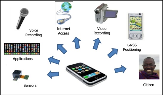
Figure 1: Smart Mobile Phone
Cyborg Functionality
3.3 Vision of an effective crowdsourced Land Administration
solution
This increase in functionality of the mobile phone, its migration to
lower cost devices through frugal innovation, its increasing
pervasiveness across developing countries and its connection to Internet
and information services is opening up significant opportunities for its
use in delivering more effective and accessible land administration
services. The possibilities are explored below:
Accessing Customer Information Services - A whole new generation of
innovative information services, such as agricultural and health, are
being provided to users of mobile phones in developing countries. A good
example is the use of mobile phones to record and transfer water quality
or water source inspection data from the field to a central database
where water sector professionals can then view the data collected and
identify hazardous water sources
(www.bristol.ac.uk/aquatest/about-project/workplan/ma6/). A similar set
of land administration services for users could provide explanations of
procedures, electronic forms for completion, standard applications and
best practice for land registration and cadastre, for example. This
remote guidance and support will be essential when there is more
significant citizen participation in land administration services and
could be provided by tiers of citizen intermediaries with guidance by
Land Professionals.
Recording Land Rights - The mobile phone will allow citizens to directly
record the boundaries of their land rights. This can be achieved in
several ways:
- Marked up paper maps digitally photographed with the phone.
- A textual description of the boundaries recorded on the phone.
- A verbal description recorded on the phone.
- Geotagged digital photographs of the land parcel recorded on the
phone.
- A video and commentary recorded on the phone – this could
include contributions from neighbours as a form of verification
(mobile phone numbers of neighbours could be provided).
- The positions of the boundary points identified and recorded on
imagery using products such as Google Maps and Bing, for example.
- The co-ordinates of the boundary points recorded directly using
the GNSS capability of the phone.
In all cases the authenticity of the captured information would be
enhance by passively recording the network timestamp at time of capture.
This information is not something that most (99.999%) of users can
tamper with.
The results of this crowdsourced or self-service information could then
be submitted electronically to either the land registration and
cadastral authority or open data initiative for registration. Although
there are limitations in the quality and authenticity of the ownership
rights information provided, it could form the starting point in the
continuum of rights (UN-HABITAT, 2008) being proposed by UN-HABITAT.
This recognises that rights to land and resources can have many
different forms and levels.
To increase the authenticity and quality of the registration
application, the concept of the ‘Community Knowledge Worker’ created by
the Grameen Foundation (Donovan, 2011) could be adopted. The ‘Community
Knowledge Workers’ are trained members of communities supporting
agricultural and health information services who act as trusted
information intermediaries to those who have limited skills and access
to information. A similar model could be used for crowdsourced land
administration services to record or check ownership rights prior to
their submission. In fact, the ‘Community Knowledge Workers’ model could
be extended to also support land administration information services.
This model is similar to the administrative roles of the Patwari in
India and the Lurah in Indonesia.
This engagement of local communities is also being highlighted as a key
success factor by crisis mapping projects. They realise that without
community buy-in, the valuable crisis mapping tools will not be used.
Communities must be engaged at all stages of the project and technical
design to ensure that crisis mapping efforts are in line with local
incentives and capacities. For example, this community led approach
brought fourteen organisations into a network in Liberia contributing
data to a multi-layered map that served as a central nervous system for
early warning signs of conflict in the run up to the national elections
in 2011 (Heinzelman et al, 2010).
When the captured land rights are submitted to the property register
(see section 4 for a discussion on an alternative shadow property
register based on an open data initiative) a variety of quality checks
could be applied to the submitted information, including: random checks
in the field; comparisons with other applications submitted in the same
proximity; checks on ownership of the mobile phone; review evidence for
the location of its owner through the log showing that the phone is
frequently used within a location; network time stamping of captured
information; and contact the client and their neighbours on their mobile
phones to ask for clarification. Further details of approaches to
managing the authenticity risk are contained in section 5 ‘Managing the
Risks’.
Obtaining Title - The submission of an application for registration
usually involves the payment of a fee. This is normally paid as cash
over the counter or a financial transaction through a bank or post
office. However, in the context of mobile phones, the payment could be
made by the client through ‘mobile banking’ on the mobile phone.
Mobile phones are currently being used to manage identification
information. In Finland chip ID cards for government employees are being
adopted throughout Finnish central government. It is therefore feasible
that encrypted forms of land title could be incorporated into clients’
mobile phones and used as proof of ownership.
Accessing Land Information - Effective LAS are supported by Land
Information Systems. These are initially developed to support the
internal operations of the land registration and cadastral authority.
However, the next development stage is to make them outward facing and
accessible by customers either by Extranet or Internet. However, with
mobile phones directly supporting Internet access, these information
services can now be accessed by mobile phones. This new channel, which
will be the only access to the Internet for many countries, creates much
more accessibility for the citizen, bringing land administration
services to a wider range of society, many of whom are currently
excluded.
Paying Mortgage Instalments - Securing a mortgage normally requires the
property owner to have a bank account to support the mortgage payments
transactions. However, the mobile phone offers opportunities to provide
secure payment of land administration fees with the increasing use of
‘Mobile Banking,’ simplifying the procedures and again potentially
opening up the means of wider property ownership.
4. IMPACT OF NEW CITIZEN COLLABORATION MODEL ON THE EXISTING LAND
ADMINISTRATION SECTOR
The introduction of this new LAS model will likely be perceived by
most land professionals working in the land administration sector as
radical and by some as a serious threat. However, the current generation
of mobile phones and other devices are increasing the potential range of
participants in land administration. We are seeing the rise of the
‘proamateur’, somewhere between the professional and the amateur, caused
by this easy to use and accessible technology. Disruptive technology has
caused professional realignments in the past: total stations allowed
surveying technicians to perform more tasks, more accurately than
before. Crowdsourcing by ‘proamateurs’ is not a risk to land
professionals, but allows a wider range of participants to be involved
in land administration and more quickly address and solve our global
challenges.
Land professionals’ attitudes towards this new model will determine how
land administration is shaped in the future. Here are two scenarios of
the potential impact of the new model on the land administration sector.
Rejection by Land Professionals: Shadow Property Register - In countries
where there is little citizen trust in poorly performing or corrupt land
administration services provided by the government, an alternative
property register may be created through crowdsourcing. This ‘shadow’
property register would be similar to the OpenStreetMap crowdsourced
model that has successfully provided an alternative source of mapping
for many countries. An ‘OpenCadastralMap’ (Laarakkar and de Vries, 2010)
or ‘OpenLandOwnership’ open data initiative would emerge. Despite not
having the usual endorsement and guarantee from government, its
legitimacy may progress over time as quality and trust evolve. It may
even be embraced by the informal market as a trusted repository to
support transactions more affordably and effectively than the formal
property register. The real test will be if financial services use it to
judge risk in the mortgage market. Ultimately, it may either replace the
government land administration service, reinforcing the informal land
market, or be adopted by government once it has reached a critical mass
and quality.
Acceptance by Land Professionals: Supplement to the Formal Property
Register - Other countries may embrace this new model as an opportunity
to accelerate the number of properties being registered across the
country and support a much more inclusive solution to land
administration. If land professionals work in partnership with citizens
and communities and grow a network of trusted citizens to record and
register land rights then this source of land information could be
managed directly by the formal property registers. Initially these
crowdsourced records could have a provisional status that would be
formalised following checks on authenticity. This could be performed
directly by land administration staff or accepted directly from trusted
community experts or quality checks achieved through crowdsourcing. The
approach to and judgement of authenticity would evolve and improve over
time, just as has happened with the maintenance of all wikis. This would
involve a changing role for land professionals, working with citizens
rather than for citizens.
In emerging nations where there are insufficient land surveyors or land
surveyors do not wish to embrace a crowdsourced approach, the lawyers,
assessors or even bankers may eventually try to remove or at least
reduce the need for land surveyors in the property transaction by either
resorting to direct crowdsourcing or identifying another type of
intermediary to facilitate crowdsourcing in different communities in
exchange for some cash or in-kind consideration.
5. MANAGING THE RISKS
As with all radical changes to long standing approaches, vested
interests will be jeopardised and entrenched opposition will inevitably
be encountered. Here are some of the risks that will most likely be
raised to attempt to keep the status quo.
5.1 Can crowdsourced land rights information be sufficiently
authenticated?
One of the most contentious issues surrounding crowdsourced
information is the authenticity or validity of the information provided.
Without the rigors and safeguards associated with formal professional
and legal based processes, crowdsourced information is of variable
quality and open to potential abuse. Crowdsourced information has
provided input to wikis, feedback of quality of services and counting
birds, for example, but is not normally used to capture information as
critical and legally binding as property rights in an authoritative
register. So what techniques could be used to quality assure the
authenticity of the information to a level that would be acceptable for
inclusion in a property register? Some alternatives, including lessons
learned from leading wikis and e-commerce, are discussed below. However,
the most appropriate crowdsourcing approaches to authenticity assessment
will only be identified through testing in the field.
Grameen Community Knowledge Workers as Intermediaries
This approach would avoid open, direct crowdsourcing at the outset and
only allow information to be provided by trusted intermediaries within
communities who have been trained and have worked with local land
professionals. Initially, there would be comprehensive quality assurance
of the crowdsourced information, but over time as trust is established
with the intermediaries the level of quality assurance sampling could
significantly decrease. These initial intermediaries could then train
further experts to build a significant network of ‘experts’ across
communities. Each expert would be continually checked and appraised to
determine the level of expertise and trust in the associated
crowdsourced information. To optimise the scarce resources, the
intermediaries could be shared with a range of information services,
such as health and agriculture.
Community based Quality Assurance
Quality assurance could be directly provided by members of the local
communities who take direct responsibility for authenticity. The
crowdsourced land right claims could be posted for communities to review
and comment on. Some form of local or regional land tribunal could be
established to arbitrate on conflicting claims. Once a critical mass of
land rights information is obtained it is then easier to identify
anomalies and conflicting claims. Levels of trust and accuracy of the
land rights would be upgraded over time as more evidence and cross
checking validates the claims.
Wiki and e-Commerce Solutions
Beyond local involvement in quality assurance, a centralised user
reputation system based on feedback from crowdsourced registrations,
similar to the buyers’ ratings of the sellers used in eBay, could be
used to assess the credibility of contributors and the reliability of
their contributions (Coleman, 2010). Leading wikis, such as
Wikipedia.org, originally relied solely upon the "wisdom of the crowds"
to evaluate, assess and, if necessary, improve upon entries from
individual contributors, usually with great success. However, recent
contributions of deliberate misinformation to specific entries have
caused Wikipedia to re-assess its approach. Beginning in December 2009,
it has relied on teams of editors to adjudicate certain "flagged
entries" before deciding whether or not to incorporate a volunteered
revision (Beaumont, 2009).
Although the data that are contributed to VGI projects do not comply
with standard spatial data quality assurance procedures and the
contributors operate without central co-ordination and strict data
collection frameworks, research of VGI is starting to provide methods
and techniques to validate quality and also the needed evidence to show
that this data can be of high quality. Recent research (Haklay et al,
2010) supports the assumption that as the number of contributors
increases so does the quality; this is known as ‘Linus’ Law’ within the
Open Source community. Studies were carried out using the OpenStreetMap
dataset showing that this rule indeed applies in the case of positional
accuracy.
Crowdsourcing Quality Assurance
Some elements of the quality assurance process do not require local
knowledge of the land rights claim and could be crowdsourced to a
network of informed consumers and world-wide professionals or could even
be automated.
Passive Crowdsourcing Quality Assurance
Mobile phones can also be used passively to collect evidence that
supports validation of user entered information. For example, the use of
a mobile phone is continually logged and this log can be analysed to
show where the phone is frequently used, inferring the location of the
owner. The network timestamp is another robust piece of evidence that
could be associated with collected land rights data, such as images or
videos. This is not something that most (99.999%) of users can tamper
with.
The extent to which control is held by the contributor, by the
institution, or by "the crowd" of contributors assessing each other's
contributions may be different across different implementations of
crowdsourcing.
5.2 Will openness lead to more corruption in
the land sector?
Land administration is often perceived as one of the most corrupt
sectors in government. Although individual amounts may be small, petty
corruption on a wide scale can add up to large sums. In India the total
amount of bribes paid annually by users of land administration services
is estimated at US$ 700 million (Transparency International India,
2005), equivalent to three-quarters of India’s total public spending on
science, technology, and the environment. However, one of the best means
of reducing corruption within a good governance framework is through
transparency of information and the ability to have two-way interaction
with clients.
Data collected by the public must be validated in some way, otherwise
the crowdsourced information is open to abuse, and in the case of land
rights, corruption through false claims. However, transparency, which is
at the heart of the crowdsourced philosophy and the increasing use of
the mobile phone to check authentication, should support a fight against
corruption.
5.3 Will Land Professionals form a new
partnership with citizens?
This new partnership model implies that Land Professionals will have
a different relationship with citizens or ‘proamateurs’. The increased
collaboration with citizens opens up the opportunity for new services to
train citizens and community intermediaries and to quality assure their
crowdsourced information. It should therefore not be perceived as a
threat to their livelihoods and profession. But will Land Professionals
accept this new role and will sufficient citizen entrepreneurs provide
land rights capture services and become trusted intermediaries?
Disruptive technologies have and will continue to challenge the
relationship between ‘proamateurs’ and land professionals, but these
drivers of change also present significant opportunities for all
stakeholders.
5.4 Will crowdsourcing just reinforce the informal land market?
There is a danger that the emergence and acceptance of crowdsourced
land rights information by citizens will just reinforce the informal
land markets in countries where there is ineffective land governance,
poorly performing land administration systems and weak formal land
markets. Lack of trust in the formal land administration system will
persuade citizens to try crowdsourcing alternatives that are attractive
due to their transparency and citizen involvement. The final outcome of
the informal or formal market will depend on the Land Administration
agencies’ reaction to crowdsourcing and whether they reject or embrace
it.
5.5 Who will provide the ICT infrastructure to support this
initiative?
The implementation of crowdsourcing in land administration requires
technical infrastructure to support the uploading, management and
maintenance of the land rights information. The implementation could
mirror the voluntary support model of OpenStreetMap. OpenStreetMap's
hosting, for example, is supported by University College London’s VR
Centre for the Built Environment, Imperial College London and Bytemark
Hosting, and a wide range of supporters
(http://wiki.openstreetmap.org/wiki/Partners) provide finance, open
source tools or time to support the initiative.
6. CONCLUSIONS
Crowdsourcing within the emerging spatially enabled society is
opening up opportunities to fundamentally rethink how professionals and
citizens collaborate to solve today’s global challenges. This paper has
identified land administration as an area where this crowdsourced
supported partnership could make a significant difference to levels of
security of tenure around the world. Mobile phone and personal
positioning technologies, satellite imagery, the open data movement, web
mapping and wikis are all converging to provide the ‘perfect storm’ of
change for land professionals. The challenge for land professionals is
not just to replicate elements of their current services using
crowdsourcing, but to radically rethink how land administration services
are managed and delivered in partnership with citizens. Land
administration by the people can become a distinctly 21st century
phenomenon.
REFERENCES
- Al- Omari, M. 2011. “Land Administration Systems and Land Market
Efficiency”, FIG May 2011, Morocco FIG Working Week.
- Arthur, C. 2011. “How the smartphone is killing the PC.”
Guardian Newspaper, 5th June 2011. Retrieved from
http://www.guardian.co.uk/technology/2011/jun/05/smartphones-killing-pc.
(Last accessed 10 August 2011).
- Beaumont, C. 2009. "Wikipedia ends unrestricted editing of
articles". The Telegraph. 26th August 2009. Retrieved from
http://www.telegraph.co.uk/technology/wikipedia/6088833/Wikipedia-ends-unrestricted-editing-of-articles.html.
(Last accessed 11 August 2011).
- Donovan, K. 2011. “Module 6: Anytime, Anywhere: Mobile Devices
and Services and Their Impact on Agriculture and Rural Development”,
“ICT in Agriculture” e-sourcebook. World Bank. To be published
September 2011.
- Enemark, S., van der Molen, P. and McLaren, R. 2010. “Land
Governance in Support of the Millennium Development Goals:
Responding to New Challenges,” Report on FIG / World Bank Conference
Washington DC, USA 9-10 March 2009, FIG Publication.
- Fox, K. 2011. “Africa's mobile economic revolution”, The
Observer Newspaper, 24 July 2011. Retrieved from
http://www.guardian.co.uk/technology/2011/jul/24/mobile-phones-africa-microfinance-farming.
(Last accessed 12 August 2011).
- Haklay, M., Basiouka, S., Antoniou, V. and Ather, A., 2010. “How
Many Volunteers Does It Take To Map An Area Well? The Cartographic
Journal, 47 (4), pp 315 – 322.
- Heinzelman, J., Sewell, D.R., Ziemke, J. and Meier, P. 2010.
“Lessons from Haiti and Beyond: Report from the 2010 International
Conference on Crisis Mapping”. Retrieved from
http://www.usip.org/files/resources/PB83.pdf. (Last accessed 17
August 2011).
- Laarakkar, P. and de Vries, W.T., 2010. “www.Opencadastre.org -
Exploring Potential Avenues and Concerns”. FIG May 2011, Morocco FIG
Working Week.
- UN-HABITAT. 2008. “Secure Rights for
All,” United Nations Settlement Programme (UN-HABITAT)2008, ISBN:
978-92-1-131961-3.
- Zimmerman, W. 2011. Private correspondence.
BIOGRAPHICAL NOTES
Robin McLaren is director of Know Edge Ltd a UK based, independent
management consulting company formed in 1986. The company supports
organisations to innovate and generate business benefits from their
geospatial information. Robin has supported national governments in
formulating National Spatial Data Infrastructure (NSDI) strategies. He
led the formulation of the UK Location Strategy and has supported
similar initiatives in Kenya, Hungary, Iraq and Western Australia. He
has also supported the implementation of the EU INSPIRE Directive in the
UK and was recently a member of the UK Location Council. Robin is also
recognised as a world expert in Land Information Management and has
worked extensively with the United Nations, EU and World Bank on land
policy / land reform programmes to strengthen security of tenure and
support economic reforms in Eastern and Central Europe, Africa,
Middle-East and the Far-East.
CONTACT
Robin McLaren
Director
Know Edge Ltd
33 Lockharton Ave
Edinburgh EH12 1AY
Scotland, UK
Tel: +44 (0) 131 443 1872
E-mail:
robin.mclaren@KnowEdge.com
Web: www.KnowEdge.com
© RICS & Know Edge Ltd, 2011