Article of the Month -
February 2013
|
Evolutionary Land Tenure Information System Development: The Talking
Titler Methodology
Michael BARRY, Richard MOLERO and Abdel-Rahman MUHSEN, Geomatics Engineering Department, University of Calgary, Canada

Michael Barry
 This article in .pdf-format
(19 pages)
This article in .pdf-format
(19 pages)
1) This article was presented
at the 8th FIG Regional Conference, 26-29 November 2012 in Montevideo
Uruguay. The authors argue that conventional land registration systems
often do not produce the desired results in uncertain land tenure
situations such as peri-urban areas in developing world cities,
post-conflict situations, land restitution cases and aboriginal lands.
They introduce a methodology “The Talking Titler” system. The
methodology was conceived in South Africa, and has recently been tested
in Canada and Nigeria.
Key words: land tenure information systems, evolutionary
design and development, wicked problems, uncertain land tenure
situations.
SUMMARY
Conventional land registration systems often do not produce the
desired results in uncertain land tenure situations such as peri-urban
areas in developing world cities, post-conflict situations, land
restitution cases and aboriginal lands. The Talking Titler system is a
software design and development methodology where flexibility in
creating relationships between people and between people and their
interests in land has been the primary design feature. It uses a range
of structured, unstructured and semi-structured data types as evidence
such as videos, photographs, documents, maps, digital graphics and sound
recordings. It is most suited as a tool for prototyping and for
evolutionary land tenure information system design and implementation.
In its current form it is also a good training and information design
support tool, and it can be used as a local level land records system.
The methodology was originally conceived in urban informal settlement
upgrade projects and land reform and land restitution projects in South
Africa in the 1990’s. In recent years, the concepts have been tested
through interviews with aboriginal peoples groups in Canada and field
trials in Nigeria.
This paper provides an overview of the conceptual design of the
system, how the design was formulated, testing of the system, and
current development. The current version uses a conventional relational
database design. The research team has experimented with evolutionary
database development using extensible markup language (XML) databases
and self adapting software to reduce the human input into system
changes. A current project is examining how to evolve the database using
social network analysis.
1. INTRODUCTION
We present an evolutionary design approach and overview some of the
software design and testing procedures in developing a flexible,
evolving, land tenure information data model in wicked land tenure
problem situations (Barry and Fourie 2002a). We then describe an initial
attempt at developing a self-adaptive land tenure information system
based on XML data structures and the eXist database as a way to reduce
some of the problems associated with evolutionary design approaches. The
design priority is promoting equity and fairness at the local level,
incorporating the claims of vulnerable groups in what are often highly
complex, rapidly changing, local political situations. A record of
personal relationships and how these change as a situation changes may
contribute to these ideals.
The focus is on land tenure management in uncertain situations and
times of major change. It draws on field work in informal settlement
upgrades, peri-urban customary tenure regimes, post-conflict situations,
and land regularisation as part of programmes to mend dysfunctional land
administration systems, and land reform and land restitution cases
(Barry et al 2002, Barry 2009c). We have also examined the feasibility
of the approach in using recordings of oral history and oral tradition
in aboriginal land claims (Barry and Khan 2005).
Flexible database structures are likely to form a significant area of
interest in land administration systems. Over the past decade, there has
been much interest in standardized data models for land records, such as
the Land Administration Domain Model (LADM), which is an ISO standard
(ISO/FDIS 19152, Lemmen et al 2011). However, in contrast to
bureaucratic situational cultures that characterise many land
administration institutions, uncertain tenure situations are unlikely to
be well served by a standard model, or top down design approach, as user
needs are often difficult to define. If justice and fairness at the
local level are driving principles in a land administration programme,
which we submit should take priority over grand economic development
plans, we should be careful not to inadvertently extinguish the
interests of vulnerable groups. We argue that land record systems in
uncertain situations should be sufficiently flexible to handle frequent
change in system requirements, unconventional data forms and structures,
and unforeseen user requirements. From a design philosophy perspective,
we should be mindful to allow for a situation where an information
system design that is radically different to anything that has been used
before may be required to address a particular situation (Barry et al
2013).
In essence, we are arguing for design in wicked problem situations.
In designing for wicked problems the problem is not easily defined and
stakeholders seldom agree on the exact problem to be “solved”. In short,
wicked problems require complex judgements about the level of
abstraction at which to define the problem (e.g. substantive or micro
level versus grand or macro level). They lack clear rules as to when a
project should end, the development process is heuristic as there are no
better or worse solutions, and there are no objective measures of
success. Information system development requires iteration, as there are
no given alternative solutions; these must be discovered through trial
and error. Importantly, wicked problem scenarios often have strong
moral, political and professional dimensions (Rittel and Webber 1973,
1984, Buckingham Shum 1997, Barry and Fourie 2002a, Patel 2009). In
short, attempting to state the problem is a major problem in itself, and
many situations in which tenure transformation takes place can be
classified as wicked problems.
Land registration is the conventional means of statutorily securing
rights in land. In terms of the theory that land titles are a primary
driver of economic development, recently popularised by de Soto (2000),
but postulated by a number of others dating back to the mid 1800’s, land
titles provide tenure security, which in turn allows property owners to
secure loans using their land as collateral, which in turn stimulates
economic activity and thus alleviates poverty (Shipton 2009). Advocated
as an economic development and poverty alleviation strategy, in practice
this theory can be shown to work for the affluent, the middle class and
some of the less affluent sectors of society.
Although it has been presented as a grand theory for economic
upliftment and poverty alleviation, empirical evidence suggests the land
title theory is not valid in many situations. A number of observers are
strongly critical of it, as practical titling projects have been
implemented based on this theory without due regard for the conditions
that have to be in place for it to hold. Instead of promoting tenure
security, the risks of applying the titling theory uncritically include
(1) it may be contrary to complex, changing, continually contested, land
tenure practices on the ground, and instead of supporting a stable,
secure tenure environment, titling may foment conflict, (2) it can
disempower certain sectors of a community and extinguish existing land
interests, and facilitate land grabbing, and (3) secondary market
transactions may not be registered which in turn means it fails as a
prescription for economic activity and the formal land market is frozen
as few formal financial institutions will accept cloudy titles as
collateral (e.g. Payne 2002, 2008, Payne et al 2009, Gilbert 2002,
Deininger 2003, Deininger and Feder 2009, Augustinus and Deininger 2005,
Shipton 2009, Roux and Barry 2011, Cousins et al 2005, Sjaastad and
Cousins 2008, Platteau 1996).
The question then is if land registration is ill suited to certain
situations, what are the strategic alternatives that should improve
tenure security justly and fairly? One part of a strategy, we submit,
may be a land tenure information system that incorporates far more
relationships and more complexity than a typical registration system
handles.
The paper proceeds as follows. In the following order, we briefly
examine different initiatives to develop land tenure information systems
(LTIS) that serve as alternatives to registered titles, information
system design strategies, aspects of evolutionary information system
design, why this is necessary, and some design aspects of the Talking
Titler software. We then move on to methods of creating land records in
uncertain situations, and how these records may evolve as a situation
changes. Following this, we overview a part of our work on schema
evolution and self adapting software, as a way of addressing the
evolutionary system design concept. Finally, we overview a prototype
design and testing of schema evolution and self adapting software
methods in land tenure information systems using the eXist-db open
source XML database.
2. LAND TENURE INFORMATION SYSTEM (LTIS) INTITIATIVES
There are a number of recent initiatives to develop information
systems that will cater for situations where titling is inappropriate or
unaffordable. These include the UN-Habitat supported Social Tenure
Domain Model (STDM) (Lemmen et al. 2007) and a commercial package, Open
Titler, which is based on the STDM design (Edmead 2010). In addition,
UN-FAO is developing the Solutions for Open Source Software (SOLA)
system that uses the Land Administration Domain Model (LADM) as a point
of departure. It aims to make land registration and a computerised
cadastre affordable for developing countries (Pullar 2012). The UN-FAO
SOLA system initiative, however, does not appear to be targeted at
situations where registration is unlikely to suit the particular
circumstances at a given time. The mission is to make registration more
accessible (Pullar 2012).
The Talking Titler system is a design methodology, which the authors
are working on, which aims at addressing wicked problem situations where
titling is inappropriate at a given time. The methodology is based on
field work and design work in South Africa dating back to the 1990’s
(Barry 1995, Mason et al 1998, Barodien and Barry 2004, Barry et al
2002, Roux and Barry 2001, Barry et al 2009), Somaliland (Barry 2009a),
Nigeria (Barry 2009c), Ghana (Danso and Barry 2012), and an exploratory
investigation with First Nations communities in Canada (Barry and Khan
2005, Barry 2009b).
We first analyse the STDM, and compare it with the Talking Titler
design. We do not review the SOLA initiative as, apparently, it is not
targeted at wicked problem situations (Pullar 2012).
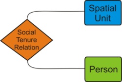
Figure 1 Social Tenure Domain Model (STDM).
STDM is an adaptation of the Land Administration Domain Model (LADM).
The LADM is an ISO standard, linked to initiatives by the Open GIS
Consortium (OGC) and Infrastructure for Spatial Information in the
European Community (INSPIRE). The LADM core is based on two core classes
Person and RegisterObject (e.g. a title or deed), which are related
through a third class RRR (Rights, Restrictions, and Responsibilities),
which can be expanded into a number of specialised sub-classes (Hespanha
et al 2008, Lemmen and van Oosterom 2006).
The STDM is proposed as a specialisation of the LADM as an ISO standard
(Lemmen 2010).
As per figure 1, the STDM has recast the Rights, Restrictions and
Responsibilities relationship as Social Tenure. The RegisterObject class
has been renamed SpatialUnit, and the Person class is unchanged. Lemmen
et al (2007) argue that it is possible to merge formal and informal
tenure systems in STDM. This is achieved by introducing lookup tables
and keywords to represent different kinds of SocialTenureRelations
(formal and customary relations, instead of rights, restrictions and
responsibilities) such as ownership, apartment rights, possessory
rights, Waqf (Islamic law), occupation interest, and other similar
rights and interests.
The simple form of the STDM design is a major strongpoint, as
simplicity should lead to a system that is easy to use. The three
primary classes in figure 1 are likely to prove to be suited to many
situations. However, as noted above, simple form may not capture the
complexity of a number of situations, especially if these are wicked
problem scenarios. The STDM is an adaptation of the LADM core, which was
developed for a very different set of circumstances (i.e. the European
Union) and grounded in a top down rather than systemic way of thinking
about problem situations.
Our main criticism is that setting the STDM as an ISO standard is
premature. It is a prescription yet to be supported by compelling
evidence derived from long and sustained usage. An international
standard should be based on empirical support in a number of different
types of situations over long periods of time. As the discussion above
indicates, there is empirical evidence to show when titling is
appropriate in a given situation and when not. In contrast, we have yet
to acquire sufficient, appropriate, long-standing and diverse empirical
evidence for any alternative LTIS to be promoted as an international
standard. The risk of setting it as an ISO standard may result in it
being specified in project documents without the critical scrutiny to
check if it suits the local circumstances. Suitability to circumstances
is nothing new as a critical success factor (CSF) in land tenure
information systems; it was listed as a CSF for a registration system by
Fortescue-Brickdale (1913) one hundred years ago.
3. TALKING TITLER DESIGN PHILOSOPHY
Figure 2 portrays different future states for an evolving LTIS.
Scenarios A, B and C represent some form of system with which designers
are familiar, such as an existing registration system, an occupation
permit system, taxation information system or combination of these
systems. The fourth one represents the very different system alluded to
above.
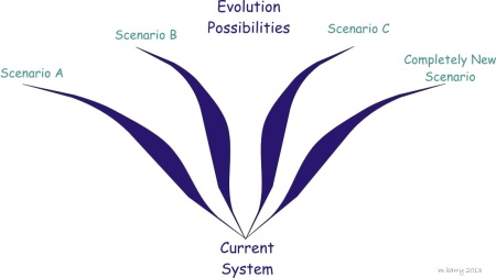
Figure 2 Evolution Scenarios
To address these different scenarios, there are two approaches to
system design. The first approach addresses the completely new scenario,
and has parallels with grounded theory research methodology in the
social sciences. The design should be grounded in the data, and in an
uncertain situation the design should emerge from the data rather than a
top-down prescription. The initial design focus should on the data alone
(Media class in figure 4).
The second approach addresses scenarios A, B and C and it allows a
LTIS to evolve based on four core classes, Media, Person, Land Object
and Reference Item (see figure 5). (The Person and Land Object classes
have equivalents in the STDM and LADM). Evolution tends to occur based
on one or more of the Person, Land Object and Reference Instrument
classes. The Reference Item class reflects what happens in practice most
of the time. In our studies, local record systems tend to be based on
some form of reference document or documents, such as a title, a file
number, a rent card or occupation permit and some form of map with
unique identifiers to model land parcels, linear and point features and
3-d objects (e.g. building or shack numbers). Media may comprise
unstructured data items, such as video clips, photographs, sound
recordings, written notes and reports, and formal or iconic data items
such as title deeds, contracts, permits, wills, marriage contracts and
cadastral survey plans.
Our limited experience at the local level indicates that several
system starts ups and failures may occur in uncertain situations. Thus a
design may revert back to the starting point, i.e. the data in the Media
class, if the first design does not work. Experience has shown that in
certain situations, a “well designed” GIS may be ignored by people on
the ground, even if they participate in its development. Instead,
completely unstructured data, such as the noting of events and
relationships in a notebook (or sound recordings or a video) may be
appropriate at a particular time (Barry and Fourie 2002a).
4. INFORMATION SYSTEM DESIGN STRATEGIES
We can consider two forms of information system design and
development, top down and evolutionary.
A top down approach is ideal in stable situations where the problem
contexts are simple and well understood, and it fits in well with the
bureaucratic organisational culture typical of many land administration
institutions. Top down, detailed design is especially appropriate in the
design and implementation of information systems which support land
registration. Land registration’s primary purpose is to provide
procedural effect to real property law (Ziff 2006). It follows that
there may be severe legal and social repercussions if an information
system that supports legal procedure is ineffective, particularly if it
does not deliver what the law prescribes. At the national or
jurisdiction level, a host of other land administration functions draw
on land registry data, hence the need for broad top-down
inter-institutional LIS planning and design.
In evolutionary design, the planning philosophy is not to plan;
information systems evolve and a clear end goal is not known (Patel
2009, Miller 1985). It fits anarchic or democratic organisational
cultures, where creative thinking, risk taking and innovation are
encouraged. Innovative solutions may arise from this method, but the
risks are that incompatible systems and nodes of information systems
power may emerge in different locations and institutions. Ideally,
however, some form of coordination institution should oversee the
process to avoid vastly different, incompatible designs emerging which
cannot be integrated or at least harmonised with a jurisdiction based
LTIS at a later stage. Thus standards such as the LADM serve as a useful
reference point, even if the design emerges and evolves from the data.
However, this is outside the scope of this article. We now move on to a
discussion of the conceptual data model for evolutionary LTIS
development based on the Talking Titler model.
5. CONCEPTUAL EVOLUTIONARY MODEL
The evolutionary model involves continual prototyping and
development. Prototypes can take on a number of forms. Of relevance are
throwaway prototypes and evolutionary forms. The throwaway type is used
to explore and experiment with certain parts of the final system design
and it is then discarded. In the evolutionary form the software may
evolve from an initial form featuring a number of core features which
will be retained as it is gradually developed to a final form (Davis
1992, Budgen 2003). Both of these forms may be relevant to LTIS
evolution.
An evolutionary development approach starts with an initial
operational system which gradually evolves over time. The initial
operational system builds the core requirements that are
well-understood, and it progresses as modifications to requirements are
required and other requirements emerge. This approach works well when
users are unsure about what they want initially (i.e. uncertain user
needs), but they can formulate an idea about them when they see them
implemented in a working system (Boehm 1988). In evolutionary
development, the system changes on an on-going basis. Often there is no
notion of a final product, but rather the notion of current state of the
system (Patel 2009, Budgen 2003, Beynon-Davies et al 1999).
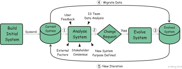
Figure 3 Evolutionary LTIS Development
As per figure 3, the evolutionary process commences with a simple,
flexible, initial system. The initial system is designed to address an
immediate problem situation, such as the post-conflict rebuilding
process following civil war, where the social and political environment
is likely to be unstable, uncertain and rapidly changing (Augustinus and
Barry 2006). The initial system implements basic requirements only,
while allowing a great deal of flexibility in how this is achieved. The
primary purpose is to collect data quickly, allowing different data
types to be collected within a loose structure (Muhsen 2008). The more
uncertainty in the situation the information system is meant to serve,
the more flexible it should be.
In our work to date, the initial system comprises two main
components, an initial three class data model and the initial software
prototype. The data model has three general abstract classes, namely
Person, Land Object and Media as per figure 4. Each of these can be
related to the other classes and to itself in many-to-many
relationships.
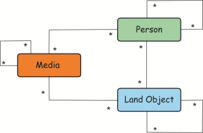
Figure 4 Talking Titler Three-Class Conceptual Model
The Person class includes anyone (e.g. individual person, legal
person, money lender, social group) who might hold an interest in land
and/or be involved in administering it (e.g. a land surveyor, system
operator). Social structures and lineage groups are represented via
recursive relationships (a relationship between a person and another
person) which enable modelling parent–child relationships, inheritance,
and other interpersonal relationships.
The Land Object class may represent things such as parcels, volumes
of space, dwellings, trees, hunters’ trap lines, religious artefacts,
water bodies, mineral deposits, and/or any spatial object of economic or
cultural value (Muhsen and Barry 2008). Recursive relationships on Land
Objects allow situations within and between objects to be modelled. For
example, a dwelling is located on a parcel and a tree may be located on
the same parcel. Entitlement to the land may be held by one person, the
dwelling by another and the tree by yet another person. The entitlements
to use the dwelling and parts of the fruits of the tree may vest in a
number of other persons, which in turn may stem from a number of
personal relationships.
The Media class contains a mix of records that might represent
different items of evidence relating to the existence of persons or land
objects and the relationships between them such as interests and
obligations between people and between people and the land. The data may
be structured, semi-structured and unstructured. Media items might
include, for example, titles, deeds, and survey plans describing parcel
lots, marriage certificates, and rent cards, and multi-media recordings
of dances, stories, ceremonies, video recordings of customary rules
relating to chieftaincy succession and land allocation rules, recordings
of symbolic land transactions, meetings, dispute resolution proceedings,
and personal testimonies.
The recursive relationship relates a media item to another media
item. For example, in a conventional cadastral survey records system
when a new survey diagram supersedes a cancelled survey diagram, it is
necessary to keep both media items in the system and relate them to
retain the chain of title. If we fail to relate them, we may lose the
chain, and possibly vital evidence in the event of a boundary conflict.
Or, audio recordings may be used in conjunction with photographs (a
slide show) to capture an event, and all of these media items should be
related to one another or to the event.
6. SYSTEM EVOLUTION
The system may evolve in a number of different ways, and we have
experimented with schema evolution to manage this to address a set of
known outcomes such as scenarios A, B and C in figure 2. Schema
evolution in this experimental work implies adding more general classes
to the three main classes in Figures 4 and 5, by decomposing the
generalized classes into more specialized ones, and adding additional
attributes to these classes (Molero et al 2010).
Using the example of a post conflict situation, it may be necessary
to change the schema in a vastly changing environment to address more
specialised needs. For example, we may introduce a fourth general class,
Reference Instrument as shown in figure 5. We may start off using a
variety of reference instruments, such as certificate of occupation,
taxation certificate, title deed and so forth, in this class and
differentiate between them by identifier type.
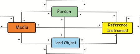
Figure 5 Talking Titler Four-Class Conceptual Model
We might then choose to separate these into sub-classes of the
reference instrument class at a later stage once we are reasonably
certain that the design meets the situation’s requirements. As figure 6
shows, we could specialise classes in the reference class, such as a
deed and a valuation record, and keep all other types of reference
instruments in the parent reference class until we’re reasonably certain
that we will keep them, whereupon we will separate them into specialised
classes as the system evolves.
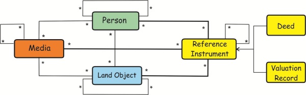
Figure 6 Talking Titler Specializations of Reference Instrument Class.
In an ideal design, we should be able to generalise the system to
revert back to an earlier state. The system may evolve from System0
through several stages to say System7 (Figure 3). It may then be found
to be completely unsuitable and we may have to start all over again at a
new System0 (e.g. if there is a change in government which has a
different approach to land management and administration) or revert back
to an earlier system number. Ideally, we should be able to revert back
to any particular evolutionary stage.
7. DATA MIGRATION
Data migration is the last step of a cycle in the methodology
outlined in figure 3. It aims to move the data from the old design to
the evolved one. In principle, the migration process involves three main
tasks, namely: data extraction from the old model, transformation of
data to suit the format and requirements needed for the new model, and
data loading in which data is imported to the new model. Lastly, data
verification should be performed at the end of the migration to check
for errors (Kimball and Caserta 2004)
We now describe the concept of self-adapting software using a XML
database. Using a XML database has advantages in an evolutionary
approach as in general a XML database is more flexible than a relational
database. On top of this, it should be easier to extract data from the
system at any stage and allow it to be used by a new, evolved, system or
by other systems.
8. EVOLUTION SCENARIOS AND THE SELF-ADAPTIVE APPROACH
Changes in a system can be frequent, unforeseen, and caused by a
diversity of factors (Buckley et al. 2005). Continual prototyping and
development associated with the evolutionary process implies repeated
refactoring of the system, which requires skilled IT personnel and the
associated costs. This places a question mark over the feasibility of an
evolutionary model, given that budgets and IT skills capacity are often
limited in uncertain land tenure situations (Barry and Fourie 2002b).
In order to reduce the negative impacts of the evolutionary
development approach, self-adaptive systems may alleviate some of these
problems. A self-adaptive system is a system which has the capacity to
modify itself at runtime in response to changes introduced by an
internal decision making process or by external factors such as user
input (Andersson et al. 2009, Salehie and Tahvildari 2009).
Drawing on Cheng et al. (2009), there are four major factors to be
addressed in developing a self-adaptive system:
- Modelling Dimensions. This concerns the definition of models
that represent: (1) objectives, (2) changes occurring at runtime,
(3) how the system should react to those changes, and (4) dealing
with the effects of changes.
- Requirements. This concerns the specification of: (1) what the
system should do, (2) what adaptations are possible, (3) constraints
on these adaptations, and (4) how to deal with the uncertainty of
not knowing what future requirements could be.
- Engineering. This concerns the implementation and control of the
feedback loop that underlies the dynamic behaviour of the system
which enables internal decision making and self-adaptation.
- Assurances. This concerns the assessment, verification and
validation of the changes taking place on the system at runtime.
To improve feasibility prospects, a self-adaptive LTIS development
approach should address these factors in a manner that the complexity
and costs associated with self-adaption do not outweigh the benefits of
flexibility. Special emphasis should be made on quality management as
changes occur, especially data and relationship integrity, because LTIS
are especially sensitive to users’ trust. Incorrect information in land
tenure recording processes can have major social and legal consequences.
Addressing the above challenge is not trivial and there is no general or
simple methodology for developing a self-adaptive system.
Ideally a self-adaptive system should be able to handle whole
feedback loop iterations in an evolutionary cycle on its own (see Figure
2). However, to achieve the ideal where no human intervention is needed
is perhaps utopian, but a self-adaptive approach may result in a
significant reduction in human intervention.
To date we have experimented with self-adaptation at the database
level, which we describe in the next section. Other components that have
to be adapted as a system evolves in the multi-tier software
architecture used in our exploratory self-adapting system are the user
interface and the middleware that handles the interaction between the
interface and the database.
9. CASE STUDY: EVOLUTION OF XML-BASED LAND RECORDS
XML (W3C 2008) is a widely used markup language and data format,
especially for data exchange between applications even when these
applications do not store data under the same structure. Among its
benefits are flexibility and ease of use as users may specify their own
data structure and extend the structure it to meet their specific needs
(Harold and Means 2002).
We developed and tested a self-adaptive design using the eXist-db
open source XML database based on a case of an informal settlement
upgrade where people were moved from shacks in an informal settlement to
formal houses in a new development (Barry 2006). There are four phases
or evolutionary steps in the experimental model.
- In Phase 1 social and demographic information is captured as
multimedia and text documents (MEDIA class) and related to the
people living in the informal settlement (PEOPLE class) and the
shack that they occupy (LAND OBJECT class) (see figure 4).
- In Phase 2 the local authority decides to relocate the people in
each shack to a formal house in a different location. This change is
represented as a new relation between two land objects, the shack
and the house (figure 4).
- In Phase 3, official recognition of rights over the new land is
addressed by issuing an occupation permit to the families,
introducing a new INSTRUMENT class and its relations to the existing
classes (figure 5).
- In Phase 4, formalization of rights over the new land is
completed by issuing a title; the title is linked to the household’s
occupation permit in case of fraud or errors in the process. The
people who were not allocated a house remain in the informal
settlement and the occupation permit provides official recognition
of an occupation entitlement. Drawing on Figure 6, the INSTRUMENT
class is specialised into an OCCUPATION PERMIT class and a TITLE
CLASS.
Phases 2 to 4 impose changes to the database structure. The
introduction of these changes is possible because of the database schema
evolution process built into the database.
As per Cheng at al’s (2009) factors, the case study can be roughly
summarized as follows (Molero et al. 2010):
- Modelling Dimensions:
- The main objective is to allow for specialization of the
land administration model over time.
- The database should be flexible enough to allow for database
schema changes while preserving existing data and consistency.
- Requirements:
- The initial land administration model should allow the
changes in Phases 1 -4.
- Possible changes to the initial model include: adding new
classes, adding new attributes to existing classes, defining
relations between classes, modifying existing classes, and
specializing classes through inheritance, among others.
- Changes in the initial model should be translated into
database changes.
- Existing instances of the data should be updated if their
structure has been changed.
- Automation of the adaptation process model change - database
schema update -instances affected migration should be done with
minimal intervention by the database administrator.
- Engineering:
- The initial model is represented in UML, which it is then
stored as XMI (XML Metadata Interchange; a XML for model
representation and exchange).
- The initial model is translated into a XML Schema (W3C
2004).
- Data instances are stored following the current XML Schema.
- Changes in requirements are introduced in the form of
changes in the UML model.
- The adaptation process is triggered by user input on the UML
model.
- The series of changes provided are in turn converted into
XML Schema changes.
- No XML instances updates are performed unless they are
solicited by the user in which case the instances are
transformed to conform to the new schema before the instances
reach the user.
- The feedback loop is controlled in such a way that
intervention from the database administrator is expected only if
strictly necessary.
- All changes occurring at runtime are documented within the
database for validation purposes.
- Assurances:
- Validation of the schema evolution mechanisms taking place
is currently performed verifying the correctness of the data
instances after the adaptation occurs; i.e. old instances still
exists, old instances meet the new database schema, old
instances are still correct, and new instances are stored using
the new database schema.
- For quality control, unit tests are used for internal
validation. A unit test is an automated task within the system
that performs an operation for a given input and expects a given
result. If a failure is detected the data instance is then
flagged for manual revision
We could not get the process to work entirely through all four phases
as there were some types of changes that required an administrator’s
intervention (Molero et al 2010). However, these can be addressed with
further work. Notwithstanding, the design and testing indicates that the
concept does hold promise and that forms of self-adaptive LTIS are
feasible with further work.
10. CONCLUDING REMARKS
In conclusion, flexible and evolutionary LTIS systems are one
strategic option where conventional land registration systems, with
their rigid rules and procedures, are not suited to the local
circumstances. We have described a conceptual approach to the
evolutionary LTIS development problem and one area of design,
development and testing that our research group has done in this area.
These are concepts that may evolve into practical solutions in the
future, but significantly more work needs to be done in this area.
In the mean time, at the practical level, flexible evolutionary
methods should be developed and applied in computer assisted
applications on the ground that accommodate both analogue and digital
data. In our observation, the reality is that many digital land
information systems are designed and implemented using a project based
approach, with little attention to the systems required for the system
to be a going concern. Thus system planning should accommodate the
scenario where a computerised system may collapse completely - for a
variety of reasons (e.g. key staff members leave, computer hardware
breaks down or is destroyed, failure of management to maintain
administrative procedures).
A XML based approach to data storage and sharing, along with well
designed methods of storing data outside of the IT system but in
parallel with it, e.g. using hard copy plans and documents to perform
administration and filing systems that accommodate DVD’s and similar
devices to store multimedia data, may mitigate some of these risks and
facilitate the revival of the system.
A problem is that flexible, evolutionary forms of LTIS tend to lack
appeal to the user community. As outlined elsewhere (Barry 2009b), the
simpler the LTIS, the more likely it will be easy to use and the more
likely the system will actually be used. Conversely the simpler the
system, the less likely it will provide an adequate model of complex
tenure situations or address wicked problem situations. In a worst case
scenario, a simplistic system may exacerbate an already troubled
situation. The more flexible the system, the more relationships and the
greater the level of complexity can be modelled, and the more likely it
will be mirror the situation on the ground. But, the more flexible and
complex the LTIS, the less likely it will be easy to use, and the less
likely it will actually be used. It is a conundrum that has kept
information system designers occupied for a long time, and it should
keep LTIS designers and researchers similarly occupied.
ACKNOWLEDMENT
This study was supported by the John Holmlund Chair in Land Tenure
and Cadastral Systems and the Canadian National Science and Engineering
Research Council Talking Titler project.
REFERENCES
Andersson, J., de Lemos, R., Malek, S., and Weyns, D., 2009.
Reflecting on self-adaptive software systems. In Software Engineering
for Adaptive and Self-Managing Systems, 2009. SEAMS '09. ICSE Workshop
on. Software Engineering for Adaptive and Self-Managing Systems, 2009.
SEAMS '09. ICSE Workshop on. pp. 38-47.
Augustinus and Deininger, 2005. Innovations in Land Tenure, Reform
and Administration in Africa. Available at
http://www.capri.cgiar.org/wp/..\pdf\brief_land-06.pdf.
Augustinus, C., and Barry, M., 2006. Land Management Strategy
Formulation in Post Conflict Societies. Survey Review, 38(302), 668-681.
Barodien G and Barry M 2004. Palm Computers for Spatially Referenced
Social Surveys in Upgrading Informal Settlements. New Zealand Surveyor
294(June 2004), 3-9.
Barry M 1995. Conceptual Design of a Communal Land Registration
System for South Africa. South African Journal of Surveying and Mapping,
December 1995, 23(3), No 139, 153 - 162.
Barry M, Roux L, Barodien G and Bishop I 2002. Video-evidencing and
Palmtop Computer Technology to support formalising Land Rights.
Development Southern Africa 19(2), 261-272.
Barry M and Fourie C 2002a. Wicked Problems, Soft Systems and
Cadastral Systems in Periods of Uncertainty: South African Experience.
Survey Review. 36(285), 483-496.
Barry M and Fourie C 2002b. Analysing cadastral systems in uncertain
situations: a conceptual framework based on soft systems theory.
International Journal of Geographical Information Science, 16(1), 23–40.
Barry M and Khan K 2005. Developing Talking Titler Methods in
Creating Land Records. Research Report to Natural Resources Canada,
Surveyor General, Western Region.
Barry M 2006. Formalising Informal Land Rights: the case of Marconi
Beam and Joe Slovo Park. Habitat International. 30(2006), 628 – 644.
Barry M 2009a. Land Administration Strategy Formulation using GIS in
Post Conflict Hargeisa, Somaliland. Surveys and Land Information
Science. 69(1), March 2009, 39 – 52.
Barry M 2009b. Standards for Oral Tradition Evidence: Guidelines from
First Nations Land Claims in Canada. 7th FIG Regional Conference, Land
Governance and the Environment, Hanoi, Vietnam, 19 -21 October 2009.
Barry M 2009c. Innovative Response to Land Registration, Customary
Title and Land Conflict: Applying Talking Titler Methodology: Report No
4 February 2009. British Council, Security Justice and Growth Programme,
Nigeria.
Barry M, Hunter A, Muhsen A 2009. Scalable Land Tenure Record
Systems. Technika Chronika Tech. Chron. Sci. J. TCG, I, No 1-2.
Barry M, Molero R and Muhsen A-R. 2013. Talking Titler: Evolutionary
and Self-Adaptive Land Tenure Information System Development. South
African Journal of Geomatics, Vol. 2, No. 1, January 2013.
Beynon-Davies, P., D. Tudhope, and H. Mackay. 1999. Information
systems prototyping in practice. Journal of Information Technology 14,
(1): 107-20.
Buckingham Shum S. 1997. Representing Hard-to-Formalise,
Contextualised, Multidisciplinary, Organis¬ational Knowledge. AAAI
Spring Symposium on Artificial Intelligence in Knowledge Management
(Mar. 24-26, 1997), Stanford University, Palo Alto, CA, AAAI Press.
Boehm, B. W. 1988. A spiral model of software development and
enhancement. Computer 21, (5): 61-72.
Buckley, J., Mens, T., Zenger, M., Rachid, A., and Kniesel, G., 2005.
Towards a taxonomy of software change. Journal of Software Maintenance
and Evolution: Research and Practice, 17(5), 309–332.
Budgen, D. 2003. Software design. 2nd Edition ed. Harlow, England:
Addison Wesley.
Cheng, B., et al., 2009. Software engineering for self-adaptive
systems: A research roadmap. Software Engineering for Self-Adaptive
Systems, 1–26.
Cousins, B, Cousins, T., Hornby, D., Kingwill, R., Royston, L., and
Smit, W., 2005. Will formalising property rights reduce poverty in South
Africa’s “Second Economy?” Questioning the mythologies of Hernando de
Soto. Policy Brief. Debating land reform, natural resources and poverty.
N° 18, (October 2005), 1-6, PLAAS, Programme for Land and Agrarian
Studies.
Danso E and Barry M 2012, Land Tenure Administration in Peri-Urban
Accra: A Case Study of Bortianor. FIG Working Week, Rome, Italy, 6-10
May 2012, TS09A - Customary and Group Land Rights, 5739.
Davis, A. 1992. Operational prototyping: A new development approach.
Software, IEEE 9, (5): 70-8.
De Soto, H., 2000. The mystery of capital: why capitalism triumphs in
the west and fails everywhere else. New York: Basic Books.
Deininger, K. 2003: Land Policies for Growth and Poverty Reduction,
Washington DC, World Bank.
Deininger K and Feder G 2009. Land Registration, Governance and
Development. World Bank Research Observer, 24(2), 233 -266.
Edmead, N 2010. Open Title: a Low Cost Tool for Inventorying Property
Rights - Experiences from Ghana In Land Tenure and Land Management
Projects in developing Countries. FIG Congress -Facing the Challenges –
Building the Capacity Sydney, Australia,
Fortescue-Brickdale C 1913. Methods of Land Transfer. London, Stevens
& Sons.
Gilbert, A., 2002. On the Mystery of Capital and the Myths of
Hernando de Soto: What Difference Does Legal Title Make? International
Development Planning Review, 24 (1), 1-19.
Harold, E.R., and Means, W.S., 2002. XML in a Nutshell, O'Reilly &
Associates, Inc. Sebastopol, CA, USA.
Hespanha J,van Oosterom P, Zevenbergen J, and Dias G 2006. A modular
standard for the cadastral domain: Application to the Portuguese
Cadastre. Computers, Environment and Urban Systems, 30 (2006) 562–584.
ISO/FDIS 19152.
http://www.iso.org/iso/home/store/catalogue_tc/catalogue_detail.htm?csnumber=51206
Kimball, R., and J. Caserta. 2004. The data warehouse ETL toolkit:
Practical techniques for extracting, cleaning, conforming, and
delivering data. John Wiley & Sons, Inc.
Lemmen, C., and van Oosterom, P., 2006. Version 1.0 of the core
cadastral domain model. Paper presented at XXIII FIG Congress – shaping
the change, Munich, Germany.
Lemmen, C., Augustinus, C., van Oosterom, P., and van der Molen, P.,
2007. The Social Tenure Domain Model - Specifications of a First Draft
Model. Paper presented at the Strategic Integration of Surveying
Services, FIG Working Week, Hong Kong SAR, China.
Lemmen C 2010. The Social Tenure Domain Model A Pro-Poor Land Tool.
International Federation Of Surveyors (FIG), Global Land Tool Network
(GLTN), United Nations Human Settlements Programme (UN-Habitat)
Lemmen C, Uitermark H, Van Oosterom P, Zevenbergen J, Greenway I
2011. The Road to a Standard Land Administration Domain Model, and
Beyond. Proceedings FIG Working Week 2011. Marrakech, Morocco.
Mason S, Barry M, Crone S, Geffen N, Camroodien L 1998. Information
Management System for Affordable Housing Provision. South African
Journal of Surveying and Mapping, 24(3), 129-138.
Miller, J.M., 1985. Information Systems Planning - Principles and
Practice, South African Journal of Library Information Science, 53(4)
183-190.
Molero, R., Barry, M., and Hunter, A., 2010. Evolution of XML-based
land records database for uncertain land administration situations. In:
Proceedings of the Joint FIG Commission 3 and Commission 7 Workshop
2010, Sofia, Bulgaria, 15-17 November, 2010.
Muhsen A-R 2008. Developing Multimedia Land Record Systems. MSc
thesis, University of Calgary, UCGE Report 20283.
http://www.ucalgary.ca/engo_webdocs/MB/09.20283_AbdelMuhsen.pdf
Muhsen A-R and Barry M B 2008. Technical Challenges in Developing
Flexible Land Records Software. Surveys and Land Information Science.
68(3), 171-181.
Patel, N. 2009. Theory of Deferred Action: Informing the Design of
Information Systems for Complexity, Ch X in Yogesh K D, Lai B, Williams
M D, Schneberger S L and Wade M (Eds) Handbook of Research on
Contemporary Theoretical Models in Information Systems. Information
Science Reference, New York.
Payne G 2002. Introduction in Geoffrey Payne (Ed.) (2002) Land,
Rights and Innovation: Improving Tenure Security for the Urban Poor.
London: ITDG Publishing.
Payne G 2008. Owning up: what price home ownership? Housing Finance
International, 23(2), 12-18.
Payne G, Durand-Lasserve A, and Rakodi C 2009. The limits of land
titling and home ownership. Environment & Urbanization. Vol 21(2):
443–462
Platteau, J.P. 1996. The Evolutionary Theory of Land Rights as
Applied To sub-Saharan Africa: A Critical Assessment, Development and
Change, 27(1986), 29-86.
Pullar N, Mcdowell A, Solovov A, Manoku E And Rizzo M P 2012.
Solutions for Open Land Administration (Sola) Software - Customising
Open Source Software to Support Land Administration Services and
Responsible Land Governance, World Bank Conference on Land and Poverty,
April 23 – 26 Washington DC.
Rittel, H. J., and M. M. Webber (1984). Planning problems are wicked
problems, In N. Cross (Ed.), Developments in Design Methodology, Wiley,
pp. 135-144.
Rittel, H. W. J. & Webber, M. M. (1973). Dilemmas in a General Theory
of Planning. Policy Sciences, 4, 155-169.
Roddick, J.F., 1995. A survey of schema versioning issues for
database systems. Information and Software Technology, 37(7), 383-393.
Roux L and Barry M 2001. Using Video Imagery in Land Tenure
Information Systems: A Study of a Communal Property Association in the
village of Algeria, South Africa . Geomatica 55(1), 47-55.
Roux L and Barry M 2011. Land Transactions in Social Housing in the
Western Cape of South Africa: A Narrative of Kransdorp. Proceedings
AfricaGeo, Cape Town 31 May – 2 June 2011.
Salehie, M., and Tahvildari, L., 2009. Self-adaptive software:
Landscape and research challenges. ACM Transactions on Autonomous and
Adaptive Systems (TAAS), 4, 14:1–14:42.
Shipton P 2009. Mortgaging the Ancestors. Ideologies of Attachment in
Africa, Yale University Press, New Haven.
Sjaastad, E & Cousins, B, 2008 Formalisation of land rights in the
South: An overview. Land Use Policy, 26(1), 1-9.
W3C, 2004, XML Schema Part 0: Primer (Second edition), Retrieved
2010, October 10, from http://www.w3.org/TR/xmlschema-0/.
W3C, 2008, Extensible markup language (XML) 1.0 (Fifth edition),
Retrieved 2010, October 10, from http://www.w3.org/TR/REC-xml/
Ziff B 2006. Principles of Property Law, 4th Edition, Thomson -
Carswell Toronto.
This study was supported by the John Holmlund Chair in Land Tenure
and Cadastral Systems and the Canadian National Science and Engineering
Research Council Talking Titler project.
CONTACTS
Michael BARRY
E-mail: mbarry@ucalgary.ca
Web site: www.ucalgary.ca/MikeBarry
Richard MOLERO
E-mail: rmmolero@ucalgary.ca
Abdel-Rahman MUHSEN
E-mail:
abdel-rahman.muhsen@accenture.com
 |


