Article of the Month -
June 2008
|
What Makes the Swedish Cadastral System so
Special and Successful?
Mrs. Agneta ERICSSON, Sweden
 This article in .pdf-format (11
pages and 1,133 kB)
This article in .pdf-format (11
pages and 1,133 kB)
1) This paper has been prepared for
presentation at the FIG Working Week in Stockholm, Sweden 14-19 June
2008.
Key words: cadastral system, benchmarking, process leader,
legislation.
SUMMARY
The Swedish cadastral system is so special and successful because;
The cadastral survey;
- delivers real properties that are complete with different kind
of attribute, like roads, sewage etc.
- improves the division of land and ensures fragmentation of land
is avoided.
- assures the applicant has a sustainable investment for the
future.
- guarantees that land is managed in an efficient manner in
accordance with land policies.
- real property division goes hand in hand with the land use.
The process;
- The land surveyor is responsible for the whole process and often
carries out all activities himself. This makes the cadastral process
easy to understand for the interested party and it alleviates the
need to involve any legal experts or other consultants.
The databases;
- The information is updated, comprehensive and well used in the
society. This makes the market economy function.
The legislation;
- New, sharp, unique legislation has been introduced in the
cadastral field during the last 30 years and the cadastral surveyors
responsibility has extended.
Although we consider the Swedish cadastral system to be successful,
we also realise that there is a danger for its survival! When different
benchmarking projects are comparing different aspects, it is difficult
to highlight what the systems stand for and what kinds of products are
delivered. Can an alternative concept, like the Swedish, survive in
Europe although it is simple, smooth and successful?
1. INTRODUCTION
Benchmarking projects regarding different cadastral systems are
continuously carried out. Nice reports are produced and hopefully the
results can be used to encourage different organisations to improve
their performances! But what are we comparing and how can we use the
results from the different studies?
One very comprehensive study was carried out by the Nordic countries.
In this study the cadastral systems in the Nordic countries were
described in detail. The results from the study have been documented in
two reports “Dannelse og transaktioner vedrorende fast ejendom i de
nordiske lande” and “Ejendomsregistering i de nordiske lande”, 2006.
The findings were presented at a seminar in Copenhagen in August
2007. During this seminar I realised that, even though we often say that
the Nordic cadastral systems have a lot in common, the systems do not
deliver the same products! We often use the same terminology, but in
fact the words do not have the same meaning - not even in the Nordic
countries!
During this seminar I started to look upon the Swedish cadastral
system in a new way. I realised that there are a lot of important
aspects in the Swedish system that I never have appreciated; they were
simply a matter of course! The following describes different aspects
that make the Swedish cadastral system so special and successful.
2. BACKGROUND INFORMATION
The Swedish cadastral survey history goes back to the year 1628 when
the National Land Survey was established. The surveyors started the huge
task to measure all land and produce maps for the whole country. Large
land reforms took place with the first one starting in 1749. At this
time land was fragmented and the first land reform was quite radical;
the goal was to consolidate the fragmented lands of one farmer into one
parcel!
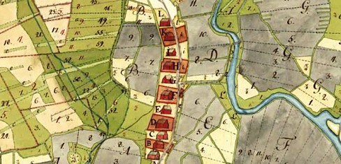
Land consolidation, Åsen, Ovansjö, County of Gävleborg, 1757
But time changed and strict land
reforms were replaced with total freedom. The late 1800´s was a period
without any land policy and with total freedom for the land owners to
split and divide land as they liked! This was the period when a lot of
Swedish people immigrated to USA. The authorities thought that free
division of the land could make people stay in Sweden. But this was not
the case. Instead the ownership of land became fragmented and the
management of land quite difficult. We still suffer from the results of
this era, especially in the county of Dalarna. People do not know what
they own; they can not find the real property boundaries and land can
not be managed in a proper way!
Comprehensive and expensive land consolidation projects in Dalarna, 2008
3. THE LEGISLATION
What did we do? New legislation was introduced in 1928 and a new era
with comprehensive land consolidation projects took place.
Current, modern, legislation was established in 1972 and included a
new land code and a real property formation act. At this time we also
started to convert our Land Register and Real Property Register into
digital form.
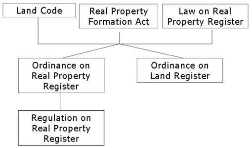
The new, modern land law and real property formation act was established
1972.
Today’s law structures are modern and logic. The laws together create
the play yard for the cadastral surveyor. Together with the Planning and
Building Act (1987) and Act of Environment (1999) the government has
created valuable instruments to implement its land policies. The Real
Property Formation Act includes subdivision, consolidation, mutations,
amalgamations, property determination and registration. The law is valid
in both urban and rural areas. The law is powerful and it authorises the
cadastral surveyor to decide about changes in the division of land, not
only on a voluntary basis. The law includes compulsory purchase.
Therefore, the cadastral survey process is frequently used in
infrastructure project instead of time consuming expropriation
processes.
The Real property formation act states that a prerequisite to make
any change in the property division is that the new division of land
must be sustainable on a long-term basis and it must be suitable for
its purpose. Otherwise it is not possible to make any change.
- E.g. you can create a new real property in an area with a detail
plan only if it is according to the plan.
- E.g., a new real property meant to be used as a permanent house
must have access to a road, water and sewage. Otherwise it is not
sustainable on a long-term basis and not suitable for its purpose.
- E.g., a person wishes to buy a piece of land in order to build a
summer cottage. Before the surveyor is allowed to fulfil the survey,
he must make sure that there are no restrictions on the land and
that there are no interests from the society. He/she must also make
sure that it will be possible to get building permission. Otherwise
the new real property is not sustainable on a long-term basis and
not suitable for its purpose.
- E.g. you can split a forest unit into new real properties only
if the new properties can be managed as professional forestry
properties.
- E.g. coastal areas have special restrictions and the general
public shall, as a general role, have access to the water.
Therefore, a subdivision for a summerhouse can only be done in such
areas as an exception.
Conclusion
The cadastral survey;
- delivers real properties that are complete with different kind
of attributes, like roads, sewage etc.
- improves the division of land and ensures fragmentation of land
is avoided.
- assures the applicant a sustainable investment for the future.
- guarantees that land is managed in an efficient manner in
accordance with land policies.
- real property division goes hand in hand with the land use.
The banks rely upon the cadastral system and can, without any vast
investigations, use the real property as a pledge.
3.1 Other useful legislation
Other useful legislations were introduced in 1973; the acts of
“Establishment of joint facilities”, “Formation of joint property
management associations” and “Utility easement law”.
Establishment of “joint facilities” and “joint property management
associations” are frequently used to solve the management and
administration of private roads in the country side. It is also used to
manage jointly owned parking areas, garages, playgrounds, pipelines etc.
E.g. A residential area with 35 separate units jointly owns garages and
a parking place.
To get a sustainable management of the area, a joint facility is
established, as well as a joint property management association. In this
way a juristic person is established which can make decisions about the
management of the construction. There is also a possibility for the
association secure bank loans.
 |
According to the “Utility Easement Law” a utility easement
can be created through a cadastral survey. A utility easement
gives the owner of an electric pipeline access to land for
constructing and managing the pipeline. The law is quite
powerful and it authorises the cadastral surveyor to decide not
only on a voluntary basis. The roles for economic compensation
are based upon the roles of the expropriation law.
The result of the cadastral survey is entered into the Real
Property register and cadastral index map. |
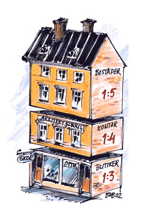 |
In 2004, Parliament decided to introduce the possibility to
create three-dimensional property units, by extending the Real
Property Formation Act. Joint facilities and joint property
management associations are often established to solve the
management of the common constructions in three dimensional
property units.
There are some important restrictions in the legislation
today; it is not possible to create three-dimensional property
units for dwelling units!
The new, non socialistic government is currently working for
a change in the three-dimensional paragraphs. Next year (2009)
we expect a change in the law that makes it possible to create
three-dimensional property units for dwelling units. |
3.2 Infrastructure projects
Due to the flexibility of the legislation, the same laws can be
applied in simple subdivision, comprehensive land consolidation projects
and infrastructure projects. Today, the cadastral surveyor gets more and
more involved in infrastructure project. Access to land for railway
projects can be fulfilled efficiently compared to an expropriation case
handled in court. To make the projects even more beneficial, it is
important to involve the cadastral survey as early as possible in the
project, since access to land can be quite time consuming. Also the
projects can be handled more efficiently, if the cadastral process runs
parallel with the infrastructure project as the project may use
information that has been produced from the cadastral survey process.
Conclusion; New, sharp, unique legislation has been introduced in the
cadastral field during the last 30 years and the cadastral surveyors
responsibility has extended. The cadastral survey organisation has often
taken different initiatives in order to achieve this.
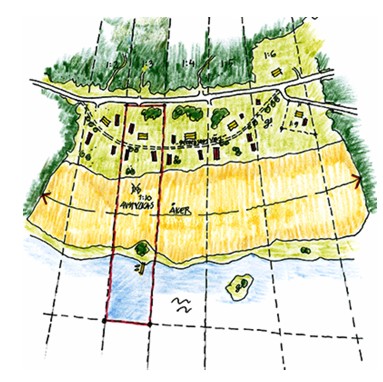
4. LAND POLICIES
As mentioned earlier the land policies, of course, have changed
through out the year. In 1970 all agriculture/farming land was protected
and could not be split and a residential real property could not be
larger than 1000 m². Today we have a new situation; the authorities
encourage people to live in the countryside. One example of this change
is the possibility to create so called “horse properties”. A “horse
property” can comprise much more than 1000 m² and include agriculture
land.
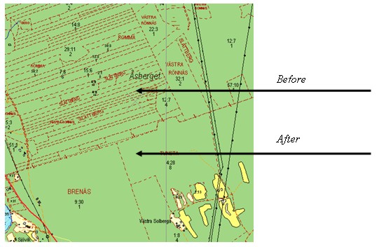
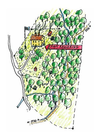
 |
E.g. Before the cadastral survey; One
large real property consisting of agricultural and forest land.
After the cadastral survey; Two
separate units. One unit consists of forest land. The other real
property becomes a residential real property with some
agricultural land. The family living on this unit combines their
ordinary jobs with raising sheep. |
 |
E.g. Before the cadastral survey; one
residential unit consists of 1000 m².
After the cadastral survey; one unit
consists of 3000 m². 2000 m² forest land has been merged into
the residential real property.
The forest area could not be managed by the
forestry company in a professional manner and therefore it was
possible to merge the land into the residential real property. |
Conclusion; Land policies have changed according to the
demands of society. The productive forest areas are now protected at the
same time as the people can get better conditions to remain in the
country side.
5. THE CADASTRAL SURVEY PROCESS
The cadastral survey can start when an application is sent to the
cadastral survey office. The cadastral case may involve anything from a
few concerned parties to several hundreds! The process consists of
following components;
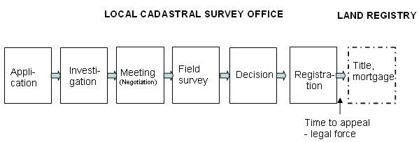
The land surveyor is responsible for the whole process and often
carries out all activities himself.
5.1 The cadastral surveyor as a process leader
The Swedish cadastral surveyor has a unique role. The cadastral
surveyor is authorised to make legal, economic as well as technical
decisions. The decisions made by the surveyor are to be regarded as a
first instance law decision. Therefore the land surveyor is employed by
the state or a municipality.
 |
The surveyor is obliged to make their own investigations.
During meetings, held with all concerned parties (the
applicants, neighbours etc.), the surveyor should encourage all
parties to be involved in the process, aiming at finding the
most beneficial solution for all (meetings are not compulsory in
all cases). The surveyor must, of course, follow the intention
of the laws, the land policies and regulations and he/she must
consult with the municipality, the county administration board
and different sector agencies like the Road Agency etc. |
When all concerned parties have been heard and if the investigation
shows that it is possible to implement the survey, the surveyor may
decide not only about the new division of land, but also about
easements, economic matters and new boundaries etc. He is also
responsible to secure the interests of creditors in case mortgages. He
can even decide that a new sub division shall be free from mortgages (he
must, of course, consider the banks interests).
The surveyor must not favour anyone; the decision must be fair. The
decision must consider the need of the society as well as concerned
parties. Therefore, the surveyor must be totally independent.
From the day when a decision is taken, any concerned party may
complain to court within 4 weeks. If no one complains, the decisions are
valid and the case is entered into the Real Property register. All
decisions and maps are documented in a legal act and the applicant can
get his/her own copy. The original document is filed at the county
survey office. Nowadays all cadastral acts are in digital format and are
therefore available via the Internet.
If the investigation shows that it is not possible to carry out the
real property formation e.g. due to a plan or a regulation, the
cadastral surveyor may decide to refuse the application. The applicant
may appeal this decision through courts.
Conclusion; one organisation and one person is responsible for
the whole cadastral process, including the registration into the Real
Property register. This makes the cadastral process easy to understand
for the interested party and alleviates the need to involve any legal
experts or other consultants.
5.2 A cadastral survey instead of expropriation in court
The cadastral survey is normally an efficient process to get access
to land for different purposes. Compared to cases handled in court, the
cadastral survey is more rapid and cost effective. In the cadastral
survey process, the land surveyor plays a much more active role than the
judge in the court. The land surveyor’s role is to collect all
information that is of importance for the current and future use of the
proposed property. This compares with the process conducted by the court
where investigations are conducted individually and the court only makes
a decision based upon the information placed before it.
Conclusion; The land survey process is efficient regarding
delivery time as well as cost!
6. THE REAL PROPERTY AND LAND REGISTER
In 1976 the Real Property and Land Register in the county of Uppsala
were integrated and converted and into digital format. Twenty years
later all remaining registers in Sweden were converted. The Cadastral
Index Map is also in digital form combined with topographic information.
The system has been developed through out the year and today it is very
comprehensive. The use of the system is extensive; more than 500 000
transactions are created per day!
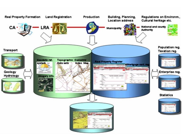
The information in the databases is continuously updated. Different
organizations are involved and information is exchanged between the
different organizations, like the taxation and population registers. In
this way we can support the society with updated information about real
property boundaries, owners (title), mortgages, addresses and taxation
values of the real property etc.
Different users like banks, real property market companies and
brokers can make business decisions efficiently. The banks do not need
to make their own investigation, they rely upon the information in the
registers which means that the land owner can get his mortgage and the
real estate company can make quick business!
The information is used by physical planners at local and regional
level and the data is used in different GIS applications. Today’s GPS
and navigation system is used frequently by professionals, such as taxi
drivers and transportation companies.
Conclusion; The information is up to date, comprehensive, well used
in the society and contributes to a well functioning market economy.
7. THE FUTURE
The Land Registry was merged into the Lantmateriet the 1 of June
2008! This is a great opportunity for the organisation to improve its
administration, processes, and develop common web applications etc.
Hopefully this will make life simpler for the customers, the general
public and our selves!
 |
The change in the climate is a
threat for all of us, but we believe the cadastral surveyor can
contribute in this area in different ways such as new
residential properties should not be created in potential flood
areas and wind power stations can be owned by a joint facility
and managed by a joint property management association etc. |
Although we consider the Swedish cadastral system to be successful,
we also realise that there is a danger for its survival! When different
benchmarking projects compare different aspects, it is difficult to
highlight what the systems stand for and what kinds of products are
delivered. Can an alternative concept survive in Europe although it is
simple, smooth and successful?
BIOGRAPHICAL NOTES
Mrs. Agneta Ericsson, born in 1950. Graduated in 1973 as M.Sc.
in Land Surveying, Royal Institute of Technology, Stockholm, Sweden.
Chief County Surveyor in Dalarna 1999-2007 and now Marketing Director at
Lantmateriet.
CONTACTS
Marketing Director Agneta Ericsson
Lantmäteriet
Lantmäterigatan 2
Gävle
SWEDEN
Tel. +46 26 633395
E-mail: agneta.ericsson@lm.se
Web site: www.lantmateriet.se
 |


