Article of the Month - December 2024
|
Improving Cadastral Accuracy for Disaster
Management: The Role of Segment Anything Model (SAM) in Digitizing
Historical Cadastral Maps
Sanjeevan Shrestha, Tina Baidar and Shangharsha
Thapa, Nepal
 |
 |
 |
| Sanjeevan SHRESTHA
|
Tina BAIDAR |
Shangharsha THAPA
|
This article in .pdf-format
(12 pages)
This paper was presented at the FIG Regional Conference 2024 in
Kathmandu, Nepal, 14-16 November 2024
SUMMARY
Up-to-date cadastral maps with detailed land ownership, boundaries,
and values, are crucial in disaster-prone regions like Nepal, where
accurate land data significantly impact disaster risk management for
efficient resource allocation, response planning, and so on. Given the
challenges associated with updating cadastral mapping, there is a
pressing need to digitize existing maps to establish an up-to-date
cadastral database. The digitization of old cadastral maps faces
challenges like inconsistent skill levels, human errors, and data
quality issues, making the process time-consuming and prone to
inaccuracies. Hence, automating the process is essential to create an
accurate and up-to-date cadastral database.
This study explores the application of the Segment Anything Model
(SAM) for automating the digitization of historical cadastral maps,
specifically focussing on land parcel boundary extraction, specifically
in the context of Nepal. Using a diverse dataset of scanned cadastral
maps, the study evaluates SAM’s zero-shot segmentation performance under
different prompting conditions, including bounding box, multi-point
prompts, and their combinations. Key factors such as parcel size, shape,
eccentricity, clarity of boundaries, and noise levels of the cadastral
map were analyzed. SAM demonstrated promising results, particularly when
employing combined prompts, but challenges arose in handling noisy data
near parcel boundaries and complex configurations within the parcel.
Moreover, false positives between segmented parcels continue to be
significant challenges, and increasing the scanning resolution also did
not noticeably improve segmentation accuracy.
The study concludes that SAM provides promising solutions for
enhancing cadastral digitization in Nepal. The challenges faced
highlight the need for integrating Geographic Information Systems (GIS)
with SAM, along with human oversight, to ensure the creation of accurate
and complete cadastral databases. Future research should focus on
fine-tuning SAM for one-shot learning or using SAM-2 model and
integrating it with diverse remote sensing data to further improve
segmentation accuracy and resilience in land administration systems.
1. INTRODUCTION
Nepal is highly vulnerable to various natural disasters, including
earthquakes, floods, landslides, and more recently, glacial lake
outburst floods (GLOFs). These disasters not only destroy lives and
properties but also adversely affect land administration by erasing
physical land boundaries and destroying land records (Lukman Syahid,
2011). In the event of a natural disaster, land tenure will only remain
secure if adequate land administration records exist or if landowners
possess legal documentation proving their rights to the land (Mitchell,
2009). The adverse effects of disasters can be minimized by
linking efficient land administration with disaster risk management.
Cadastral maps are foundational to land administration systems as they
provide detailed records of land parcels, ownership, boundaries, and
legal rights. These maps are essential for managing land-related
activities, including land registration, property taxation, and land use
planning. Up-to-date cadastral information is essential for disaster
risk management as it facilitates efficient resource allocation,
improves response planning, ensures accurate damage assessment, and
provides legal and administrative clarity (Lukman Syahid, 2011). It also
enables informed decision-making and improves environmental and risk
management strategies.
In the context of cadastral records of Nepal, the initial cadastral
survey, completed in 1995 A.D., provided analog cadastral maps for all
of Nepal but excluded densely populated areas such as village blocks and
public lands (Sapkota, 2012). As demands grew for accurate and easily
accessible land records, the Department of Land Information and Archive
(DoLIA) was established in 2000 A.D. to implement a Land Information
System (LIS) aimed at efficient land management. DoLIA began archiving
cadastral records and developing software systems for acquiring spatial
data from hard copies of cadastral sheets through digitization and their
attribute data as well (Sapkota, 2012). Despite these advancements,
significant challenges persist in the scanning and digitization of old
maps, including susceptibility to human errors, variability in
interpretation and digitization skills among personnel, and
inconsistencies in data quality. The digitization process remains
time-consuming and error-prone due to differing skill levels and
interpretations among individuals working on different map sections,
resulting in edge problems and data inconsistencies. Additionally, not
all personnel are proficient in digital technology, further complicating
the digitization efforts. Given the challenges associated with
digitizing cadastral records, there is a pressing need to automate the
process to establish an up-to-date cadastral database.
Several studies have been conducted since a long time on developing
automatic map interpretation systems and methods for the automatic
extraction of cadastral records, aiming to streamline and improve the
efficiency of cadastral map digitization and analysis. One of the
earliest studies used a baseline automatic cadastral map interpretation
method that employed processes including noise removal and
skeletonization of scanned maps, vectorization, parcel detection, and
interpretation (Janssen, Duin, & Vossepoel, 2002). Among the
recent studies, a study used a segmentation method that combined four
steps of image processing algorithms to extract land regions
automatically from historical cadastral maps and demonstrated that the
method extracted land boundaries with an average error of 0.62% with a
standard deviation of ± 0.61% (Kim, Lee, Lee, & Seo, 2014). The
results imply that while the average error is low, there are some
fluctuations in accuracy across different maps. The study also
acknowledges limitations in the approach, particularly when dealing with
maps that lack clear delineations or contain ambiguities. Another study
overviewed the use of deep learning techniques including convolutional
neural networks (CNN) and semantic segmentation methods, to automate the
digitization of historical cadastral maps (Ignjatić, Nikolić, Rikalović,
& Ćulibrk, 2018). The study addressed the limitations of the deep
learning algorithms that they require large, high-quality training
datasets and the models’ struggle with generalizing across different map
types. Moreover, accuracy concerns persist, particularly with faded or
complex map features, necessitating ongoing human oversight to correct
errors. Furthermore, another study assessed the application of
Object-Based Image Analysis (OBIA) procedures for the semi-automatic
digitalization of heritage maps including historical cadaster maps which
demonstrated OBIA techniuqe is viable approach to digitalization over
classical pixel based classification methods (Gobbi et al., 2019). The
limitations observed in previous studies are either lengthy procedures
involved in the case of pixel-based and object-based classifications and
complex (combination of) image processing algorithms or the
unavailability of large training datasets for deep neural networks such
as CNN to perform efficiently.
Segment Anything Model (SAM), recently released by Meta AI Research,
is a foundational model in the field of artificial intelligence. SAM has
been trained on a massive dataset, consisting of 11 million images and
1.1 billion masks, and it demonstrates impressive zero-shot performance
across a wide range of segmentation tasks (Kirillov et al., 2023).
Foundation models like SAM, which have made significant strides in both
natural language processing (NLP) and more recently in computer vision,
are capable of zero-shot learning. This means they can adapt to new
datasets and perform unfamiliar tasks using 'prompting' techniques, even
with little or no prior training. This capability has the potential to
reduce human efforts during the digitization and annotation process and
presents an opportunity to alleviate time-intensive tasks. A recent
study demonstrated promising adaptability to segmentation of various
remote sensing data (satellite, airborne, and UAV) and its
analysis and recommended further research models to improve the model’s
performance by integrating it with additional fine-tuning techniques and
other network architectures (Osco et al., 2023).
This study explores the potential of the Segment Anything Model (SAM)
for the automatic digitalization of historical cadastral maps, with a
specific focus on land parcel boundary extraction. The primary objective
is to assess the feasibility and effectiveness of SAM in automating the
segmentation of land parcels from scanned cadastral maps into GIS
databases. The model's robustness and adaptability were evaluated under
varying scenarios and complexities of cadastral parcels in the context
of Nepal. A Zero-shot segmentation technique, based on SAM, was employed
throughout the study to examine its performance across diverse
conditions.
2. MATERIALS AND METHODS
The study has investigated SAM’s segmentation capacity with different
scanned cadastral maps under different prompting conditions. Figure 1
shows the schematic representation of the overall workflow of the study.
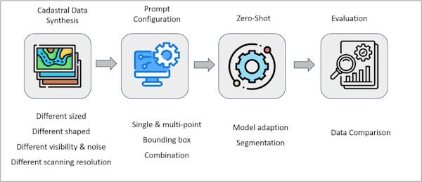
Figure 1: Schematic representation of a step-wise process for
evaluating the efficacy of SAM
2.1 Cadastral Data Synthesis
The dataset for this study comprises a diverse array of scanned
cadastral images, providing a broad foundation for evaluating the
Segment Anything Model (SAM) in terms of robustness and adaptability
across a wide range of conditions (Table 1). The georeferenced analog
cadastral maps were systematically categorized into five key attributes:
size, shape, visual clarity, noise condition, and scanning resolution,
allowing for a detailed exploration of SAM’s capabilities. Regarding
size, the dataset included images of uniform, large, and small
dimensions, facilitating the assessment of SAM’s performance across
varying parcel sizes. For shape, the dataset covered both regular
parcels and those with significant eccentricity, enabling the model’s
adaptability to irregular geometries to be tested. Visual clarity was
addressed by comparing parcels with clear and blurred boundaries, which
provided insight into SAM’s ability to handle imperfect or degraded
imagery. Noise conditions were evaluated by including both noisy and
noise-free images, simulating issues like scanning defects. All images
were initially scanned at a resolution of 300 DPI to standardize the
evaluation. To further explore the effect of resolution, the same
cadastral maps were scanned at 300, 400, 500, 600, and 800 DPI, allowing
an additional layer of analysis on SAM's performance in response to
varying image quality and detail. This multi-dimensional dataset serves
as a rigorous test bed for assessing SAM’s versatility and effectiveness
in automating land parcel boundary segmentation under diverse
conditions.
Table 1: Diverse cadastral datasets and prompting conditions
| S.N |
Condition |
Scenario |
Scanning
Resolution |
Target |
Box |
Point |
Combination |
| 1 |
Size |
Equal size |
300 |
Parcel |
Yes |
Yes |
Yes |
| 2 |
Big size |
300 |
Parcel |
Yes |
Yes |
Yes |
| 3 |
Small size |
300 |
Parcel |
Yes |
Yes |
Yes |
| 4 |
Shape |
Regular |
300 |
Parcel |
Yes |
Yes |
Yes |
| 5 |
Large
eccentricity |
300 |
Parcel |
Yes |
Yes |
Yes |
| 6 |
Visual
clarity |
Clear |
300 |
Parcel |
Yes |
Yes |
Yes |
| 7 |
Blur |
300 |
Parcel |
Yes |
Yes |
Yes |
| 8 |
Noise
Condition |
Noise-free |
300 |
Parcel |
Yes |
Yes |
Yes |
| 9 |
Noisy |
300 |
Parcel |
Yes |
Yes |
Yes |
| 10 |
Scanning
resolution |
300 |
Parcel |
No |
No |
Yes |
| 11 |
400 |
Parcel |
No |
No |
Yes |
| 12 |
500 |
Parcel |
No |
No |
Yes |
| 13 |
600 |
Parcel |
No |
No |
Yes |
| 14 |
800 |
Parcel |
No |
No |
Yes |
2.2 Prompt Configuration
The study particularly investigated SAM’s segmentation capacity in
the context of automatic extraction of parcels from scanned analog
cadastral maps under different prompting conditions, focusing on
zero-shot segmentation. Multi-point and bounding box prompts were
provided as a baseline. Bounding boxes (rectangular areas) highlight
specific areas within the image restricting SAM’s segmentation per
object (in our case each parcel) for the sake of segmentation. Moreover,
multi-point prompts are a series of specific foreground and background
points within the image to guide SAM’s processing. We also experimented
with combining point-based and bounding box prompts in the segmentation
process. This combined approach was intended to harness the strengths of
both methods and enhance SAM's adaptability for automated cadastral
segmentation.
2.3 Zero-Shot
This section outlines the process of adapting the SAM for automatic
cadastral segmentation. The QGIS plugin "GeoSAM" was used to perform
zero-shot segmentation(Zhao, Fan, & Liu, 2023). Initially, image
features were extracted and saved using SAM’s image encoder through the
plugin's encoding module. SAM offers various models, including ViT-H,
ViT-L, and ViT-B, each with different computational requirements and
architectural complexities (Kirillov et al., 2023). For this study, we
employed the ViT-L model, which offers a balance between high accuracy
and manageable computational demand. Using the saved image features and
prompt encoder i.e. bounding boxes, multi-point, and combined approach,
valid masks representing individual land parcels were generated and
subsequently converted into polygon shapefiles.
2.4 Model Evaluation
The performance of adopted zero-shot models was evaluated by simply
inspecting the visual quality of the segmentation. The segmentation
result from each prompt action on each scanned image scenario was
inspected visually and inference was made. This is because individual
scenarios for cadastral parcels that are considered for the analysis are
not present ideally within a scanned parcel image. There is the presence
of a combination of multiple scenarios within an image scene, making it
difficult to evaluate using quantitative metrics.
3. RESULTS AND ANALYSIS
This section explains the results obtained from various prompt
configurations used for diverse cadastral datasets and analyzes the
results through visual inspection and comparison of the outputs. For
this, representative areas were selected for analysis, focusing on the
unique characteristics of parcels in the context of Nepal.
The variation in parcel size and shape in Nepal is primarily due to
the differing map scales and the geographic diversity of land parcels.
Figure 2(i) illustrates the results of parcel extraction using SAM’s
selected base prompts (multi-point and bounding box) and their
combinations for areas with varying parcel densities. The figure
demonstrates that for equally sized parcels, all base prompts performed
comparably well, producing high accuracy, except at parcel boundaries
where false negatives were observed. However, for areas with dense
parcel configurations, a noticeable decline in accuracy was evident
compared to the performance on equally sized parcels. In such dense
areas, false negatives were observed not only at the parcel boundaries
but also within the parcel interior when using base prompts. This
underestimation was mitigated to some extent by employing a combination
of the base prompts. The underestimation of dense parcels can be
attributed to the complexity of closely packed parcels, which increases
the challenge of accurately delineating boundaries. In these scenarios,
the proximity of adjacent parcels may cause the model to struggle with
distinguishing between them, leading to boundary confusion and
misclassification. Additionally, the limited resolution of the base
prompts in high-density areas may contribute to the difficulty in
accurately capturing finer details within tightly clustered parcels.
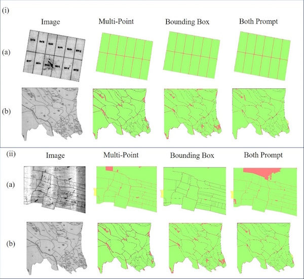
Figure 2: Visualization of prediction of three variations of prompts
of zero-shot segmentation of SAM on cadastral parcel extraction task
from historical scanned cadastral images (i) based on parcel density (a)
equally sized; (b) dense and variety of pixel; and (ii) based on
combination of parcel size and its eccentricity. Green pixels are True
Positive; red pixels are False Negative, and yellow pixels are False
Positive.
Additionally, the capability of zero-shot segmentation was evaluated
for all sizes of parcels, as presented in Figure 2(ii). Across all
parcel sizes, the mixed prompt approach outperformed individual base
prompts. In Figure 2-ii(a), both large and small parcels were accurately
extracted using all prompt types, particularly when the parcel shape
closely matched well-defined geometric forms, with an eccentricity value
near one. However, there was an observed underestimation in delineating
larger parcels with high eccentricity (i.e., where the length is
significantly greater than the width). Figure 2-ii(b) further
demonstrates that as parcel eccentricity increases, the performance of
zero-shot segmentation declines, irrespective of parcel size. This
finding suggests that the segmentation accuracy for parcels of different
sizes is strongly correlated with their eccentricity. The increase in
eccentricity introduces greater heterogeneity within the parcel shape,
which poses a challenge to SAM’s segmentation capability.
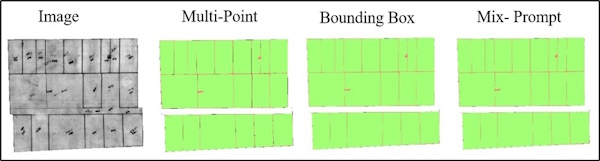
Figure 3: Visualization of prediction of three variations of prompts
of zero-shot segmentation of SAM on cadastral parcel extraction task
from historical scanned cadastral images based on different visibility
of parcel boundary. Green pixels are True Positive; red pixels are False
Negative, and yellow pixels are False Positive.
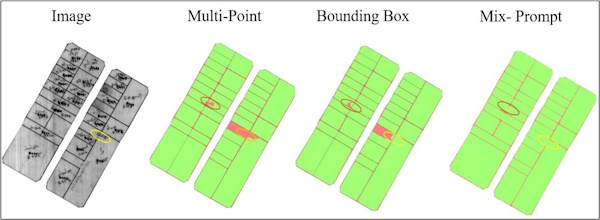
Figure 4: Visualization of prediction of three variations of prompts
of zero-shot segmentation of SAM on cadastral parcel extraction task
from historical scanned cadastral images based on different noise
levels. Green pixels are True Positive; red pixels are False Negative,
and yellow pixels are False Positive.
In the case of scanned images with a lack of clarity in the parcel
boundaries primarily due to suboptimal scanning processes and the use of
pencil marks during parcel subdivision, the results obtained are shown
in Figure 3. The clarity of parcel boundaries is a critical factor in
accurate delineation. To assess the impact of boundary clarity, the
zero-shot segmentation capability was tested across different levels of
line clarity in the scanned images. Notably, all prompt types produced
promising results in delineating parcels, even under varying degrees of
boundary clarity or ambiguity.
Some representative scanned cadastral map images exhibited
significant noise, both within and adjacent to parcel boundaries. Noise
within the boundary, excluding parcel numbers, did not negatively impact
the performance of SAM's zero-shot segmentation, as illustrated in
Figure 4. In these cases, the model was able to delineate parcels
accurately despite the internal noise. However, noise located adjacent
to parcel boundaries significantly reduced the accuracy of segmentation,
as shown by the red box in Figure 4. This adjacent noise interfered with
the model's ability to precisely delineate parcel boundaries.
Additionally, when faint boundary lines were accompanied by adjacent
noise, the segmentation was further compromised. In such cases,
illustrated by the yellow box in Figure 4, the model either failed to
properly delineate the parcels or mistakenly merged two adjacent parcels
into one. This highlights the negative impact of adjacent noise on
segmentation accuracy and the importance of clear boundary delineation
in scanned images.
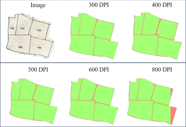
Figure 5: Visualization of prediction of zero-shot segmentation of
SAM on cadastral parcel extraction task from historical scanned
cadastral images scanned at different scanning resolution levels. Green
pixels are True Positive; red pixels are False Negative, and yellow
pixels are False Positive.
A common issue across all the experiments was the occurrence of false
negatives between parcels. This can be attributed to the fact that the
cadastral maps were scanned at a relatively low resolution (300 DPI),
where parcel boundary lines occupied only a few pixels, leading to
segmentation errors. To address this, the same cadastral map was scanned
at higher resolutions to assess the impact on mitigating boundary
underestimation. Surprisingly, increasing the scanning resolution did
not significantly reduce the occurrence of false negatives between
parcels, as shown in Figure 5. In fact, the delineation capability of
SAM further decreased with higher scanning resolutions. This reduction
in performance can be attributed to the increased heterogeneity
introduced by higher resolutions, which likely introduced more noise and
finer details, complicating SAM's ability to accurately segment parcel
boundaries.
In summary, our findings indicate that the combination of base
prompts consistently outperforms individual base prompts in the
zero-shot learning approach across all datasets. However, SAM's
zero-shot approach faces challenges when handling noisy data near
boundaries and areas with complex parcel configurations. Additionally,
the occurrence of false positives between segmented parcels remains a
persistent issue. These challenges highlight the need for integrating
Geographic Information Systems (GIS) with SAM, along with human
oversight, to ensure the creation of accurate and complete cadastral
databases.
4. Conclusion
In this study, we conducted a comprehensive analysis of the zero-shot
segmentation capabilities of the Segment Anything Model (SAM) for
cadastral data extraction from scanned historical cadastral maps under
various scenarios and complexities. Our analysis revealed that SAM's
different prompting methods (points, bounding boxes, and combinations)
performed notably well in most cases, except when dealing with noisy
data near boundaries and areas with complex parcel configurations. The
model demonstrated the potential to significantly reduce human workload
and error with minimal or no supervision. However, this initial
experiment was limited to exploring SAM's zero-shot capabilities. Future
research should focus on evaluating SAM's one-shot segmentation
capabilities as well as SAM-2 model, which may further enhance its
performance. Additionally, SAM has the potential to integrate with
diverse remote sensing data, such as UAV imagery, to quickly generate
segmentation outputs without the need for extensive training. This makes
SAM particularly well-suited for Nepal's varied geographic conditions,
especially in post-disaster scenarios like earthquakes or floods. By
incorporating SAM into existing GIS platforms and remote sensing
workflows, Nepal's cadastral system can be made more resilient to
natural disasters and ongoing land use challenges.
REFERENCES:
-
Gobbi, S., Ciolli, M., La Porta, N., Rocchini, D., Tattoni, C., &
Zatelli, P. (2019). New tools for the classification and filtering
of historical maps. ISPRS International Journal of Geo-Information,
8(10), 1–24. Link
-
Ignjatić, J., Nikolić, B., Rikalović, A., & Ćulibrk, D. (2018).
Ignjatić.pdf. 4617(Cd), 42–47.
-
Janssen, R. D. T., Duin, R. P. W., & Vossepoel, A. M. (2002).
Evaluation method for an automatic map interpretation system for
cadastral maps. 125–128.
Link
-
Kim, N. W., Lee, J., Lee, H., & Seo, J. (2014). Accurate
segmentation of land regions in historical cadastral maps. Journal
of Visual Communication and Image Representation, 25(5), 1262–1274.
Link
-
Kirillov, A., Mintun, E., Ravi, N., Mao, H., Rolland, C.,
Gustafson, L., … Girshick, R. (2023). Segment Anything. In
Proceedings of the IEEE/CVF International Conference on Computer
VisionProceedings of the IEEE/CVF International Conference on
Computer Vision (pp. 4015–4026).
-
Lukman Syahid, H. (2011). Land administration and disaster risk
management : case of earthquake in Indonesia. 91.
-
Mitchell, D. (2009). Reducing Vulnerability to Natural Disasters
in the Asia Pacific through Improved Land Administration and
Management. International Federation of Surveyors Working Week 2009,
Eilat, Israel, 3-8 May, (October 2010), 1–12.
-
Osco, L. P., Wu, Q., de Lemos, E. L., Gonçalves, W. N., Ramos, A.
P. M., Li, J., & Marcato, J. (2023). The Segment Anything Model
(SAM) for remote sensing applications: From zero to one shot.
International Journal of Applied Earth Observation and
Geoinformation, 124.
Link
-
Sapkota, R. K. (2012). LIS Activities in Nepal: An Overview in
prospect of DoLIAe. Nepalese Journal on Geoinformatics, 11, 23–28.
-
Zhao, Z., Fan, C., & Liu, L. (2023). Geo SAM: A QGIS plugin using
Segment Anything Model (SAM) to accelerate geospatial image
segmentation. Research Software.
Link
BIOGRAPHICAL NOTES
Sanjeevan Shrestha is a Chief Survey Officer at the Survey Department
with 13 years of experience under the Ministry of Land Management,
Cooperative and Poverty Alleviation. He currently also serves as the
Vice President of Nepalese Remote Sensing and Photogrammetry Society. He
holds a Master of Science degree in Geospatial Technologies from
Universidad Nova de Lisboa, Portugal and University of Munster, Germany
through Erasmus Mundus program and a Bachelor in Geomatics Engineering
from Kathmandu University, Nepal. His expertise includes remote sensing,
geospatial analysis, geo-statistics, and the applications of deep
learning and machine learning techniques.
CONTACTS
Sanjeevan Shrestha
Survey Department, Minbhawan. Kathmandu,
NEPAL
Tel. +9779865464752


