Article of the Month -
January 2008
|
Developing Cost-effective and Resilient Land Administration Systems in
Latin America
Grenville Barnes; USA
 This article
in .pdf-format.
This article
in .pdf-format.
SUMMARY
In this paper I briefly review the wealth of experience in Latin America
with initiatives to strengthen and modernize land administration systems.
The review shows that there is more experience with land administration
projects in this region than in any other. I go on to focus on the question
of costs associated with formalizing property in an attempt to find an
effective means of comparing costs across countries. I approach this by
looking at different ‘levels’ – starting with global budget figures, then
narrowing down to specific components and finally by examining the cost of
individual tasks required to formalize a parcel. A comparative study of
costs in 4 different regions of the world is described together with
preliminary conclusions at the global level. The issue of property
‘deformalization’ is also discussed with respect to transaction costs.
Recognizing that land administration systems, and the economic, social
and natural environments within which they operate, are continually
changing, I introduce Resilience as an appropriate analytical framework
through which to examine changing systems.
Resilience has evolved as a more nuanced framework for understanding the
sustainability of socio-ecological systems. Unlike previous approaches, it
accepts that a system will always be subject to disturbances, whether they
are due to climate (hurricanes), policy and political administration
changes, or demographic shifts due to urbanization or migrant labor markets.
RESUMEN
Esta exposición revisa la gran experiencia en América Latina
sobre las iniciativas para fortalecer y modernizar los sistemas de
administración de tierras. El repaso indica que hay mas experiencia en este
region con pryetos de adminsitracion de tierras que en cualquier otra region
del mundo. El primer parte enfoque en la cuestion de costos vinculado a la
formalización de la propiedad con el motivo de identificar medios aptos para
comparar costos entre diferentes paises. Esta analisis incorpora el estudio
de costos en diferentes niveles – empezando con costos presupuestos
globales, despues enfocando el nivel de componentes individuales y
finalmente se examina los costos para diferentes actividades en el proceso
de formaliza una propiedad. Se discutir un estudio de costos en cuatro
diferentes regiones del mundo y ciertos conclusiones preliminares al nivel
global. Esta discusión incluya tambien la cuestion de ‘deformalización’ de
propiedad con respeto a los costos transaccionales.
Reconozco que sistemas de administración de tierras, y el
ambiente económico, social e ecológico en que el sistema opera, siempre esta
cambiando, se introduzca el Resiliencia como una rama analítica apropiada
para analizar los dinámicos del sistema.
Finalmente, examinaré los sistemas de administración de
tierras a través del lente de ‘resilencia.’ La resilencia se ha desarrollado
como un marco matiz para examinar la sostenabilidad de sistemas
socio-ecologico. A diferencia de previos acercamientos, éste acepta que el
sistema siempre esté sujeto a disturbios, sea a consecuencia del clima
(huracanes), cambios políticos o administrativos, o a desplazamientos
demográficos a causa de la urbanización o migración de mercados laborales.
1. INTRODUCTION
It was appropriate to hold the recent regional FIG conference in Costa
Rica as this country was one of the first countries in the region to
implement what today would be regarded as a land administration project. The
1964 USAID-funded “cadastral survey project” was the pioneer land project in
Central America (Goldstein 1974). The focus of that project was to improve
the property tax system and complete a topographical mapping project which
would provide information for tax, land planning and development purposes.
Similar projects followed soon afterwards in Panama, Nicaragua and
Guatemala, all focused strongly on property taxes, with additional
components addressing natural resource management and land titling in some
cases.
During the 1980s the World Bank began to fund several large land projects
in Latin America and elsewhere. The first two to be completed were the
projects in Thailand and NE Brazil (Holstein 1993). The Thailand “land
titling project,” the ‘mother’ of all land titling projects, started in
1985. This has been a significant project for two reasons. Firstly, it is
regarded as a highly successful project. Secondly, it has been the proving
grounds for the evolutionary theory of land rights (ETLR) which served as
the underlying rationale for many of the subsequent land projects that
followed in the next two decades. Many of the assertions or hypotheses
internal to the ETLR have been empirically proven using the experience of
Thailand (Feder et al 1988). Data was gathered and analyzed to demonstrate
the correlation between titling and access to credit, reduction in property
disputes, facilitation of the land market, and increasing land values (Feder
and Nishio 1996). Based partly on these positive outcomes in Thailand, land
administration projects proliferated throughout the developing world.
Within Latin American the North East Brazil “national land administration
project” was the forerunner of a series of land administration projects in
the region (World Bank 1985). USAID continued to fund land titling projects
throughout the 1980s, including the “land titling projects” in Honduras and
Ecuador (USAID 1985). However, the most successful of the USAID-funded
projects may have been the “Land Titling and Registration Project” in St.
Lucia (USAID 1983). The island-wide land adjudication process was completed
within the originally scheduled time – this by itself may be a unique
achievement amongst land administration projects which invariably stretch
beyond the time frame set out in the project design.
The World Bank has funded land administration projects throughout Latin
America, and even by 1998 a study of World Bank projects revealed that there
were “..115 projects with land-related activities in the Bank’s
portfolio…[and] ..of those, about 40% are in Latin America.” (World Bank
1998, p. 10). Subsequent land administration projects ensued in Bolivia
(1995, 2001), Brazil (1995), Guatemala (1996, 1997), Honduras (2000), Panama
(2000), Nicaragua (2002), Honduras (2003), and El Salvador (2005).
The Inter-American Development Bank has also played a lead role in
funding land administration projects in Latin America and the Caribbean
especially over the past decade – including Trinidad and Tobago (1995),
Nicaragua (1995), Dominican Republic (1997), Belize (1997), Colombia (1997),
Honduras (1998), Jamaica (1999), Costa Rica (2000), Ecuador (2001), Panama
(2002), Brazil (2002), Mexico (2003), Bolivia (2003), Paraguay (2003), and
the Bahamas (2004).
While this is not a complete list of projects it does illustrate the huge
amount of investment that has gone into land administration and property
formalization and therefore the wealth of experience in the region. In the
following section of this paper I bring this experience to bear on certain
key land administration issues, namely the question of costs.
2. COMPARATIVE ANALYSIS OF COSTS
While significant resources have been invested by the donor community in
modernizing land administration infrastructure around the globe, there has
been little systematic discussion and documentation of actual costs. Better
understanding of the underlying issues and the trade-offs involved in
choosing among different technical, legal and institutional options of
providing land administration services is needed. Even though the World
Bank, IDB and other donors have long supported titling interventions all
over the world, surprisingly little is known about the actual costs of such
interventions, both in terms of project implementation and comparative
transaction costs once the new systems are in place. Until recently, little
effort has been made to disaggregate costs into the specific activities
required to formalize a piece of land.
In reviewing previous studies that dealt with costs, there are several
worth mentioning. In 1985 Janice Bernstein at the World Bank documented a
study she carried out entitled “The costs of land information systems.”
(Bernstein 1985) She compiled information on the topic through “a review of
the literature and illustrative programs as well as discussion with experts
in the field…” (p. 5) She concluded early on that “..there is a great need
for coordinated research among international organizations and training
institutions focusing on the economics of land information..” (p. 11) The
report focused largely on the potential for lowering the cost of cadastral
surveys through inertial surveying and GPS, which were just becoming
operational at that time. It also focused on methods for estimating the cost
of photogrammetric mapping. A fully operational GPS/GNSS system, the higher
precision of today’s satellite imagery, and airborne GPS have essentially
reduced the value of this information to one of historical interest. The
study also contributes little towards the development of a comparative
methodology.
Two years later in 1987 a symposium entitled “The Economics of Land
Information” was held in Baltimore, MD, under the auspices of the Institute
of Land Information (ILI 1987). This issue was topical in the US at that
time as GIS was becoming mainstream and county offices were in the process
of digitizing their land information. Approaches discussed at the ILI and
other forums at that time included: (i) an avoided cost approach, where
benefits are construed as the avoidance of downstream costs by making
upstream (often public) investments in, for example, geodetic infrastructure1
– creating the information now means that it does not have to be repeated at
a later time; (ii) a ‘use and value’ approach whereby benefits are gauged
relative to frequency of use – information that is used more often has more
value even though it may have cost the same to produce. The ‘avoided cost’
approach may have some value, but it focuses more on future costs than more
defensible present or past costs. However, both approaches are not that
useful for developing a comparative methodology as they focus more on
benefits than costs.
Other cross-country studies include work done by Dale and McLaughlin
(1988) and Holstein (1993). Their breakdown of costs by activity is compared
with that given by Bernstein (1985) in Table I below.
TABLE I. Percentage Distribution of Costs by
Activity
|
Source |
Mapping |
Adjudication |
Surveying |
Registration |
Institutional
Strengthening |
|
Bernstein2 |
38% |
29%3 |
|
6%4 |
13% |
|
Dale/McLaughlin |
20-25 % |
30-50 % |
20-25% |
10-15% |
|
Holstein |
24% |
18% |
22% |
23% |
13% |
1 See Epstein
and Duchesneau 1984
2
Based on the NE Brazil Project Costs. Other components included
Support for Land Restructuring” (9%), Project Administration (4%)
and Studies (1%)
3 Land Tenure Identification
4
Cadastre Implementation and Titling
None of these three studies provide a robust comparative analysis
methodology, although they do suggest focusing on activities such as
mapping, adjudication, surveying, etc. Even this can be problematic as
surveying may sometimes be included as a sub-component of adjudication (Dale
and McLaughlin 1990).
Gross unit costs are typically used to compare costs across different
projects, without taking into account the significantly different contexts
and approaches. As a result, cadastral and land registration interventions
are often viewed as expensive activities that do not generate sufficient
benefits to justify their costs. Furthermore, no systematic template exists
for collecting data across different countries. The cost issue came to a
head in a 2001 e-conference on “Lessons Learned in Land Administration”
organized by the World Bank (Deininger 2003; Barnes 2003). One participant
shared information on the Peruvian Titling Project (PETT) which had reduced
the cost of formalizing a parcel to approximately $47 per parcel. In
response to this, another participant countered that in Eastern Europe they
were titling at the cost of $1.05 per parcel! Either these two participants
were talking about two completely different processes and products or else
the contextual setting of these two cases was incomparably different.
Clearly there was a need to ‘unpack’ these numbers and develop a framework
for comparing the same process or product.
Following this conference we developed a template of questions and tables
that could be administered at the country level. We approached this by
identifying costs at three different levels – starting from global project
figures and then considering costs at the level of project components, and
finally examining specific costs entailed in converting a parcel of land
into a formal registered property. We also recognized the need to
contextualize these studies so that the cost figures could be considered
against the specific context within which the project was being implemented.
Subsequently, the template was expanded to include an analysis of the
effectiveness of the land administration system. This ‘template’ was then
applied in seventeen countries in four different regions - Latin America and
the Caribbean (El Salvador, Peru, Bolivia, Trinidad and Tobago), E. Europe
and Central Asia (Armenia, Kyrgyzstan, Moldova, Latvia), Asia (Indonesia,
Karnataka, Philippines, Thailand) and Africa (Ghana, Mozambique, Namibia,
South Africa, Uganda). Subsequently, four regional reports were prepared
that summarized the country-level reports (Barnes 2002; Adlington 2002; Land
Equity 2003; Augustinus 2003). Finally a global report was prepared
comparing all countries across the four regions (Land Equity 2007).
Instead of drawing on the general data for the global comparison, I have
widened the LAC scope by considering 11 projects within the region. The data
are drawn from the many project documents I have in my own library as well
as others which are listed on the LandNet Americas portal.5
TABLE
II.
Global Comparison of per parcel Costs - Total Project Costs/Total Parcels
6
|
Project |
Total Budget
US$M |
# Parcels |
Dates |
$/parcel |
Area (MHa) |
$/ha |
|
Peru (PETT1) |
36.5 |
1,000,000 |
1997-2002 |
37 |
na |
na |
|
El Salvador
|
70 |
1,700,000 |
1996-2005 |
41 |
1.9 |
37 |
|
Peru (PETT2) |
46.7 |
170,000 |
2003-2007 |
62 |
3.6 |
13 |
|
Costa Rica (IDB) |
92 |
520,000 |
2002-2007 |
177 |
na |
na |
|
Bolivia (PNAT) |
28 |
10,000 |
1995-2003 |
2800 |
3.7 |
8 |
|
Bolivia (St.
Cruz) |
15 |
140,000 |
2006-2010 |
107 |
na |
na |
|
Ecuador (PRAT) |
16 |
135,000 |
2003-2007 |
119 |
0.6 |
27 |
|
Nicaragua
(PRODEP) |
2.4 |
90,000 |
2003-2010 |
27 |
1.4 |
2 |
|
Belize (LMP) |
8.9 |
40,000 |
2003-2006 |
223 |
na |
na |
|
Panama (LARP-IDB) |
72.3 |
120,000 |
2003-2008 |
603 |
0.75 |
96 |
|
Panama (ProNAT) |
47.9 |
80,000 |
2001-2007 |
599 |
1.1 |
44 |
|
Average |
40 |
420,000 |
|
436 |
1.9 |
21 |
|
Average (without
PNAT) |
41 |
|
|
200 |
|
|
|
This kind of comparison is of minimal use partly because
it assumes that the total budget can be associated with the number of
parcels that are either titled or regularized in some way. Costs associated
with legal reform, institutional strengthening, equipment purchases, etc.
are examples of costs that have no relation to parcels, but are still
included in the comparative figures given in Table I. Although the parcel is
the unit of choice when assessing the extent and cost of surveying and
regularization, its cross-scalar nature produces unwelcome complexities. A
‘parcel’ may include any of the following tenure units:
-
small urban lots (e.g. 20m x 30m)
-
peri-urban lots
-
small agricultural parcels (minifundias)
-
medium rural parcels
-
large rural parcels
-
large communally-held parcels (e.g. indigenous
communities)
The scale of a parcel may therefore vary from a small
urban lot to a communal property that may approximate the size of a
municipality. Additionally, at the project design stage the number of
parcels in a jurisdiction or area is often the weakest data available. The
whole motivation for adjudication and titling stems from the fact that there
is no reliable formal parcel information in the registry or cadastre.
Therefore parcel information may be available at the end of the project, but
during design it can only be inferred through estimating average parcel
sizes or consulting census data.
Costs are also estimated on an area (per hectare) basis?
Using the project documents as a source again, those costs that are
available are shown in Table I. Four out of the eleven projects in Table I
do not list area to be titled or regularized in the project document. In the
remainder, the per hectare costs range from $2/ha in Nicaragua to $96/ha in
Panama with an average of $21/ha. This approach to unit costs suffers from
the same problem as mentioned above – it assumes that the cost per unit area
is uniform, ignoring the fact that the multiple scales of parcels contradict
this especially in the fieldwork component. Those projects that contain
several large parcels, such as indigenous communities, skew the cost per
hectare numbers (such as in Nicaragua). It is therefore necessary to look
deeper than these global figures if we are to effectively compare these
projects. It may be more productive to consider the costs of an average size
parcel.
At a more specific level we can examine costs by focusing
on procurement type. Once again, this data is easily available in project
documents, and the results for a small sample of countries is given in Table
III below
TABLE III. Breakdown of Budgeted Costs by Procurement
for Five Countries
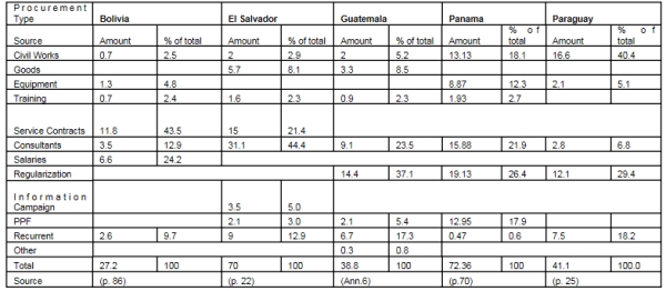

FIGURE 1.
Percentage of Budget by Procurement Method
Figure 1 shows that two crucial elements underlying the
success of land administration initiatives – training and
information/communication – rank last in terms of “procurement type.”
However, it is risky to draw any conclusions from these data partly because
several categories in Figure 1 overlap. Training, for example, may be
treated under a separate category in some projects, while in others it will
be included under institutional strengthening. Adding to the complexity of
comparative costs are differences in technologies, variations in
implementation strategies (in-country or through international bid), and
differences in the quality of existing cadastral and registration data,
access and boundary complexity.
Finally, the third level that we examined in the
comparative cost study was the cost for each task required to convert a
parcel from informality into a fully registered property (see Table IV).
TABLE IV Breakdown of Costs to Formalize a Parcel (Land Equity 2007, p.
94)

The number of gaps in the above table shows either that
countries are using different approaches that do not include all of the 19
tasks listed in Table IV above and/or costs are not always reported at this
fine a resolution. It is also important to distinguish between urban and
rural as the Peruvian case indicates rural parcels can cost almost five
times as much as urban parcels.
Looking through even a finer lens at a single cost
sub-component – cadastral survey (#7 in Table IV) – reveals the extent to
which cost can vary at this micro level. Cadastral survey costs for a single
parcel can vary considerably depending largely on four factors: the quality
and scope of the recorded cadastral information, the nature of the terrain,
land value, cadastral evidence (e.g. original monuments/markers, fences)
encountered in the field. In Figure 2 below I have related how these factors
combine to either increase or decrease the survey costs.

FIGURE 2. Four Factors affecting
Cadastral Survey Costs
If land
adjudication (saneamiento) is to be done systematically (barrido) across an
area then the expectation is that this will generate economies of scale,
thereby dropping the per parcel costs. Furthermore, additional efficiencies
can be gained by using methodologies based on GPS which, unlike conventional
approaches, does not require line of sight between all surveyed points. To
what extent do these two factors – economies of scale and the use of GPS –
reduce the survey costs. We were faced with this question in designing the
IDB land administration project in Belize in the mid-1990s. At that time
private surveyors estimated their survey fees on the basis of this simple
formula: US$200 √ area of parcel in acres. In other words, the survey fees
for a parcel of 20 acres would be approximately $900.
Drawing on the experience of the South African cadastral surveying system,
which for more than 60 years had a tariff of fees that incorporated a factor
to account for increasing economies of scale as more parcels were surveyed,
the following figures can be computed in the context of Belize.
TABLE V. Cadastral Survey Fee Structure
accounting for Economies of Scale
|
Number of
Parcels |
Scale Factor |
Factor applied
to Belize Survey Costs7
|
|
1 |
1 |
$900 |
|
2 |
0.7 |
630 |
|
3 |
0.6 |
540 |
|
4 |
0.5 |
450 |
|
5 |
0.4 |
360 |
|
10 |
0.4 |
360 |
|
20 |
0.3 |
270 |
|
100 |
0.3 |
270 |
|
200 |
0.2 |
180 |
|
400 |
0.2 |
180 |
|
1000 |
0.2 |
180 |
7
Assuming an average cost of
US$900 for an individual 20 acre parcel
The scaling factors therefore bring the per parcel costs down to
$180 per parcel assuming that a surveyor is contracted to survey at
least 200 parcels. In addition to these economies of scale,
efficiencies through the use of GPS were estimated to further reduce
the measurement and mapping time by a factor of four. We therefore
concluded that the combination of scale economies and technological
efficiency could reduce the per parcel costs down to as little as
$90 per parcel (Barnes 1995).
Given the large number of variables in just the cadastral
surveying, adjudication, land titling and land registration costs
for formalizing a parcel of land, it is not surprising that we are
faced with an “apples and oranges” type of comparison of costs. I
have just considered initial registration costs in this section, but
there are other costs – especially those relating to subsequent
transactions – that may be even more crucial to the success and
sustainability of a land administration system.
3. TRANSACTION COSTS
Informality results when landholders perceive that the costs and
benefits of the formal system do not match those of the informal
system. In other words, landholders who believe that the costs of
formalizing transactions outweigh the perceived benefits that flow
from such formalization will conduct their transactions outside the
formal system. This is particularly true when informal transaction
costs are further reduced because the parties to the transaction are
members of the same family.
Douglass North’s work on transaction costs, property rights and
institutions has perhaps been the most influential work in terms of
providing a comprehensive approach towards analyzing this area.
North distinguishes between transformation and transaction costs:
The total costs of production consist of the resource inputs of
land, labor and capital involved both in transforming the physical
attributes of a good … and in transacting – defining, protecting and
enforcing the property rights to goods.. (North 1990, p. 28)
When entering into a transaction, such as purchasing a parcel of
land, costs are incurred in the search for information about the
land (quality, value, history, etc.) and the seller’s valid claim to
the land (title, transaction history, third-party claims, etc.). As
North explains:
The costliness of information is the key to the costs of
transacting, which consists of the costs of measuring the valuable
attributes of what is being exchanged and the costs of protecting
rights and policing and enforcing agreements. (p.27)
I
believe that high transaction costs following subsidized titling
efforts are causing substantial ‘de-formalization’ of titled
property. Based on research in St. Lucia and key informant
interviews in the field in numerous countries, we have observed a
tendency for titleholders not to register transactions after they
have received title. Our research in St. Lucia revealed that
approximately 28% of the register was out of date some two decades
after an island-wide titling project, mainly due to informal
generational transfers within families (Griffith-Charles 2004;
Barnes and Griffith-Charles 2006). We believe that the situation in
many other countries will be substantially worse than this.
Comparing the de facto and the de jure situation of land parcels
is also problematic. Collecting de jure data may simply entail a
visit to the registry to extract data on the formal situation.
However, even though most registries in Latin America are ‘registros
publicos’ they most often restrict public access. Access to property
registries may be limited only to those individuals with a valid
interest in a transaction. There is often a fear that documents will
be defiled unless they are handled by competent public officials. On
the other hand, if one does gain entry into the registry large
amounts of data on transactions can be obtained in a relatively
short period of time. Not so with de facto data. This requires more
research and a well-designed sampling strategy that allows
researchers to not only select a representative sample of the total
parcel population but also to be able to link that parcel with the
relevant information in the registry and/or cadastre. Without
reliable geographic information for the registered parcels this can
become extremely challenging.
We can also conclude that institutional differences amongst
countries, including rapid changes in political administration,
levels of decentralization, etc all need to be contemplated when
examining costs. The recent focus on land for the poor also raises
the issue of affordability. We currently do not have a good idea of
what poorer landholders can afford to pay for formalizing subsequent
transactions. Finally, in order to come to grips with land
administration dynamics we need to understand the processes of
change that are occurring in the surrounding environment, in the
landholding population and in the infrastructure and services that
meld together the social-ecological system. Resilience has emerged
as a useful approach towards understanding system change.
4. A RESILIENCE APPROACH
Phenomena such as global warming, increases in natural disasters
such as hurricanes and unpredictable market dynamics remind us daily
that our planet is a highly complex system. Through drawing
disciplinary boundaries – defining social sciences, natural
sciences, etc. - we have in effect parsed our world into more
manageable pieces. However, in the process we have disassociated
social systems from ecological systems and made it more difficult to
understand complex human-environmental interactions.
Over the past decade ecologists and others have defined a
resilience approach to study complex dynamic human-environment
interactions (see, for example, Gunderson and Holling 2002;
Carpenter et al 2004; Anderies et al 2006; Walker and Salt 2006).
Resilience “stresses the importance of assuming change and
explaining stability, instead of assuming stability and explaining
change.” (Folke et al 2003, p. 352) A resilience approach recognizes
that there is no single stable state in a social-ecological system
(SES), but that the system is exposed to different ‘shocks’ that
challenge its fundamental identity and make it dynamic. A resilient
system is able to absorb shocks and adapt without changing its
fundamental structure and function (Gunderson and Holling 2002).
Shocks may be stochastic (e.g. tsunami, land policy reform, major
macro-economic changes), cyclical (flooding), or occur at different
temporal scales – decadal (e.g. drought), annual (e.g. hurricanes,
labor migration) or at smaller time scales.
Through funding from the National Science Foundation, we are
investigating the resilience of social-ecological systems in the SW
Amazon. We focus on connectivity as the primary agent of change,
specifically the trans-oceanic highway that is being paved and will
eventually link the Pacific and Atlantic Oceans. The highway will
radically change the connectivity in the region of our research,
which includes the states/departments of Made de Dios (Peru), Acre
(Brazil), and Pando (Bolivia) and is commonly known as the MAP
region. We hypothesize that resilience will increase as connectivity
improves; however, at some level of connectivity it will begin to
become less resilient due to its over-connectedness and consequent
over-dependence on external factors. In short, a graph of resilience
(Y axis) and Connectivity (X axis) will reveal an inverted U shape.
One of the many challenges of operationalizing resilience
analyses is defining what constitutes the ‘fundamental structure and
function’ of a system. In our own research at the University of
Florida we have attempted to do this by examining social, ecological
and social-ecological measures of this identity. Within the context
of land tenure this may be construed as the land administration
framework and the decisionmaking with respect to land and its
associated resources. What does it mean to focus on change within a
land administration system? At a basic level, cadastral and
registration systems are constantly changing as the land market
operates and property is sold and new parcels are created through
subdivision. All successful land administration systems should be
designed to accommodate this constant change, otherwise they will
quickly become out of date. This suggests that the focus in land
administration should be on those parcels that are undergoing the
most change (parcels changing hands or being subdivided) or which
may be susceptible to change (parcels on the frontier). There is one
change that we know will occur in all systems and that is the
eventual death of the landholders. The mechanism for dealing with
this change, namely inheritance, is presenting a key challenge to
the maintenance of land administration systems in the developing
world.
Resilience is best measured when a system has been subjected to
some shock which challenges its continued existence. Extreme shocks
that impact land administration may include natural disasters (e.g.
hurricanes, floods) or anthropogenic fire. A resilient land
administration system is one that can most quickly return to
‘normal’ operation after a shock. If the shock pushes the system
beyond a certain threshold, it will “flip” into a fundamentally
different system. Within the Amazon region, for example, we can
observe indigenous forest areas flipping into treeless ranches which
are composed of entirely different structures (owners, resources)
and processes (land uses). Within the land administration context
this may not be as dramatic, with, for example, a flip from
registration of deeds to registration of title.
There is a recent but growing interest in the resilience of land
administration systems in the face of natural disasters such as
hurricanes and tsunamis. UN Habitat and others are realizing that
the resilience of land administration system and how it is governed
play a key role in recovery and reconstruction efforts following
natural disasters. The resilience framework is highly appropriate
for trying to not only understand the role that land administration
systems have played in past disasters, but more importantly how we
can strengthen these systems to better support recovery and
reconstruction in future disasters.
REFERENCES
-
Adlington, G. (2002).
Comparative Analysis of Land Administration Systems - ECA Regional
Paper. Unpublished. 21p.
-
Anderies, J., B.Walker, and A. Kinzig (2006).
“Fifteen weddings and a funeral.” Ecology and Society, 11(1): 21
-
Augustinus, C. (2003).
Comparative Analysis of Land Administration Systems - Africa Regional
Paper. Unpublished. 26p.
-
Barnes, G. (1995). “An
Assessment of Land Tenure and Land Administration in Belize.”
Unpublished Report, 55p.
-
Barnes, G. (2002).
Comparative Analysis of Land Administration Systems - Latin America and
the Caribbean Regional Paper, Unpublished. 18p.
-
Barnes, G. (2003).
“Lessons learned: An evaluation of land administration initiatives in
Latin America over the past two decades.” Land Use Policy
Journal, Vol. 20/4, pp. 367-374
-
Barnes, G. and C.
Griffith-Charles (2006). "Assessing the Formal Land Market and
Deformalization of Property in St Lucia." Land Use Policy Journal
-
Bernstein, J. (1983). The
costs of land information systems. Water Supply and Urban Development
Department, World Bank.
-
Carpenter, S., B. Walker,
J. Anderies and N. Abel (2004). “From Metaphor to Measurement:
Resilience of What to What? Ecosystems, 4: 765-781
-
Deininger, K. (2003).
Land Policies for Growth and Poverty Reduction. World Bank Policy
Research Report, World Bank and Oxford University Press, Washington,
D.C.
-
Dale, P. and J.
McLaughlin (1988). Land Information Management. Clarendon Press, Oxford.
-
Epstein, E. and T.
Duchesneau (1984). The Use and Value of a Geodetic Reference System.
Rockville, Maryland: National Oceanic and Atmospheric Administration,
National Geodetic Information Center.
-
Feder, G., T. Onchan, Y.
Chalamnong and C. Hongladarom (1988). Land Policies and Farm
Productivity in Thailand. World Bank Research Publication, Johns Hopkins
University Press, Baltimore.
-
Feder, G. and A. Nishio
(1996). “The Benefits of Land Registration and Titling: Economic and
Social Perspectives.” Paper presented at International Conference of
Land Tenure and Administration, Orlando, FL, Nov 12-14.
-
Folke C., J. Colding, and
F Berkes. (2003). Synthesis: building resilience and adaptive
-
capacity in
social-ecological systems. In Navigating social-ecological systems:
-
building resilience for
complexity and change (F. Berkes, J. Colding and C. Folke, eds.),
Cambridge University Press, Cambridge, U.K. pp. 352-387
-
Gunderson, L. and C.
Holling (2002). Panarchy: understanding transformations in human and
natural systems. Island Press, Washington, D.C., USA.
-
Goldstein, B. (1974).
Inter-Country Evaluation of Cadastral Programs – Costa Rica, Guatemala,
Nicaragua, Panama. AID, Bureau for Latin America, Washington, D.C.
-
Holstein, L. (1993).
Review of Bank Experience with Land Titling and Registration.
Unpublished Report, World Bank, Washington, D.C.
-
ILI (1987). The Economics
of Land Information: A Symposium of the Institute of Land Information.
Baltimore, MD. 78p.
-
Land Equity (2003).
Comparative Analysis of Land Administration Systems – Asia Regional
Paper. Unpublished. 16p.
-
Land Equity (2007). Land
Administration Reform: Indicators of Success and Future Challenges.
Agricultural and Rural Development Discussion Paper 37, World Bank,
Washington, D.C.
-
USAID (1983). Caribbean
Regional Project Paper: St. Lucia Agriculture Structural Adjustment.
Project 538-0090. Washington, D.C.: United States Agency for
International Development, International Development Cooperation Agency.
-
USAID (1985). Ecuador
Land Titling Project. Project Paper. USAID, Washington, D.C.
-
Walker, B. and D. Salt
(2006). Resilience Thinking: Sustaining Ecosystems and People in a
Changing World. Island Press, Washington.
-
World Bank (1985). Brazil
National Land Administration Project, North-east Region Land Tenure
Improvement Project. Staff Appraisal Report, World Bank (LAC Region),
Washington, D.C.
-
World Bank (1998).
Guatemala Land Administration Project. Project Appraisal Document
CONTACTS
Greenville Barnes
Associate Professor
University of Florida
406B Reed Lab
Gainesville FL 32611
USA
Tel + 1 352 392 4998
E-mail: gbarnes@ufl.edu


