The built heritage is a fundamental element of the public space. It
is part of the memory of places; it is the history of places represented
materially and often-beautiful iconic city landmark. For these reasons,
among others, cities that preserve this built heritage with intrinsic
rare value are highly pursued by the tourism industry, because they
constitute financial profit and economic growth. These sources of income
are frequently a factor in balancing public finances and support this
urban inherency. Today, the diversity of mobile platforms providing
access onsite to real-time geographic information and the possibility of
supporting Apps based on Augmented Reality enable, what we can call, the
expansion of public space and their cultural heritage value. The Apps
can be understood as dematerialized extension of the public space and
their cultural/historical value. The recreation of the public space with
heritage value (physical and limited) gives place to the virtual/mixed
public space, leading to what we can call smart public space
(an intergenerational interaction in the combination of paper maps or
other objects, with unlimited virtual information, supported on mobile
platforms) and as a consequence increases also the "ubiquity of cities".
The development of 3D models of urban objects implanted in public space,
using land surveys and UAV, and its incorporation in Apps for the
conceptualization of mixed reality environments, enhance the value of
urban heritage and promote the virtualization of cities. This idea will
support the demonstration of the prototype Lx_W App, developed for the
Águas Livres Aqueduct System in Lisbon, aqueduct that is one of the most
important landmarks of the Portuguese capital.
1. INTRODUCTION
The Smart City concept fills many of today's discourses on cities.
This concept is closely associated with Information and Communication
Technologies, although it is not exclusive. In fact, the concepts of
city efficiency, of intelligent cities, of strategic governance
capacity, among other concepts, are present in the discourses that we
can call non-technological discourses. In this circumstance, we can
admit that we are in the presence of political discourses. In any case,
whether it is technological or political speeches, what is relevant in
our opinion is that the concept of Smart City is insufficient, as Carlo
Ratti (2014) refer in a popular article, "The Smart City is not enough.
How could real-time data awaken the humanity in our buildings and public
spaces?". Within this context and considering the way we see the
relations between the city and the technology, we propose the following
idea alignment: what exists is a Smart Public Space that results from
the combination of "Human Sensors (HS) + Technology (Tech)" (Figure 1).
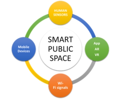
Figure 1 - Smart Public Space: Human sensors (HS)
+ Technology (Tech)
There is a Smart Public Space when there is a combination of HS +
Tech. HS are in physical, tangible, sensitive interaction with real
space. Hence an internal representation of this real space. Using Tech
(mobile devices, Apps, AR, VR, Wi-Fi signals) the HS enrich these
internal representations of public space, itself enhanced by enrichment
with virtual data. In this context, we can admit that there is a Smart
Public Space when there is convergence between the physical public space
and the virtual public space resulting from the HS + Tech interface.
If we accept the ideas above, we can look at the built heritage as an
element of the urban public space, combined in the following forms:
-
Built heritage and memory of places. The built heritage
is a space of memory; memory in overlapping, as if structured in layers
(due to the passage of time) and in fusion (for example, of
architectural styles, forms, methods and construction materials). All
built heritage has a narrative, synthesizes collectively shared
representations. Many of these representations remain in time, they are
part of the cities and the public space that compose them; are
historically appropriate identity and identification references. It is
often said that "every stone speaks" when we observe a building with
patrimonial value. We can affirm that the "whole" of a historical
building contains a narrative that can be enriched with information
inherited (architectural description, engravings, photos, ambiences,
etc.) structured on mobile platforms.
-
Built heritage and public space. Buildings with historical
value, as well as all other buildings, are part of the architectural
composition of the city and of the places in general. In this context,
the city is understood as an open landscape constituted by
three-dimensional pieces in an organized environment of which the open
spaces are part. Many of these open spaces are public: squares, farmer's
markets, downtown shopping malls, public parks, playgrounds, greenways,
waterfronts, etc. This public space is the place of sociability
manifestations such as walking, talking, studying, shopping, interacting
with others. The built heritage is a fundamental element of the public
space. On the one hand, as we have mentioned, it is part of the memory
of places; on the other hand, constitutes a dimension of the history of
the places represented materially. For these reasons, among others,
cities with rare built heritage are highly valued by the tourism
industry because they are sources of financial income. These sources of
profit are often a factor in balancing public finances.
- Built Heritage and Augmented Reality. The decade of
nineties of the 20th century were marked by the emergence of Virtual
Reality. The second decade of this century lives the Augmented
Reality. The overlay in "synchronous time" of virtual images with
elements of tangible reality is becoming an unprecedented social,
cultural and tourist practice. Today, the diversity of mobile
platforms providing access to real-time geographic information
(synchronization) and the ability to support Apps (understood as
data and technology that supports space-time extension) built on
Augmented Reality enable what we can call of expansion of the public
space with patrimonial or other value; ease the synchronization
between physical public space and virtual public space. Again, we
emphasize that Apps can be understood as the dematerialized
extension of the public space with patrimonial value. The recreation
of the public space with patrimonial value (physical and limited)
also gives place to the virtual public space and leads to what we
can call smart public space.
In the context we have just presented, we propose a new concept:
Augmented Valuation of Cultural Heritage, as a result of virtual
georeferenced data added to the real world applied to cultural heritage
using mobile technology (Figure 2).
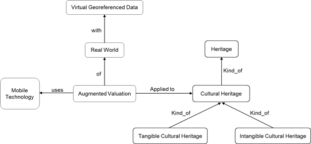
Figure 2 - New concept proposal: Augmented
Valuation of Cultural Heritage
This concept is outlined in the figure 2 and is composed of three
fundamental parts: i) the tangible cultural heritage; ii) the intangible
cultural heritage; both being part of the cultural heritage; and iii)
the augmented valuation results from the combined use of virtual data
and mobile platforms. This combined use increases the value that the
built heritage has. It extends the memory and qualities of this
heritage; increases its value because it introduces the possibility of
constructing a narrative. In what way can we answer the question: "How
can 3D models and augmented reality visualization based on mobile
platforms enhance the value of urban heritage?". Presently, we use of
public space resorting to mobile platforms has been a reality for some
years. In such a way that the urbanism of the future will consider this
new reality. There is no better way to answer the question, nor to
exemplify what we have just said, than to resort to the short story of
implementing a mobile App.
2. SCHEMATIC APPROACH TO MODELLING, REPRESENT AND VISUALISE 3D
OBJECTS IN AN AR ENVIRONMENT
Urban planning is intimately connoted with spatial relationships
between objects, buildings, blocks, streets, neighbourhoods, and cities,
and often 2D representations are considered insufficient to address real
3D planning problems, especially at the scale (in area and height) of
the modern city (Yin, 2010). 3D representations increase the engagement
of the user, making easier to understand and participate by visualizing
interactively, for example, volumes, textures, shadows, sights and their
relation. This principally occurs because of its high level of
similarity to reality and how humans perceive the world, congregating
detailed information and volume property, stimulating more enthusiasm
and simplifying creative solutions for detected problems after a
walk-drive-fly-through re-presentation (embodying the user in that
environment or presence), improving understanding and communication. 3D
representations and analysis tools are more adequate for volume
variation and enriching spatial representations.
Allowing to collect data to generate diverse types of geographical
information products, and particularly very detailed 3D point clouds and
models, practically on demand, Unmanned Aerial Vehicles (UAV) has
introduced a flexible, low-cost and rapid response as an alternative to
other traditional methods, such as ground acquisitions and manned
vehicles. 3D point cloud data automatically generate 3D models,
including Digital Terrain Models (DTM - simple terrain), Digital Surface
Models (DSM - including the elevations of objects above the ground), and
3D models (from isolated or collective objects). 3D point clouds are
mostly generated directly from a laser scan or through stereo image
matching, processing imagery algorithms by overlapping (terrestrial or
airborne). This means that it is possible to acquire relevant urban
parameters at low-cost, from 3D point cloud data acquisition (Tenedório
et al., 2014).
Unlike Virtual Reality, which provides a synthetic environment as a
replacement for (represented) reality to the user, Augmented Reality,
ensures that the user sees the real/virtual environment augmented and
mixed with information from the opposite environment. Thus, the frontier
between virtual and real worlds may be more diffuse and permeable than
experts had previously imagined. This Mixed Reality complements
reality/virtuality rather than completely replacing it, appearing to the
user that the virtual and real coexist in the same space. This
technology is becoming increasingly popular at overcoming numerous
issues, such as the obstacles related with the successful public
participation, regarding, for example, flexible solutions adapted to
different scenarios that may arise (e.g. public consultation meetings).
Augmented Reality as a tool has the potential to assist decisional
processes in the context of urban design and planning, adding the
capability to increase representational information (virtual or real)
into the selected environment presented (also virtual or real). These
characteristics are also valid to understand temporal and spatial
changes, manipulate geographical data and navigate through this
alternative space. Techniques like image matching and the use of a
navigational coordinate system allows linking virtual data to the real
environment (the device knows where the user is) as a camera permits
capturing real images and mixing them with virtual synthetized digital
representations, visualizing in real time in the device screen.nbsp; 3D
virtual representations of objects allow us to model and (virtual)
travel through time, creating new methods of special analysis and
visualization as we perceive them in our heads (e.g. internal
representations or imagination). Through technology, both the virtual
and the real worlds can be combined expanding the space/time dimensions,
human connectivity, and information/intelligence, expanding the mind.
Augmented Reality enhances the real world instead of replacing it. The
users can view the real world enriched with additional 3D graphics
superimposed to their field of view. The possibility of combining real
and virtual objects will allow a huge amount of applications. In the
field of Cultural Heritage, AR is of the most outstanding technologies,
considering the possibilities to recreate 3D representations, to Virtual
Time Travel (fundamental for cultural elements that are often
historically relevant), and combine the virtual with the real world
(e.g. recreate some object from the past or viewing several phases of
construction). This is more valuable when using mobile devices since
these are portable and can be used on site, knowing the user’s position
through navigation systems. AR digital representations, restitutions and
simulations can offer interesting possibilities and useful applications,
due to their fairly good interactive capabilities and their capacity to
visually stimulate and engage the user, for example, when applied to
cultural heritage on-site visualization and exploration tools.
The figure 3 schematically synthesises the methodology, procedures
and fluxes of data used in the case study developed, concerning the
visualization of 3D models, gathered (internet catalogues) or produced,
using 3D modelling software or 3D scanning (terrestrial or aerial - UAV)
to be visualised in an AR environment.
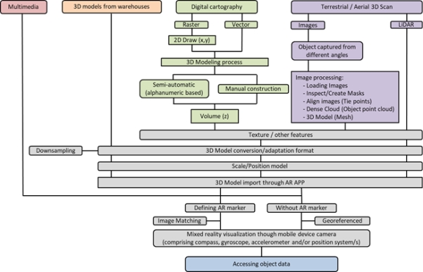
Figure 3 - Schematic approach to gather/model and
visualise 3D objects in an AR environment
Considering the fluxes of data, simple multimedia images/videos might
be visualised within mixed reality environments through mobile
platforms. In the case of built 3D models (e.g. internet catalogues), it
may be necessary to convert or adapt these to other formats, compatible
with the AR application to be used in the mobile device. Based on
digital cartography, in the case of the 2D vector, the volume associated
with alphanumerical “z” values can been created (beside the z value, in
the case of a building having, for example, the number of floors, the
user can assign a medium height and multiply to calculate an estimation
of the building’s volume), while on raster documents (e.g. satellite
imagery or ancient cartography) the process requires 2D/3D drawing and
eventually adding texture (e.g. building façades) or other features
(e.g. audio or video) (Marques et. al., 2016). A 3D scan can be made
using several techniques, geomatics, sensors and terrestrial or aerial
platforms, taking into consideration scale and object availability. The
UAV become extremely relevant considering fast data acquisition based on
low cost platforms (when compared with traditional methods).
Photogrammetric applications and point cloud extraction by
image-matching overlapped images generates rapid data acquisition and
processing results. LiDAR might be applied to collect three dimensional
point clouds of cities and buildings. High levels of detail and
considering large amounts of data retrieved in the models produced, it
is frequently necessary to convert, filter and down sample these to
further improve the performance of the model, especially in mobile
platforms (considering the graphics and processor capacity). The models
produced required some adjustments regarding graphic correction, scale
and positioning. Once the 3D model has been imported to the AR
application, a marker can be defined through image matching recognition
(e.g. satellite imagery, ancient map or a touristic map, as in
previously to examples) or visualised over a certain chosen surface.
However, in the case of not using AR markers, the visualisation in the
field may be associated with real coordinates (a georeferenced 3D model)
and eventually enable the possibility to access more information about
the object.
3. CASE STUDY: LISBON AQUEDUCT SYSTEM
3.1. Identifying the Lisbon Aqueduct System (LAS)
The “Águas Livres” Aqueduct System was projected as one of the
boldest hydraulic engineering structures built in Portugal,
crossing the municipalities of Loures, Sintra, Amadora, and Lisbon.
The works for the construction of this complex system were initiated in
the 18th century. Built in limestone, the Águas Livres Aqueduct System,
which has been deactivated for 50 years, is presently an important
historical and cultural heritage landmark in Lisbon. The Lisbon aqueduct
collected, transported, accumulated, and distributed water by gravity
(with a descent of ~3mm/m); it included the general aqueduct (14km), the
subsidiary extensions, reservoirs, underground galleries and fountains,
which in total extended for a length of approximately 58km. The aqueduct
was classified as a National Monument in 1910 and its most remarkable
section is located in the Alcântara Valley. The existence of this
structure in the city is not obvious, especially because it is not
visible (it is mostly underground), although it has contributed to
define in part the evolution of the territory (with regard to water
supply, but especially considering the impact of the implementation of
the aqueduct system).
The use of technology applied to cultural heritage has enormous
advantages to better visualise and understand the importance of such
elements, recognising the connection between the structural elements
(visible) and areas (known by its path). In view of the importance of
the Lisbon Aqueduct monument, research was undertaken for the
elaboration of a mobile device App (Android) that enables the
visualisation of the GIS information and 3D modelling in the AR
environment on site. The GIS data collected and project, consisted in
the georeferencing of several sets of ancient cartography
contemporaneous to the LAS (to identify and vectorise the entire system
and associated elements: Reservoirs, fountains, vents, etc.) and several
other datasets, (such as terrain, water lines, roads, building)
supported the system comprehension and identification. Example of that
is the Digital Terrain Model, which helped to better comprehend the
water distribution through gravity and the system galleries and
aqueducts. The identification of the Lisbon Aqueduct System structure
and associated elements within the GIS project, produced new
georeferenced datasets, consisting mainly in segments and dots (X, Y).
The several sets of ancient cartography used (from the years 1856, 1858,
1868, 1968), required procedural processes of scanning, colour and
geometry correction and built mosaics of parts of charts. The
cartography, during the procedure of georeferencing, reveal to be highly
accurate being extremely useful for the identification of much of the
path of the main aqueduct, adductors, distribution galleries and
associated elements, enabling the delimitation of traces on the
territory, as well as missing objects, displaced or projected but never
executed.
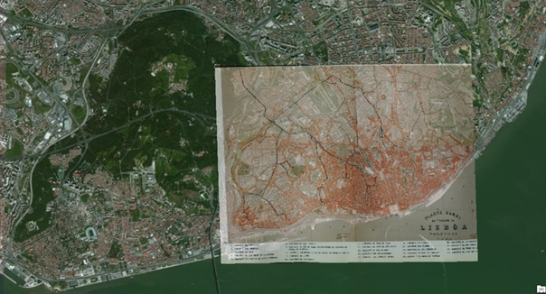
Figure 4 - Identification of the Lisbon Aqueduct
System using ancient cartography (Planta Geral da Cidade de Lisboa,
1868), GIS georeferencing (transparent) over satellite imagery
3.2. 3D Data Modelling
There are several internet catalogues and warehouses with 3D models
available to use. Besides that, the creation of 3D models could be
carried out with common software (e.g. 3D Studio Max, Blender, Sketchup,
or City Engine), with a high level of detail and without losing
performance while inserting them into the augmented reality application.
However, the use of a survey point cloud based on a collection of
fieldwork photographs proved to be surprising, taking into account its
rapid acquisition and processing capabilities with the additional
advantage of being authentic. The processing stages of the workflow,
besides being very organised and intuitive for the user, allow for the
adjustment of several specific tasks and adequate different types and
sources of data (multiple scales, objects, environments and/or using
different devices and techniques). The software generates 3D models
extremely quickly, with regard to the procedures of inserting and
aligning photos, and building dense clouds, meshes and textures (with a
wide variety of output formats), as refered already in the Figure 3,
image processing from terrestrial/aerial scan (Figure 5).
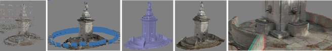
Figure 5 – 3D modelling process of the Armada
fountain (Tie points, Dense Cloud, Mesh, Texture, Anaglyph)
However, the technical challenge is to simplify these 3D models (with
the elimination of faces for example) without losing the realism of
urban elements. With the 3D modelling software (Agisoft Photoscan), it
is possible to draw masks in the pictures taken to reduce the area of
the image that the software has to process, identifying common pixels.
The position of the pictures (cameras) made by the software (alignment)
is commonly amazingly accurate and very near the reality. During the
modelling process, it is possible to eliminate data that could introduce
unnecessary noise to the final result. The parameters used depend on
computer capacity and final results objective, considering the limited
resources of the current most commonly used mobile devices. The Águas
Lives aqueduct system has several elements that permit the collection of
data by using simply terrestrial images (on site) and creating point
cloud meshes.
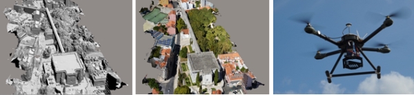
Figure 6 – 3D modelling using UAV collected data
for the “Mãe de Água” water reservoir
Otherwise, considering the dimension and volume of objects such as
“Mãe de Água das Amoreiras” (37x33m com 17m height building), it is very
difficult to conduct a survey without using high or aerial platforms.
After having all the authorisations and subsequently performing the
necessary flight tests and security, it was decided to use UAV to
collect data for the “Mãe de Água” water reservoir. Thus, the usage of a
UAV greatly simplifies the assignment of collecting data and processing
them, although these data are authentic with an impressive level of
detail.
In the technical-scientific field, there is a growing interest among
technicians for the usage of 3D virtual models, taking advantage of
their enormous potential for pedagogical, documentary, and exploratory
activities, as well as of their predictive power. This is especially
relevant for urban studies since it facilitates interventions in
historical sites, rehabilitation and planning of buildings,
neighbourhoods and cities, providing opportunities to simulate past,
present, or future interventions, and their respective evolution and
management, where people can move through and interact with the space
within a virtual/mixed environment. This emergent interest is associated
with the very fast process of urban sprawl, also tied with the tendency
of cities to growth in terms of height (Z axis) and consequently
elevating the level of complexity of the urban processes that take place
in the third dimension. Mixed Reality environments have the potential to
assist decisional processes in the context of urban and environmental
planning, cultural and natural heritage modelling, adding the capability
to increase (virtual or real) representational information to the
selected environment presented (also virtual or real). Realistic 3D
environments offer the user interesting possibilities of immersing
in/combining with the real world, e.g. convincing reconstructions of
events and contexts particularly to raise historical awareness. Virtual
environments and especially Augmented Reality have, thus, a clear
potential to support cultural heritage, highlighting and enriching its
value in a dynamically and interactive form. It also allows users,
especially the general public, to learn, intervene, and experience with
higher engagement innovative approaches to the promotion, operation, and
dissemination of cultural heritage.
3.3. Building a mobile App (Lx_W App)
The research about the development of one mobile App to visualise the
LAS within an Augmented Reality (AR) environment developed several tests
consisting in the use of the mobile device camera to visualise the
elements of the LAS in virtual data over the real environment. Using the
segments and dots of the structure collected previously was possible to
understand, in place, the location of the structure and the azimuth of
any other element of this monument and the respective distance (from the
place of the user and using the device position system – GNSS). However,
the most interesting capability revealed to be the possibility to enrich
a free and accessible city official plan in paper, with virtual sets of
2D/3D produced data within an AR environment. To accomplish that, it was
developed the mobile App Lx_W (Lisbon Water), which was divided in two
main Apps, consisting in the AR component: AqueductAR; and the LAS
contents: AqueductGPS (ancient and actual pictures, texts, possibility
to visit, costs of entrance, google map thematic representation,
proximity alert and navigation). The Lx_W App was developed having in
mind the idea of using the paper city plan (Official Lisbon Plan),
extremely accessible and available for free, as a AR marker (Marques et.
al., 2017). The combination between the paper maps (analogue) with the
digital virtual data at 3D/4D, superimposed within an Augmented Reality
environment is a very interesting capability that might be useful to
endless applications (for example, in this project, it was though to use
as case study the ancient Fernandina Wall or the Lisbon 3D recreation
before the 1755 Lisbon earthquake). The limited base information printed
in paper can in this way support innumerous datasets of geographical
information, transforming this simple paper map into any thematic
cartography required by the user and properly developed. This idea has
several exciting approaches while thinking in: the combined
intergenerational use (between the older people preferring the paper and
younger generation visualising the virtual data through the mobile
device); or the portable unfindable thematic proposes; higher number of
possibilities for visitors exploration (e.g. touristic/visitor paths
with monuments/restaurants/university campus highlighted in 3D
visualisation); new forms of sites and brands promotion or publicity;
support for navigation; alerting for proximity of objects; among others.
Superimposing the representation of the LAS structure over the Lisbon
Official Plan, the users are able to simply open the App, point the
camera to the paper city map and visualise the digital information
within an AR environment and then, interact with and access to more data
for each object (e.g. visualise ancient pictures of that object, read
the text about its engineer/architect, or identify their position on map
and the relation to the rest of the LAS structure).
Figure 7 – LAS structure 3D visualization within
an Augmented Reality environment through mobile platforms over a simple
paper city plan (accessible and available for free). Image from the
authors (Marques et. al., 2017)
The case study of LAS was preferred, considering the especial
feature that the remains of this important landmark are mostly
underground and are not known by visitors or even by some inner
residents. It is also relevant to verify that some parts of these
underground galleries can be visited, having an enormous potential for
tourism and consequently functioning as sources of income for its
management entities.
Nevertheless, the main research idea that outcomes from the
development of this App was to increase the intrinsic value of this
cultural heritage object; in this case, considering not only the
individual elements of the aqueduct, but also the wider delimitation of
the entire system (over years of constant construction), identifying the
most relevant path and associated elements, starting from several
springs, subsidiaries and distribution aqueducts and galleries, vents,
connections with the exterior and culminating in the fountains, spread
throughout some of the most relevant and growing locations within the
city (18th to 20th centuries). Most of these places are within the most
touristic and visited areas of Lisbon, which could not be detached from
cultural heritage knowledge and dissemination, considering the potential
interest of a tourist to discover the city.
4. FINAL REMARKS
The buildings with heritage value, as is the case of the Lisbon
Aqueduct System (Águas Livres), are part of the city as outstanding
elements of the urban space. Often, these elements are so iconic that
they form a relevant part of the city identification itself (as is the
case of the Colosseum in Rome, the Eiffel Tower in
Paris, the Cathedral of the Sagrada Familia in Barcelona, the
Tower Bridge in London, just to name a few examples). These
cultural heritage elements have a substantial power of attraction,
particularly for tourists. Tourists somehow endorse these “attractions”
since they are systematically preferred for their visits, as circular
causality. It is the unique value of this heritage with “global
influence” to shape the image of the cities.
Technology has always been at the service of promoting and enhancing
heritage. Photography, for example, is one of the technologies that has
most contributed to record what we might call “memory extension”, i.e.,
it has been used throughout the ages as a means to record moments of a
tourist visit, to remember later (this is what we refer to as “extension
of memory”); sharing with other the experience they have lived.
Augmented Reality is an enriched view of the physical world that
empowers users to experience virtual data superimposed on real
environments that function interactively in three or four dimensions
(3D+time) in real time. The emergence of mobile devices such as
smartphones anticipated a huge potential field request for Augmented
Reality applications. When appropriately conducted, the application of
three or four dimensional Digital Representations of Cultural Heritage
superimposed on the real world, within an Augmented Reality environment,
using mobile platforms has the power to improve temporal understanding,
map the uncertain, verify the limitations of human perceptual reasoning,
and create systems to form collaborative solutions, envisioning
processes, simulations, and results. These external affordances enhance
human cognition and help to understand societal and anthropologic
behaviour besides their symbolism, considering the bases of cultural and
heritage conceptions. This is highly relevant for human knowledge,
enhancing and augmenting the intrinsic value of the object in analysis.
The value attributed to Cultural Heritage might be increased by the use
of digital representations, which disclose, explain and promote its
symbolic significance, technical-scientific importance, unicity, or
other relevant assets, disclosing what could be considered as an
Augmented Valuation of Cultural Heritage.
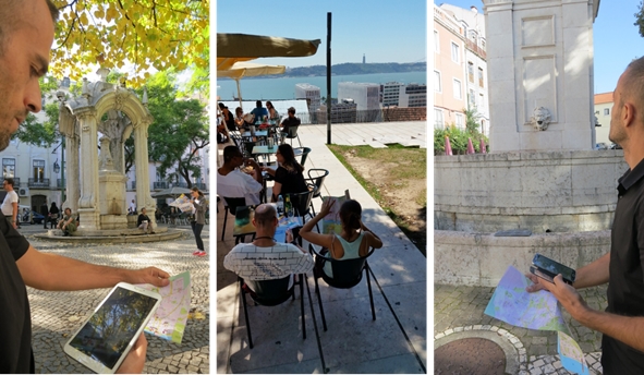
Figure 8 – Visualising the
LAS structure within a AR environment over the city official plan
The concept of Augmented Valuation of Cultural Heritage (Marques, 2017)
is clearly inspired by the concept of Augmented Reality, being capable
of identifying, analysing, and increasing/augmenting the intrinsic value
that is already present in the notion of cultural heritage. This concept
brings about the opportunity to recognize that, besides the idea of
enriching the physical environment with virtual synthetized data,
Augmented Reality technology can simultaneously increase the intrinsic
value of cultural heritage. This concept presupposes the process of
augmenting the value of cultural heritage. This valuation is dynamic
since the user experience mixed reality environments as the process of
dynamically augmenting cultural heritage valuation.
ACKNOWLEDGEMENT
We would like to express our deepest gratitude to: Teresa Romão,
Fernando Birra and Antero Pires from the NOVA Laboratory for Computer
Science and Informatics (NOVA LINCS), unit of the national Science &
Technology network in the area of Computer Science and Engineering,
hosted at the Departamento de Informática of Faculdade de Ciências e
Tecnologia of Universidade NOVA de Lisboa – Portugal (DI-NOVA), for
the conception and implementation of the App. To the startup company
GEODRONE and its founder João Marques for the UAV survey. To Josep Roca
from UPC – BarcelonaTECH and CPSV for suggestions and critics.
REFERENCES
MARQUES, L., 2017. Augmented Valuation of Cultural Heritage
Representations based upon Geographic Information Technologies: the case
study of Lisbon Aqueduct System within an Augmented Reality environment. PhD
Thesis. Departament de Tecnologia de l'Arquitectura, Universitat
Politècnica de Catalunya, Barcelona, Spain.
http://upcommons.upc.edu/handle/2117/111501
MARQUES, L.; CLADERA, J. R., TENEDÓRIO, J. A., 2017. Valorisation
of urban elements through 3D models generated from image matching point
clouds and augmented reality visualization based in mobile platforms,
Proc. SPIE 10431, Remote Sensing Technologies and Applications in
Urban Environments II, 104310P (4 October 2017); doi:
10.1117/12.2278065.
http://dx.doi.org/10.1117/12.2278065
MARQUES, L.; TENEDÓRIO, J. A., BURNS, M. C., ROMÃO, T.; BIRRA, F.;
MARQUES, J.; PIRES, A. 2016. Cultural Heritage 3d Modelling and
Visualisation Within an Augmented Reality Environment, Based on
Geographic Information Technologies and Mobile Platforms in ACE
Arquitectura, Ciudad y Entorno.
http://upcommons.upc.edu/handle/2117/101733
TENEDÓRIO, J. A., REBELO, C., ESTANQUEIRO, R., HENRIQUES, C. D.,
MARQUES, L., & GONÇALVES, J. A. 2016. New Developments in
Geographical Information Technology for Urban and Spatial Planning. In
I. Management Association (Ed.), Geospatial Research: Concepts,
Methodologies, Tools, and Applications (pp. 1965-1997). Hershey,
PA: IGI Global. doi:10.4018/978-1-4666-9845-1.ch094.
https://www.igi-global.com/chapter/new-developments-in-geographical-information-technology-for-urban-and-spatial-planning/149585
PINTO, N.N.; TENEDÓRIO, J.A.; ANTUNES, A.P.; ROCA, J., Eds. 2014.
Technologies in Urban and Spatial Planning: Virtual Cities and
Territories. Hershey/Pennsylvania, IGI Global, pp. 342. DOI:
10.4018/978-1-4666-4349-9
https://www.igi-global.com/book/technologies-urban-spatial-planning/75471
RATTI, Carlo (2014). The "Sensing" City Is the Future of
Urbanism:
http://www.metropolismag.com/cities/the-sensing-city-is-the-future-of-urbanism/
Yin, L. 2010. Integrating 3D Visualization and GIS in Planning
Education. Journal of Geography in Higher Education, 34(3),
419–438.
https://doi.org/10.1080/03098260903556030
BIOGRAPHICAL NOTES
José António TENEDÓRIO
Geographer, Associate Professor at Universidade NOVA de Lisboa (UNL),
Faculty of Social Sciences and Humanities (FCSH) and Researcher at
CICS.NOVA - Interdisciplinary Centre of Social Sciences, RG4, Lisbon,
Portugal. He is a Visiting Professor at Polytechnic University of
Catalonia, BarcelonaTech (UPC), Faculty of Architecture, CPSV, Spain. He
was Director of Centre for Geographical and Regional Planning Studies
(e-GEO, FCSH, UNL), between 2003 and 2008, member of the Executive
Committee of the Department of Geography and Regional Planning of
FCSH-UNL (2008-2013), Director of M.Sc. in Territorial Management at
UNL-FCSH (2008-2013) and Director of M.Sc. in Spatial Planning & GIS
(e-Learning) at UNL-FCSH (2010-2013). Graduated in Geography and
Regional Planning (1984) at UNL-FCSH. He attended Sorbonne-Universités,
University of Paris VI-Pierre et Marie Curie, Faculty of Sciences, where
he post-graduate (DESS in 1991) in Remote Sensing and the University of
Paris XII, Urbanism Institute, to obtained Ph.D. (1998) in Urbanism. His
main scientific area of research is Remote Sensing, GIS, Spatial
Analysis, and Geographical Modeling. He has published more than one
hundred papers (book chapters, papers in periodic with scientific
refereeing, papers in conference proceedings with scientific
refereeing). In 2013 he received the (first prize) SANTANDER Award for
the Internationalization of the FCSH Scientific Production 2013. In
2015, for the second time, he received the (first prize) SANTANDER Award
for the Internationalization of the FCSH Scientific Production 2015 (ex
aequo).
Luís Filipe MARQUES
PhD (2017) in Urban and Architectonic Management and Valuations at
Barcelona School of Architecture of the Polytechnic University of
Catalonia – BarcelonaTech (ETSAB/UPC). Master (pre-Bologna, 2010) and
Post-Graduate (pre-Bologna, 2002) in “Land Use Management and
Environmental Planning” at the Faculty of Science and Technology of the
New University of Lisbon (FCT/UNL), Portugal. Degree (pre-Bologna – four
years) in Geography and Regional Planning at the Faculty of Human and
Social Sciences of the New University of Lisbon (FCSH/UNL), Portugal
(1997-2001). Senior technician at IGAMAOT – General Inspection for
Agriculture, Sea, Environment and Spatial Planning (Portugal). Has been
collaborating with several organizations of the public administration
(at central, regional and local level) and private companies, mainly in
research projects related to the themes of spatial planning and
environment (commonly with the use of Geographic Information
Technologies).