Land consolidation, customary lands, and
Ghana’s Northern Savannah Ecological Zone: An evaluation of the
possibilities and pitfalls
Zaid ABUBAKARI, Netherlands, Paul VAN DER MOLEN,
Netherlands, Rohan M. BENNETT, Netherlands, Elias DANYI KUUSAANA, Ghana

 
Zaid ABUBAKARI Elias DANYI
KUUSAANA Rohan M. BENNETT
1)
This paper was presented at the International Symposium on Land
Consolidation and Land Readjustment – held in Apeldoorn, The
Netherlands, 9 – 11 November 2016. The paper demonstrates that Land
Consolidation - as an existing and proven approach - can be used very
well for future challenges - as mitigation of and adaptation to climate
change effects.
SUMMARY
Land fragmentation has been identified to greatly undermine crop
production in many countries. In the case of Ghana’s customary tenure
system, household farmlands are relatively small and are highly
fragmented. Recent agricultural drives, however, have focused on farm
level interventions that are ad hoc with short-term benefits. A
sustainable long-term application of land consolidation which
reorganizes farmlands may improve yields, reduce the cost of production
and improve the incomes of farmers. The successful implementation of
land consolidation depends greatly on the suitability of local
conditions with respect to land tenure and land use. However, in Ghana’s
customary lands, the alignment between the requirements for land
consolidation and existing conditions remains unexplored. This study
investigated the feasibility of land consolidation within the customary
tenure by juxtaposing the local conditions of the study areas with the
baseline conditions for land consolidation outlined in literature. Using
both qualitative and spatial data, the study revealed some traits of
convergence and divergence with respect to the baseline conditions in
the study areas. For example, conditions such as the existence of land
fragmentation, suitable topography and soil distribution were fully met.
Conditions such as the existence of a land bank, technical expertise,
and infrastructure and supportive legal frameworks were partially met.
The remaining conditions such as the willingness to participate,
availability of a land information system and favorable land ownership
structure were non-existent. The circumstances surrounding these unmet
conditions are deeply embedded in customs and traditions that hardly
yield to change. Since these conditions are fundamental for land
consolidation, their absence negates the feasibility of land
consolidation under the current tenure system of the study areas.
1. INTRODUCTION
Agricultural productivity depends on a number of factors which vary
in extent across the globe. These include climatic conditions, level of
technological advancement, farming practices and government policies –
including those related to land tenure systems. With respect to the
latter, a land tenure system might promote land fragmentation, which is
known to undermine agricultural productivity (Demetriou et al., 2013b).
Land fragmentation creates disjointed and small farmlands, thus acting
as a disincentive and a hindrance to the development of agriculture
(Manjunatha, Anik, Speelman, & Nuppenau, 2013). This viewpoint is
however debated: (Blarel, et al. 1992) argues in favour of land
fragmentation describing it as a way of reducing risk and easing
seasonal bottlenecks. In Ghana, it is estimated that about 90% of
farming households operate on less than 2 hectares (MoFA-SRID, 2011):
these farmers keep multiple farmlands for the production of a variety of
crops. Land is predominantly owned and controlled by customary
institutions including chiefdoms, families and Tendaamba (Arko-Adjei,
2011). The control and ownership exercised by these institutions is
built on the concept of collective ownership of land which gives every
member the right to use a portion of the communal land. It is generally
believed that an increase in the number of owners creates land
fragmentation (Farley et al., 2012). Asiama (2002) shares the view that
customary tenure arrangements provide members with equal interests in
land which leads to fragmentation of farmlands as they try to allocate
land for the use of every member. Fragmentation is also linked to
inheritance(Demetriou et al., 2013b; Niroula and Thapa, 2005) as the
continual intergenerational devolution of land from parents to children
increases ownership creates common property which lead to both ownership
and use fragmentation.
For cases like Ghana, if farmland fragmentation is accepted as a
problem, responses will likely depend on innovative approaches such as
land consolidation. Land consolidation is the process of re-allocating
rural land that are considered fragmented (Vitikainen, 2004). It is also
seen as a tool for enhancing agriculture and assisting rural development
(Sklenicka, 2006; Thomas, 2006). The concept of land consolidation has a
history dating back to the Medieval Ages in Europe. The current form of
land consolidation practices have evolved in Europe towards the end of
the 19th Century to the beginning of the 20th Century (Vitikainen,
2004). The concept developed and became multidimensional incorporating
emerging issues like environmental management, development of rural
areas (Zhang et al., 2014) and improvement of appropriate infrastructure
(Vitikainen, 2004). Lemmen et al. (2012) indicated that, the initial
mono-functionality of land consolidation was to increase agricultural
production through parcel enhancement; reduction of production cost and
increase in farm efficiency.
Current interventions in the Ghana agricultural sector including the
Food and Agriculture Sector Development Policy (FASDEP I & II) and
strategies like the Growth and Poverty reduction Strategy (GPRS I & II)
provide seemingly good objectives including the improvement of food
security, enhancement of farmers’ income, application of science and
technology, sustainable management of land, and improvement of
institutional coordination (MoFA-SRID, 2011). However, the
implementation of these objectives focus on subsidies and credit access
programmes which are mostly supported by international donor agencies,
and they subsist as long there is continues support. Over the years, the
attention has therefore always been on short to medium term programmes,
with little or no attention on the sustainable application of long-term
strategies such as land consolidation. Land consolidation is
self-supporting and appears more sustainable and does not require
continuous support from either government or donor agencies.
Experiences with land consolidation in countries like the
Netherlands, Germany and Denmark have demonstrated good results for
agricultural output. In these countries private property rights and
state ownership are dominant, however, scientific research is lacking on
the use of land consolidation within the customary tenure environment
where there is communal ownership of land. Ghana, a country dominated by
customary tenure, has not tested land consolidation as an option for
enhancing agricultural development. Having regard to the complexities of
customary tenure such as oral allocation, indeterminate boundaries and
emotional attachment to land, it is unclear if land consolidation will
be feasible. This premise underlies the overarching objective of this
paper: to investigate the feasibility of land consolidation in the
customary areas of the Northern Savannah Ecological Zone (NSEZ) of
Ghana. Specifically, the study enumerates the baseline conditions
required for conventional land consolidation, examines the existing
tenure and land use situation, and compares the baseline conditions to
the context of the study areas. The paper first provides a background on
customary tenure systems in northern Ghana, land fragmentation and the
consolidation nexus. Subsequently, the study methodology, discussion of
results, conclusion, and policy recommendations.
2. CUSTOMARY LAND TENURE SYSTEMS IN GHANA
The concept of customary tenure is multi-dimensional and has been
used synonymously in different contexts with the terms ‘indigenous
tenure’, ‘traditional tenure’ and ‘communal tenure’ by various
researchers (Arko-Adjei, 2011). USAID (2012) describes customary tenure
as the embodiment of rules that govern the access, use and disposition
of land and its resources within a community. Under customary tenure,
land is sometimes seen as a spiritual entity recognised as a divine
heritage in which the spirits of the ancestors are preserved (Asiama,
2002). Elias (1956) viewed land in the customary context as an age-long
entity that connects the past, present and future members of a
community.
In Ghana, customary ownership accounts for about 80% of the total
land (Kasanga & Kotey, 2001). Families and communities (through
stools/skins1), own these lands. Although differences exist amongst
various ethnicities, there is enough commonality to enable a
categorisation of the Ghanaian customary tenure systems into two broad
groups. The first category is land owned by communities that exist as
chiefdoms. In this category there is a centralised political structure
composed of a hierarchy of chiefs headed by a king. The hierarchy
devolves from the king to paramount chiefs, divisional chiefs and
caretaker chiefs (Arko-Adjei, 2011). Under chiefdoms, each hierarchy of
authority has an overriding power over all the smaller chiefs below it.
The second category is land owned by families where the Tendaamba play
an eminent role in the ownership of land and alienation. Family lands
are controlled by family heads, usually the father in a nuclear family
and the oldest elder in an extended family (Godwin & Kyeretwie, 2010).
1 The use of the terms stool and skin represents the symbols of
authority of chiefs in Ghana. Whilst the stool is the symbol of
authority for chiefs in the southern part of Ghana, the skin (of an
animal) is the symbol of authority for chiefs in the northern part.
There is often the tendency in Ghana to refer to the chieftaincy of a
particular area as the stool or skin. There are even verbal forms
created: to enskin, to enstool; and derived nouns: enskinment and
enstoolment.
3. LAND FRAGMENTATION AND LAND CONSOLIDATION NEXUSES
Land fragmentation is defined as the division of single farmlands
into spatially distinct units (Binns, 1950; McPherson, 1982). King and
Burten (1982a) described the manifestation of land fragmentation in two
forms. First, the division of farmlands into units too small for
profitable exploitation, and secondly, the spatial separation of
farmlands belonging to a single farmer/household. Demetriou (2014)
describes land fragmentation as a spatial problem concerned with
farmlands, which are organised poorly in space with reference to their
shape, size and distribution. Van Dijk (2004) categorised land
fragmentation in terms of ownership and land use. Land fragmentation may
be caused by a number of factors, such as population growth and
inheritance (Binns, 1950; McPherson, 1982; Niroula and Thapa, 2005).
The relationship between land fragmentation and agricultural
productivity is opened to debate. Some researchers including Blarel et
al. (1992) argued in their study in Ghana and Rwanda that fragmentation
of farmland is not as inefficient as generally perceived. They supported
this view by arguing in favour of fragmentation as a tool for the
management of risk, seasonal bottlenecks and food insecurity. This view
is also shared by FAO (2012) who advocated for the maintenance of
fragmented farmlands if they result in productive benefits. Monchuk et
al., (2010) in a study in India concluded that the adverse economic
impacts of land fragmentation are somewhat small but provide room for
adaptation for a variety of circumstances. Contrary to this opinion,
(Niroula and Thapa, 2005) viewed land fragmentation as a mark of farm
inefficiency pointing to its ripple effects on distance, size and shape
of farmlands. Manjunatha et al. (2013) explains that land fragmentation
deprives farmers of the benefits of economies of scale. Demetriou et
al., (2013a) also noted that fragmentation is a disincentive to
mechanised large-scale agriculture. In line with this second debate,
land consolidation has been promoted as a long-term strategy to manage
land fragmentation and promote land use efficiency.
Land consolidation is the procedure of re-allocating a rural area
consisting of fragmented agricultural or forest holdings or their parts
(Vitikainen, 2004). It is a tool for improving land cultivation and
assisting rural development (Sklenicka, 2006). The common principle that
underlie most land consolidation projects is the reconstruction of
fragmented and disorganised landholdings (Thapa and Niroula, 2008).
3.1 Baseline conditions required for land consolidation
Certain conditions are required as input for the implementation of
land consolidation. There exist variations as to what these conditions
are and their difference depends on the particular type of land
consolidation, the objective of implementation and the geographical
context within which it is implemented (Vitikainen, 2004). Conditional
requirements that underpin land consolidation are generally similar but
may be fine-tuned to enable tailor-made packages that meet the needs of
society (Van Dijk, 2007). Contrary to earlier research works of Bullard
(2007) and Vitikainen (2004) which focused more on formal legal
framework, Lisec et al. (2014) argued that the conditions for the
implementation of land consolidation should be reflective of both the
formal and informal institutional framework. For land consolidation to
be implemented, land fragmentation of some sort should have been
established within the geographic area in question (FAO, 2012). Some
researchers have pointed to land fragmentation in a number of ways as a
fundamental factor that calls for land consolidation (Bullard, 2007;
Demetriou, 2014; Long, 2014; Van Dijk, 2007). In the design of land
consolidation for central and eastern European countries, FAO (2003)
enumerated some of the conditions for land consolidation to include;
enabling legislation, land information system, land bank, willingness of
participants to consolidate and technical know-how. Other researchers
such as Jansen et al. (2010) categorised the requirements for land
consolidation broadly into legal and institutional requirements.
Land consolidation in many countries is regulated by legislation(s)
(Vitikainen, 2004). The need for the development of land consolidation
regulations was occasioned in the past when it became apparent that
fragmented lands could not be consolidation based on the operations of
the free land market (Van der Molen and Lemmen, 2004). Legislation is
not only meant to address land fragmentation, but also to prevent the
reoccurrence of fragmentation in the future (Bullard, 2007). Most
importantly, the interference with private property rights during land
consolidation requires a legitimate legal backing so as to protect the
rights of landowners and land users. In view of this, land consolidation
legislation amongst other things defines the limit and manner to which
private property rights may be interfered, the category of right holders
that are recognised and can participate in land consolidation (Hong and
Needham, 2007).
Van Dijk (2007) observed that success in land consolidation depends
on the willingness of landowners and land users to participate in the
process. This is especially the case, where there is no element of
compulsion in participation (Louwsma et al., 2014). FAO (2003) indicated
that the willingness of land owners sometimes depend on the proposed
benefits and the terms of cost sharing between central government
agencies, local government, land owners and users.
When stakeholders are willing to participate in land consolidation it
then becomes necessary have to a reliable land information system
(Demetriou et al., 2013a) which provides an inventory of land
ownership/use rights and also acts as a platform for verifying claims
(Sonnenberg, 2002). The reallocation of lands which involves the
exchange, distribution and portioning of land requires detailed land
information that provides ownership rights, property boundary
information, digital topographic data as well as proposed developments
in the project area (Bullard, 2007). As discussed earlier, land
consolidation in recent times, for most parts of the developed world,
incorporates adjoining public works such as construction of roads,
drainage systems and irrigation facilities which makes it even more
relevant to have a sufficient land information system (Demetriou et al.,
2013a).
Another condition for land consolidation is the existence of a land
bank. Damen (2004) sees land banking as the bedrock for successful land
consolidation. Damen described land banking as a means of acquiring and
managing land in rural areas by state organisations for the purpose of
redistribution/leasing with the aim of improving agriculture or in the
general interest of the public. Land banks provide an opportunity for
expansion, shaping of farmlands, and creation of adjoining
infrastructure (Van Dijk, 2007). Land bank increases land mobility and
creates room for a flexible land consolidation design and reallocation
process (Hartvigsen, 2014).
Being a surface activity, land consolidation is affected by
geographical conditions such as topography, soil and water distribution.
Differences in topography and quality of soil affects land reallocation
which is the core of land consolidation (Lemmen et al., 2012;
Sonnenberg, 2002). In hilly and mountainous areas there exist sharp
variations in surface characteristics and creation of regular shapes for
farmlands may be interrupted by natural physical characteristics of the
terrain like hill tops or cliff faces (Demetriou et al., 2012). This is
further supported by Sklenicka (2006) who sees sharp topographic
differences as one of the factors that hinders land consolidation.
Likewise, substantial soil quality heterogeneity inhibits reallocation
of lands compared to a fairly homogenous distribution of soil quality.
The nature of rights, use and ownership of land affects land
reallocation. Modern land consolidation results in change of ownership
rights and registration of new titles in the land register (Lemmen et
al., 2012). The ability of a private landowner to choose to participate
in land reallocation without any ownership constraints is therefore
important. Thus, dual and multiple ownership either at the family or
community level restricts unilateral decision making. This may hinder
the decision of members in exchanging land during reallocation
(Demetriou et al., 2012). Also, implementing land consolidation requires
some technical capacity and infrastructure. It is difficult to wholly
import and implement land consolidation based on the framework of other
countries that have succeeded in its implementation (Thomas, 2006). It
is necessary for countries, which have not yet implemented land
consolidation to adopt and modify the existing examples to meet their
local needs (Van Dijk, 2007). This can only be done based on expert
technical knowledge. Thus, land use planners, land surveyors, estate
valuation surveyors, land administrators, agricultural engineers and
environmentalist are needed for the preparation and execution of the
land consolidation. Based on the knowledge of the local legal framework,
land market conditions and land tenure, experts are can develop a land
consolidation that efficiently meets local needs. Table 1 summarises the
main baseline conditions.
Table 1: Summary of baseline conditions for land consolidation
| Baseline Factor |
Remark |
| Existence of land fragmentation
|
Land consolidation is the cure for land fragmentation. Where there is no
land fragmentation at all, land consolidation may not be useful. |
| Willingness to participate
|
Willingness to participate in land consolidation implies stakeholder
acceptability and consent. Even without unanimous willingness, some
level of it is required for a successful land consolidation. In some
countries compulsion is used to attain full participation. |
| Availability of land information system
|
Land consolidation requires reliable inventory of ownership rights and
boundary information for its implementation. This enhances
re-allocation; which is the core of land consolidation and dispute
curtailment.
Existence of land bank |
| Existence of land bank |
Land banks provide additional land for uneconomic holdings,
infrastructure and as a substitute stock for unwilling participants
|
| Existence of legal framework |
This enables the protection of private property rights by defining the
limits and manner to which such rights can be interfered. |
| Suitable topography and soil distribution |
Uniformity in surface characteristics of land aids land consolidation as
it affords a fair platform for the exchange of farmlands. |
| Technical Expertise and
infrastructure |
To engender fit-for-purpose land
consolidation technical expertise in local land tenure and land
management dynamics and good infrastructure are essential for
success in land consolidation. |
4. METHODOLOGY AND DATA COLLECTION
This study was conducted in the Northern Savannah Ecological Zone of
Ghana. Specifically, the Upper West and Northern regions were selected.
This was necessary to represent the two forms of customary land
classification according to Godwin & Kyeretwie (2010). In the Upper West
Region of Ghana, the customary institution was originally built around
the earth priests (Tendaamba) who were literally the owners of the land.
In the case of the Northern region, the customary institution is
organised in chiefdoms headed by kings who manage the land on behalf of
the people. Authority over land devolves from the king through paramount
chiefs to divisional chiefs and caretaker chiefs. Chiefs have the
highest control over land and the level of control exercisable depends
on a chief’s position along the hierarchy. Therefore, to make the study
representative of the customary tenure systems in northern Ghana, two
farming communities were considered; Yaruu, in the Wa Municipality of
the Upper West region, and Tindan in the Savelugu-Nanton district of the
Northern region. These communities were selected because they are
typical farming communities with no formalisation of land rights, no
land commodification, and land uses are dominated by agriculture.
The sample frame for this study comprised 30 farmers with multiple
farmlands from the study areas and 2 customary institutional heads
(Tendaamba and Chief). The institutional heads were purposively sampled
and they assisted in accessing farmers. Primary data was collected
through interviews, focus group discussions and direct observation. This
was supported by multiple sourced secondary data to enrich the
discussions in this paper. The studied farmers were interviewed
regarding the number of farmlands, reasons for the choice of farm
locations, the reasons for having multiple spatially separated
farmlands, the environmental factors that affect the choice of land for
farming and willingness to exchange farmlands. The Tendaana and chief
were interviewed using open-ended questions to examine the land
ownership structure and also their role in and processes of land
allocation. Interviews were conducted with respondents at their homes
and on their farms. Two separate focus group discussions were held in
the two study areas. The focus discussions comprised farmers, chief and
Tendaamba. The focus discussions provided a wider understanding of
complex issues and circumstances that could not be collected from
individual interview sessions. They also provided an opportunity for
participants to express their views and discuss multiple views with
other participants, which gave a clear understanding of the interwoven
dynamics of land ownership and land allocation. For each respondent, we
visited their farmlands and collected data on their locations and
characteristics. The process was made more participatory and interactive
through the use of geo-referenced satellite images downloaded from
Google Earth and geo-referenced using Elshayal Smart GIS software. Soft
copies of the maps were loaded onto a mobile device equipped with a
global positioning system (GPS), which was used to record the geographic
positions of farmlands.
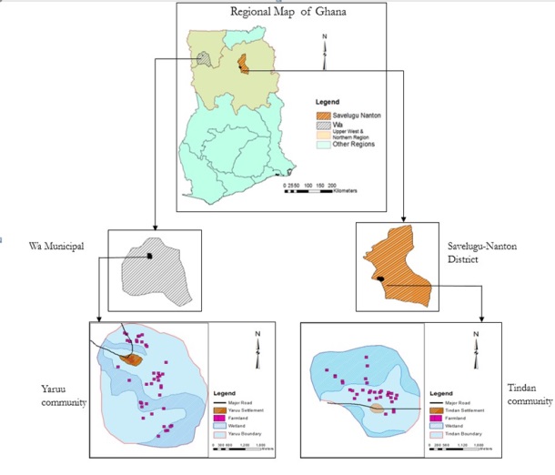
Figure 1: Map of the Study Areas
5. OPPORTUNITIES FOR LAND CONSOLIDATION
5.1 The existence of land fragmentation
Literature highlights land fragmentation as the basis for undertaking
land consolidation especially when it reduces agricultural productivity
(FAO, 2003). The results obtained from this study confirmed the
existence of land fragmentation in terms of land ownership and use in
both study areas. This deduction has been drawn through the
juxtaposition of the findings on household size, farmland size as well
as the number of farmlands per household. On the average, a household
owns three (3) separate farmlands in both study areas. Meanwhile, the
total size of land operated per household ranges from 1- 20 acres
resulting in a size of approximately 1-6acres per farmland, which is an
indication of fragmentation in terms of size. Also, considering the
spatial distribution of discrete farmlands, the average distance between
farmlands of the same owner is approximately 1600m in the case of Yaruu
and approximately 600m in the case of Tindan. Comparing this level of
dispersion to the small size of farmlands gives an idea that farmlands
are somewhat scattered. Similar to the findings of Thapa & Niroula
(2008) in the mountains of Nepal, the study areas exhibited the
tendencies of further fragmentation through the continual inheritance of
farmlands. Considering the household sizes, which range from 3 to 36
persons, it can be reasoned that fragmentation of ownership is inherent
since all male household members have the right of succession. This is
further supported by the fact that most farmers rely on inherence as the
main source of land acquisition. On the contrary, Blarel et al. (1992)
identified farmland fragmentation as a tool for managing seasonal
bottlenecks and food insecurity. In this study, it was revealed that 67%
of the respondents keep multiple farms because of crop diversity and
seasonal risk management. However, 93% of the respondents acknowledged
the problems faced with the operation of fragmented farmlands to
include; the inability to supervise all farms at the same time,
increased travel time and cost and this goes in line with the argument
of Bentley (1987) and Niroula & Thapa (2005). From the foregoing
discussion, it is established that there exist farmland fragmentation,
and this may increase significantly in future.
5.2 Willingness to participate
The success of land consolidation relies on land reallocation which
involves the exchange, portioning and redistribution of farmlands (Van
Dijk, 2007). This interferes with private property rights, and therefore
requires the willingness of landowners and land users to enhance
implementation. In some countries, legislation provides compulsion in
terms of participation since it is difficult to gain full voluntary
agreement. Sometimes voting is conducted in order to determine the level
of willingness of a people when implementing land consolidation. In the
case of Denmark two-thirds majority vote of landowners was solicited for
the execution of land consolidation, while the rest were compelled to
participate. In other countries like Norway, the decision to consolidate
is made by a land consolidation court (Sky, 2002). However, in the study
areas in northern Ghana, consensus is reached through majority community
acceptance and lobbying of opposition groups.
Although Lerman & Cimpoies (2006) identified the success of land
consolidation to be dependent on the willingness of landowners to
exchange farmlands, this study revealed otherwise. Only 40% of the
respondents are willing to exchange farmlands, while 60% of them are
unwilling. Within those who are willing to participate in exchange, only
3 out of a total of 13 are interested in permanent exchange, the rest
are only interested in a short term exchange. In respect of the study
areas, the question arose whether short-term exchanges fit the purpose
of land consolidation? Short-term exchanges undermine the purpose of
land consolidation in northern Ghana in line with the work of Jie-yong,
Yu-fu, & Yan-sui (2012), who emphasize active willingness as key for the
success of land consolidation. From the study, only 10% of the
respondents effectively supported land consolidation through their
willingness to engage in long-term/permanent exchanges. Contrary to this
pattern of response, 93% of the respondents studied are willing to have
their farmlands consolidated if it promises economic benefits.
Reconciling these contrasting responses creates a dilemma. On one hand
farmers are unwilling to exchange their land because of social reasons,
and on the other hand they desire economic gains. Can there ever be a
compromise between these extremes? From the economic point of view, this
situation can be changed if some agricultural infrastructure is provided
and farmers are afforded the opportunity to use single contiguous
farmlands for multiple crops. However, from the social point of view,
strong emotional attachments to land are hard to break. As noted by
Arko-Adjei (2011), the bond between people and land under customary
tenure is only broken under land commercialisation and urbanisation.
Therefore, under the current social climate and remoteness of these
communities, emotional attachment cannot easily be discounted. However,
in the long term the bond may weaken as the communities develop, and
open up opportunities for land commodification. Short-term exchange of
farmlands is inconsistent with modern land consolidation as it will
contradict with permanent change of ownership rights in the land
register (Lemmen et al., 2012).
5.3 Availability of land information system
To successfully undertake land consolidation, there is the need to
have a detail inventory of land ownership, use rights and boundary
information. This provides the basis for verifying ownership claims,
reallocation and settling boundary disagreements. From both study areas,
such land information was non-existent. Land allocation is done with no
written record on ownership, use and boundaries. Boundaries are mostly
demarcated using natural objects. In view of this systemic lapse of land
administration in the area, it may only support private land
consolidation in which participants may exchange lands within their own
agreed terms and criteria. However, comprehensive, simplified and
voluntary land consolidation cannot be done without sufficient land
information. The absence of recorded land information may also call for
the creation of project based land information, however, this is
difficult and time consuming, yet its correctness may not be guaranteed
(Sonnenberg, 2002).
5.4 Existence of a land bank
A land bank creates the opportunity for the expansion of farmlands
and improves adjoining agricultural infrastructure (Damen, 2004).
Assessing land banking from the study areas reveals unique traits. Kotey
(1995) indicated that, allodial title of ownership in chiefdoms resides
in the chief while the subjects have usufructuary interest. This
description fits the Tindan community, which is under the Dagbon
chiefdom. The land belongs to the entire community, while the chief acts
as a trustee. In such a case, all unallocated land within the community
belongs to everybody and is indirectly a land bank that can be used for
farmland expansion and infrastructure creation. Conversely, in the case
of the Yaruu community, all unallocated land is the property of the
Tendaamba. Hence, unallocated land in this situation cannot be
classified as a land bank since it is a private property and entry into
it will constitute trespass. Essentially, the Tendaamba are regarded as
one of the many owners of land though their ownership is the biggest.
Neither the Tendaamba nor individual families have overriding powers
over one another.
5.5 Existence of Legal framework
Legislation as a condition for land consolidation in the context of
the study areas is viewed from the national level since there are no
written laws at the community level, except the norms and customs of the
community. There are no laws on land consolidation in Ghana, and this
form of land reform has never been implemented. However, there exist
pieces of legislations that can be interpreted together to provide the
basis for its implementation. These legislations include the State Lands
Act 1962 (Act 125), which provides regulations for the expropriation of
private property by government; the Administration of Lands Act 1962
(Act 123), which deals with the management and disposition of customary
land and its revenues; the Ghana Highway Act 1997 (Act 540) which
provides regulations for private property interferences in respect of
road construction and the Lands (Statutory Wayleaves) Act 1963 (Act
186), which provides regulations for private property interferences in
respect of public installations and utility works. These pieces of
legislation may serve as the legal basis for the implementation of land
consolidation in the interim, but the extent to which they can
adequately support land consolidation is uncertain. Bearing in mind that
they are not tailor-made for land consolidation, there is a likelihood
of redundancy and inefficiency. These inefficiencies can impede the
realisation of land consolidation. Contrary to having a multiplicity of
legislation, a tailor-made legislation synchronises all the roles of
institutions and stakeholders in an efficient manner. From this point of
view, it can be reasoned that these different legislations may not
provide a solid base for the implementation of land consolidation.
5.6 Suitable topography and soil distribution
Land consolidation is affected by topography and soil quality. Sharp
changes in topography and high level soil heterogeneity limits the land
reallocation process during land consolidation (Lemmen et al., 2012;
Sonnenberg, 2002). The findings indicate that there exist favourable
geographic characteristics. Topographies of both study areas are fairly
flat with a height distribution of 100 - 150 and 300 – 350 meters above
sea level in the Yaruu and Tindan communities respectively. Height
difference in both areas is relatively gentle and is about 50 meters.
Soil on the hand is fairly homogenous and mainly composes of vertisols
and planosols in the Yaruu and Tindan areas respectively. Where there
exist differences in the natural attributes of lands, valuation is used
as a platform for comparison and possible exchange (Sonnenberg, 2002).
It might be based on market valuation (FAO, 2003) or natural yield
potential (Van Dijk, 2003). With respect to the study areas, it stands
to reason that the use of yield potential of soil is most suitable
bearing in mind that, there is no land market in these areas and
agriculture remains the dominant land use.
5.7 Technical expertise and infrastructure
A combination of technical expertise and infrastructure is required
to successfully commence and implement land consolidation. Right from
the conception of the decision to consolidate fragmented farmlands,
expert knowledge in the fields of planning, land surveying, land
administration, financing, engineering and project management is
required for preparatory works and actual execution (Van Dijk, 2007).
Findings from both study areas revealed that local technical expertise
at the community level was lacking. However, human resource is available
and could be harnessed from state institutions which are in charge of
land management, planning and agricultural development. These
institutions include the Land Commission, Town and Country Planning and
the Ministry of Agriculture (MoFA). Experts from these institutions
could be used in the execution of land consolidation in these customary
areas.
6. Conclusion and policy recommendations
In all, the study found out that some of the conditions for land
consolidation were met in a supportive manner. Those conditions, which
were not met, are considered fundamental for land consolidation. The low
level of willingness, absence of a land information system and
unfavourable ownership structure make bleak any opportunity of
implementing land consolidation. Against this background, land
consolidation in its theoretical sense is not feasible in northern
Ghana. However, privately motivated and voluntary land consolidation may
somewhat be supported in a very limited sense. Comparing the suitability
of the two categories of customary tenure systems for land
consolidation, the study found that chiefdoms are more suitable than
communities with Tendaamba. The reasons being that; (1) there is an
overriding authority of the chief over trusted land which can be
exercised to address disagreements (2) there is the opportunity of using
unallocated community land as a land bank. Looking at the trends of
development and transformation of customary tenure under the influence
of urbanisation in Ghana, it is reasonably foreseeable that these
communities will lose their customary characteristics with time. As it
is in many urban areas, there is increased individualisation of
customary land, thus stimulating commercialisation and formalisation.
When this happens, new dynamics of the land market will set in and land
will be held for its economic benefits with no or little emotional
attachment to it and this may open new opportunities for land
consolidation in a much broader context. To this end, the implementation
of land consolidation may not be a very successful intervention to
enhance food security in the customary areas of Northern and Upper West
region of Ghana at this moment.
References
Arko-Adjei, A. (2011). Adapting land administration to the
institutional framework of customary tenure The case of peri-urban Ghana
Adapting land administration to the institutional framework of customary
tenure. University of Twente.
Asiama, S. O. (2002). Comparative Study of Land Administration
Systems: case study, Ghana.
Bentley, J. W. (1987). Economic and ecological approaches to land
fragmantation: in defense of a nuch-maligned phenomenon. Annual Review
of Anthropology, 16, 31–67 CR–Copyright © 1987 Annual Reviews. JOUR.
http://doi.org/10.2307/2155863
Binns, B. O. (1950). The consolidation of fragmented agricultural
holdings. FAO agicultural study 11. Washington DC.
Blarel, B., Hazell, P., Place, F., & Quiggin, J. (1992). The
economics of farm fragmentation: evidence from Ghana and Rwanda. The
World Bank Economic Review, 6(2), 233–254.
Bullard, R. (2007). Land consolidation and rural development. Papers
in Land Management. Anglia Ruskin University, Cambridge.
Damen, J. (2004). Land banking in The Netherlands in the context of
land consolidation. Paper presented at the International Workshop: Land
Banking/Land Funds as an Instrument for Improved Land Management for
CEEC and CIS. Tonder, Denmark.
Demetriou, D. (2014). The development of an integrated planning and
decision support system (IPDSS) for land consolidation. University of
Leeds.
Demetriou, D., See, L., & Stillwell, J. (2013). A spatial genetic
algorithm for automating land partitioning. International Journal of
Geographical Information Science, 27(12), 2391–2409.
http://doi.org/10.1080/13658816.2013.819977
Demetriou, D., Stillwell, J., & See, L. (2012). Land consolidation in
Cyprus: Why is an integrated planning and decision support system
required? Land Use Policy, 29(1), 131–142.
http://doi.org/10.1016/j.landusepol.2011.05.012
Demetriou, D., Stillwell, J., & See, L. (2013). A new methodology for
measuring land fragmentation. Computers, Environment and Urban Systems,
39, 71–80.
http://doi.org/10.1016/j.compenvurbsys.2013.02.001
Elias, T. O. (1956). The nature of African customary law -.
Manchester United Press, Manchester-England.
FAO. (2003). The design of land consolidation pilot projects in central
and eastern Europe. FAO Land Tenure Studies (Vol. 6). Rome, Italy.
FAO. (2012). Responsible governance of tenure of land, fisheries and
forests in the context of national food security. Voluntary Guidelines.
Godwin, D., & Kyeretwie, O. (2010). Land tenure in Ghana: making a
case for incorporation of customary law in land administration and areas
of intervention. Retrieved from
http://www.growingforestpartnerships.org/sites/gfp.iiedlist.org/files/docs/ghana/ghana_land_tenure-gfp_project.pdf
Hartvigsen, M. (2014). Land mobility in a central and eastern European
land consolidation context. Nordic Journal of Surveing and Real Estate
Research, 10(1), 23–46.
Hong, Y.-H., & Needham, B. (2007). Analyzing Land Readjustment:
Economics, Law, and Collective Action. Cambridge: Lincoln Institute of
Land Policy.
Jansen, L. J. M., Karatas, M., Küsek, G., Lemmen, C., & Wouters, R.
(2010). The computerised land re-allotment process in Turkey and the
Netherlands in multi-purpose land consolidation Projects. In Proceedings
of the 24th International FIG Congress. Sydney, Australia.
Jie-yong, W., Yu-fu, C., & Yan-sui, L. (2012). Empirical research on
household willingness and its caused factors for land consolidation of
Hollowing village in Huang-Huai-Hai traditional agricultural area.
Sciencia Geographica Sinica, 32(12), 1452–1458. SCIENTIA GEOGRAPHICA
SINICA. Retrieved from
http://geoscien.neigae.ac.cn
Kasanga, K., & Kotey, N. . (2001). Land management in Ghana: building
on tradition and modernity. International Institute for Environment and
Development. London.
King, R., & Burten, S. (1982). Land fragmentation and consolidation
in Cyprus: a descrcriptive evaluation. Agricultural Administration,
11(3), 183–200.
King, R., & Burton, S. (1982). Land fragmentation: notes on a
fundamental rural spatial problem. Progress in Human Geography, 6(4),
475–494.
Kotey, E. N. A. (1995). Land and tree tenure and rural development
forestry in northern Ghana. University of Ghana Law Journal, 19,
102–132. JOUR.
Lemmen, C., Jansen, L. J. M., Rosman, F., & Rosman, F. (2012).
Informational and computational approaches to land consolidation
informational and computational approaches to land consolidation. Rome,
Italy.
Lerman, Z., & Cimpoies, D. (2006). Land consolidation as a factor for
successful development of agriculture in Moldova. In Proceedings of the
96th EAAE seminar on causes and impacts of agricutural structures.
Lisec, A., Primožiè, T., Ferlan, M., Šumrada, R., & Drobne, S.
(2014). Land owners’ perception of land consolidation and their
satisfaction with the results – Slovenian experiences. Land Use Policy,
38, 550–563. http://doi.org/10.1016/j.landusepol.2014.01.003
Long, H. (2014). Land consolidation: An indispensable way of spatial
restructuring in rural China. Journal of Geographical Sciences, 24(2),
211–225.
http://doi.org/10.1007/s11442-014-1083-5
Louwsma, M., Beek, M. V. A. N., & Hoeve, B. (2014). A new approach:
participatory land consolidation. In : Proceedings of the International
FIG Congress (pp. 1–10). Kuala Lumpur-Malaysia.
Manjunatha, A. V., Anik, A. R., Speelman, S., & Nuppenau, E. A.
(2013). Impact of land fragmentation, farm size, land ownership and crop
diversity on profit and efficiency of irrigated farms in India. Land Use
Policy, 31, 397–405.
http://doi.org/10.1016/j.landusepol.2012.08.005
McPherson, M. F. (1982). Land fragmentation: a selected literature
review. Development Discussion Paper (No. 141). Havard Institute for
International Development. Havard University.
MoFA-SRID. (2011). Agriculture in Ghana: facts and figures. Retrieved
from
http://mofa.gov.gh/site/wp-content/uploads/2011/10/AGRICULTURE-IN-GHANA-FF-2010.pdf
Monchuk, D., Deininger, K., & Nagarajan, H. (2010). Does land
fragmentation reduce efficiency : Micro evidence from India Klaus
Deininger. Paper prepared for presentation at the Agricultural & Applied
Economics Association 2010 AAEA,CAES, & WAEA Joint Annual Meeting,
Denver, Colorado.
Niroula, G. S., & Thapa, G. B. (2005). Impacts and causes of land
fragmentation, and lessons learned from land consolidation in South
Asia. Land Use Policy, 22(4), 358–372.
http://doi.org/10.1016/j.landusepol.2004.10.001
Sklenicka, P. (2006). Applying evaluation criteria for the land
consolidation effect to three contrasting study areas in the Czech
Republic. Land Use Policy, 23(4), 502–510.
http://doi.org/10.1016/j.landusepol.2005.03.001
Sky, P. K. (2002). Land consolidation organized in a special court –
experiences from Norway. Paper presented at the international symposium
on land Fragmentation and land consolidation in central and eastern
European countries.
Sonnenberg, J. (2002). Fundamentals of land consolidation as an
instrument to abolish fragmentation of agricultural holdings (pp. 1–12).
Thapa, G. B., & Niroula, G. S. (2008). Alternative options of land
consolidation in the mountains of Nepal: An analysis based on
stakeholders’ opinions. Land Use Policy, 25(3), 338–350.
http://doi.org/10.1016/j.landusepol.2007.09.002
Thomas, J. (2006). Attempt on systematization of land consolidation
approaches in Europe. Zeitschrift Fur Geodasie, Geoinformation Und
Landmanagement, 131(3), 156–161.
USAID. (2012). The future of customary tenure: options for policymakers.
Retrieved from
http://usaidlandtenure.net/sites/default/files/USAID_Land_Tenure_2012_Liberia_Course_Module
_1_Future_of_Customary_Tenure.pdf
Van der Molen, P. (editor), & Lemmen, C. H. J. (editor). (2004).
Modern land consolidation : proceedings of a symposium by FIG commission
7, September 10 - 11. GIM International, 19(1).
Van Dijk, T. (2003). Dealing with central European land
fragmentation. A critical assessment on the use of western European
instruments.
Van Dijk, T. (2004). Land consolidation as Central Europe ’ s panacea
reassessed. Paper presented at the symposium on modern land
consolidation (pp. 1–21). Volvic, France. Retrieved from
http://www.fig.net/commission7/france_2004/papers_symp/ts_01_vandijk.pdf
Van Dijk, T. (2007). Complications for traditional land consolidation
in Central Europe. Geoforum, 38(3), 505–511.
http://doi.org/10.1016/j.geoforum.2006.11.010
Vitikainen, A. (2004). An Overview of Land Consolidation in Europe.
Nordic Journal of Surveying and Real Estate Research, 1(1), 25–44.
Zhang, Z., Zhao, W., & Gu, X. (2014). Changes resulting from a land
consolidation project (LCP) and its resource–environment effects: A case
study in Tianmen City of Hubei Province, China. Land Use Policy, 40,
74–82.
http://doi.org/10.1016/j.landusepol.2013.09.013
ACKNOWLEDGEMENT
This paper is an excerpt of an earlier publication in Land Use Policy
journal, Volume 54, 2016, pages, 386–398
CONTACTS
Zaid ABUBAKARI
University of Twente,
Faculty of Geo-Information Science and Earth Observation (ITC)
Hengelosestraat 99
7514 AE Enschede,
THE NETHERLANDS
Email: z.abubakari@utwente.nl
Paul VAN DER MOLEN
Professor Emeritus
University of Twente,
Faculty of Geo-Information Science and Earth Observation (ITC)
Hengelosestraat 99
7514 AE Enschede,
THE NETHERLANDS
Email: p.vandermolen-2@utwente.nl
Rohan BENNETT,
Associate Professor
University of Twente,
Faculty of Geo-Information Science and Earth Observation (ITC)
Hengelosestraat 99
7514 AE Enschede,
THE NETHERLANDS
Email: r.m.bennett@utwente.nl
Elias DANYI KUUSAANA
Lecturer
Department of Real Estate and Land Management
University for Development Studies (UDS-Wa Campus)
P.O. Box UPW 3, Wa, Ghana
Email: eliaskuusaana@yahoo.com
|


